
Class 10 Elective Geography Chapter 4 Regional Geography of the USA Question Answer to each chapter is provided in the list so that you can easily browse throughout different chapters Assam Board HS Class 10 Elective Geography Chapter 4 Regional Geography of the USA and select needs one.
Class 10 Elective Geography Chapter 4 Regional Geography of the USA


Also, you can read the SCERT book online in these sections Solutions by Expert Teachers as per SCERT (CBSE) Book guidelines. These solutions are part of SCERT All Subject Solutions. Here we have given Assam Board Class 10 Geography Elective Chapter 4 Regional Geography of the USA Solutions for All Subject, You can practice these here.
Regional Geography of USA
Chapter: 4
| TEXTUAL QUESTION ANSWER |
1. Write in short the locational and geographical characteristics of USA?
Ans: The USA lies in the continent of North America. The USA is surrounded by Canada in the north, the Atlantic Ocean in the east, Mexico and the Gulf of Mexico in the south and the Pacific Ocean in the west. The longitudinally between 66° W—125° W.
Some of the important geographical features of the USA are:
(a) Its total geographical area is 96 lakh square km. which constitutes about 6.37% of the earth’s total area.
(b) It is the 4th largest country in the world.
(c) Although it is the 4th largest country in the world, yet it supports only 4.6% of the world’s total population. The total population of the USA is only 302 million as per the 2007 estimate.
2. Divide USA into physical divisions. Give a comprehensive description of each of them.
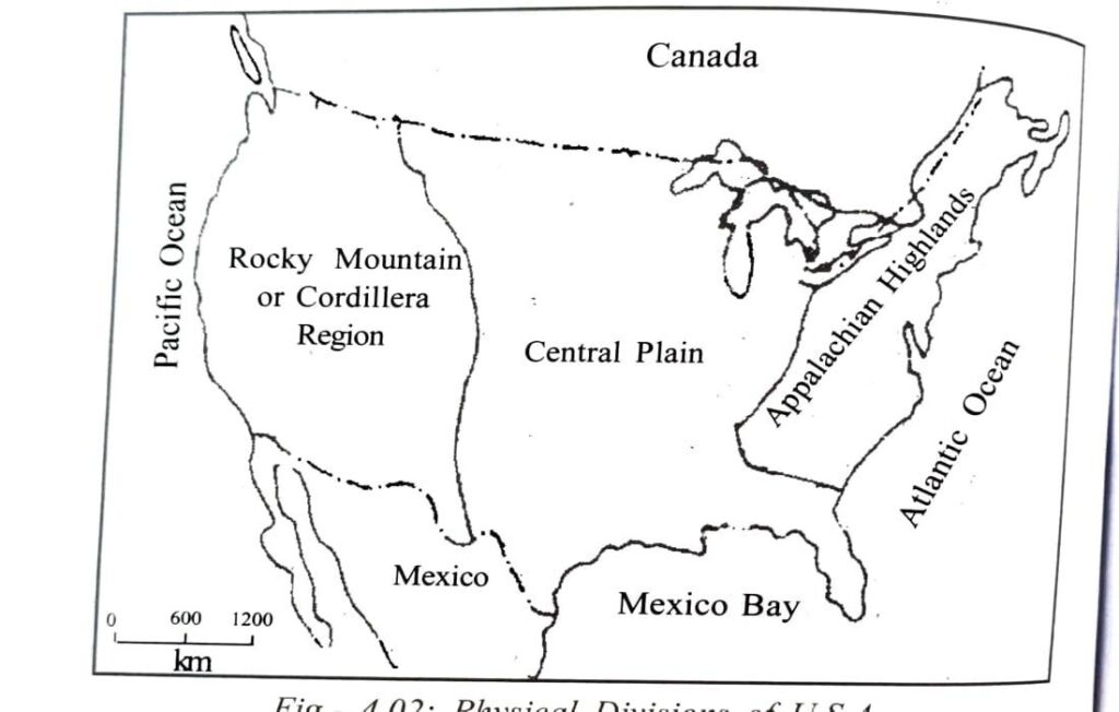
Physical Divisions: Based on the geo-physical structure, the whole of USA may be divided into three major physiographic divisions.
These divisions from east to west are:
(i) Appalachian Highlands.
(ii) Central Plains. and
(iii) Rocky Mountains or Cordillera.
(a) The Appalachian Highlands: The highlands of eastern part of USA located parallel to the Atlantic ocean is known as the Appalachian Highlands. Most of the parts of this land surface in true sense is covered by the Appalachian mountain. This region extends between the Hudson valley and the Erie-Onterio lakes in the north to the Alabama in the south. The physiography of this region is consisted of hills, mountains, plateau, plains etc and, hence, complex in character. Among these, Allegheny mountains in the west, Cumberland plateau in the south west, Appalachian mountain system and the valley in the east, Bloris mountain in the south and the Coastal lowlands in the east are worth mentioning.
(b) The Central Plain: The vast and extensive plain that lies between the Rockies in the west and the Appalachian Highland in the east is known as the Central Plain. The region extends between the Great Lake Region in the north to the Mexico Coast in the south. The plain as a whole is basically a part of the Mississippi-Missouri basin. The master stream Mississippi Missouri and their tributaries flowing through this region has developed this region into a vast fertile plain. Therefore, this plain region of USA is very suitable for agricultural purposes.
The Central Plain region in general may be divided into four divisions. The Highlands, the Great Lake Region, the Mississippi plain and the Mexico coastal lowlands. The foot-hill lowlands east of the Rockies is known as Highland plain.
(c) The Rocky Mountain or Cordillera: The region consisting of hills, mountain plateau, valleys, lakes etc that lies between the Central Plains in the east and the Pacific coastal lowland in the west is called the Cordillera region. The region is aligned in north-south direction. The structure and the physiography of the region that has grown mainly centering the Rockies are very complex. The Highlands located towards east of the region in a north-south alignment is the Rocky mountain. The Rockies, like the Himalayas are young folded mountain. Some of the peaks of the Rockies are well above 4,200 meter above the sea-level. The important mountains located west of the Cordillera are Sierra Neveda, Cascade and Coast Range. Moreover, there are few plateaus in between the two parallel ranges of the Cordillera.
3. Show on a sketch the physical divisions of USA?
Ans:
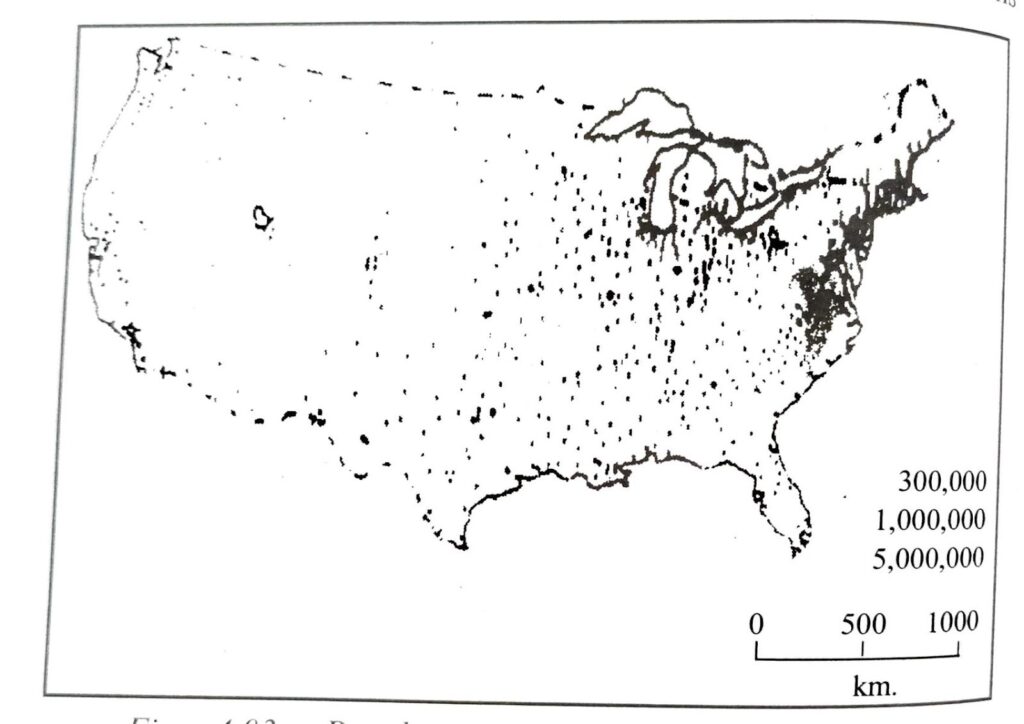
4. Discuss with the help of a sketch the growth and the distribution of population in USA?
Ans: In 1776, when 13 states joined together to declare independence of the United States of America, it had a total population of only 3 million. But after independence, due to migration of people from the European countries and merging of another 37 states at different times (in course of time), its population began to rise at a faster rate. At present, with an estimated population of 302 million in 2007, it is the third largest populous country of the world.
Table 4.1 population growth in the USA
| Census year | Population (in million) |
| 1776 | 3 |
| 1800 | 5 |
| 1850 | 23 |
| 1900 | 76 |
| 1950 | 151 |
| 1970 | 202 |
| 2000 | 281 |
| 2007 | 302 |
Now as a result of decline in natural growth as well as migration, the growth of population i is in the country According to the information of 2007, the rate of population growth in the United States is only 0.60% as against the world fe of 1.20%. Of the total population of the country 85% are white christians, other 15% are comprised of Jews, Muslims, Hiesus and Black people.
Like other areas of the world, the distribution of population in the USA is not uniform due to variation in natural condition, transportation system and development processes. In general the density of population is high in the Appalachian Highlands and Atlantic Sea board located in the eastern part of the country. On the other hand the population is very less in the Central Plain and Cordillera region. But the coastal region of California in the west is thickly populated. The south and east part of Michigan state which accounts for only 1/4 th of the total area of the country, is inhabited by 2/3rd of the total populations of the nation. The average density of population in this region is 85 persons per square kilometer as against the average density of 32 persons the United States as a whole. The states of Massachusetts, New Jerey and Rhode Island, located in this region have population density more than 300 persons per square kilometer.
5. Discuss the role of agriculture in the economy of the U.A.S?
Ans: The United States of America occupies the first place in the world in respect of natural resources, agriculture, industrial production and standard of living. The Gross National product of the country is the highest in the world. The per capita income of the nation is 38,000 dollar at present. As a result it has emerged as the largest economic power in the world. The country where, less than 5% of the world population live, produces nearly 20% of the world production of coal, copper and petroleum. It occupies important place in the world in different agricultural productions also. It is the highest producer of corn,cotton and tobacco and second highest producer of wheat and barley. It produces 46% and 18% of world production of com and wheat respectively. As a result, it can export enough goods to different countries. The value of exported materials from the U.S.A accounts for more than 10% of the total world export in the international market. It is important to note that agriculture accounts for only 2% of the Gross National Income of the country while industry accounts for 30% and trade, transport and communication accounts for 68%. Regarding land use it is seen that 1/4th of the total land of the country is under permanent agriculture of the total population aged (in the age-group) between 15-64 years 79% are engaged in different economic activities.It is interesting to note that of the total economically active population, only 5% are dependent on agriculture. In addition to agriculture, industry, trade and services, people of this country are engaged with such economic activities like fishing animal rearing, mining and lumbering. The Prairie grassland located in the south of the country is suitable for animal rearing.
The following discussion on regional agricultural system and industrialization gives some idea on the economic development of the country.
6. What do you mean by agricultural belt? How many agricultural belts have been recognised in USA? Show them on a sketch and describe each of them briefly?
Ans: The important characteristic of the agriculture of the USA is its agricultural belts. On the basis of physiography, climate, soil etc, the country is divided into several belts from east to west. In every belt importance is paid on cultivation of a special variety of crop.
Density of population is very low and hence, agriculture is highly mechanised and extensive in type. Per capita productivity compared to other states of the world is high. The main agricultural belts of USA are extended from the Atlantic coast towards west up to 100º west longitude. The whole state may be divided into nine agricultural belts from the south to the north.
Their are nine agricultural belts have been recognised in USA.
(a) Rice and Sugarcane Belt: This agricultural belt is located on the Mexican coast and includes Florida, Georgia, Alabama, Mississippi and southern part of Louisiana state. Sub-tropical climate is experienced here. Like that of tropical climate, temperature and precipitation in this region is high. The region is composed of fertile alluvial soil. Rice and wheat is abundantly grown here and hence the region has been identified as wheat and sugarcane belt. Banana and pineapple are also grown here in large quantity.
(b) The Cotton Belt: Cotton is grown just north of the wheat and sugarcane belt covering the southern part of the Mississippi valley. 36″ north parallel has bounded and demarcated the northern limit of the cotton belt. About 50% of the cotton of USA is grown in Texas, Mississippi and Arakansas state
(c) Winter Wheat and Tobacco Belt: North of the Cotton belt, from the Atlantic coast to the Colorado in the west, the belt is known as winter wheat and tobacco belt covering North Carolina, Kentucky, Virginia, and Marryland. The eastern part of this belt produces large quantity of tobacco. The western part of this belt covering Nebraska, Kansas, East Colorado, Oklahama and Texas produce winter wheat. USA exports maximum of its wheat to the world market from this region.
(d) Maize Belt: In the north of the winter wheat belt from mid Ohio to mid Nebraska maize is produced abundantly. Most of the maize of USA is obtained from lowa, Illinois, Indiana, Minnesota, Pennsylvania and Nebraska.
(e) Spring Wheat Belt: This belt is located north of the Prairies. Due to severe cold during winter, wheat is practised during spring season. Wheat is obtained mainly from Montaza, North Dakota, South Dakota, and western part of Minnesota. Superior quality of wheat is obtained from here and the excess is exported to other deficit nations of the world.
(f) Mixed Agriculture of North East: The Mixed agricultural belt of USA includes the south and the eastern states of the Great Lake Region and covers Minnesota, Wisconsin, Michigan, Pennsylvania and New England State. Basides rye and barley production animals are also reared inlarge scale based on the availability of the new grasslands. The belt is also known as the dairy farming belt.
(g) Dry Farming and Dairy Belt: The belt is consisted of the western part of the Central Plain and the eastern part of the Cordillera region. Rainfall here is low but well distributed throughout the year and hence grasses grow. The condition is congenial for rearing animal like sheep and cattle. Western part of Texas, New Mexico, Utah, Colorado, Nevada, Wyoming, Idaho and Montano etc are included in this belt. Jowar and bajra are produced under dry farming method and barley and maize are practised often with irrigation. Milk, beef, meet, wool etc are important dairy products obtained from animal rearing.
(h) The Mediterranean Agricultural Belt: California, located on the pacific coast of USA exhibits Mediterranean type of climate. Therefore, the belt is also called the Mediterranean agricultural belt. Besides wheat and cotton, citrus fruits like orange, grapes and other fruits like apple etc are produced in large scale.
(i) The mixed Farming Belt of the North West Margin: Washington, Idaho, and Oriegon located in the North- Western margin of USA are suitable for cultivation of wheat and maize. Besides production of crops, animals are reared for milk and meat. Therefore, this region is called mixed agricultural belt.
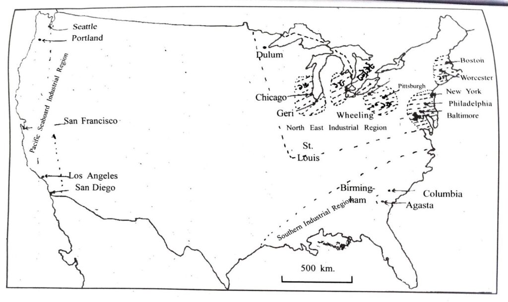
7. Name the major industries of USA and show them on a map. Describe any one of them?
Ans: Industrial Region Three major Industrial Regions of U.S.A may be identified as follows:
(i) The North East Industrial Region: Due to availability of mineral resources like coal, iron, petroleum and well developed transport and communication network, the north-eastern part of USA as an industrial region has developed. This is known as North East Industrial region. The region extends from St Luis, South of the Lake Superior and Baltimore in the east (Atlantic Coast). The region covers about 10% of the total area of USA and gives home to 50% of the total population of USA. About 75% of the total industry of USA is concentrated here. Five industrial centres are located within this industrial region.
centres are located within this industrial region.Boston Worcester York
(a) Pittsburgh, Wheeling, Cliveland Industrial Centre: This Industrial centre has grown based on the Appalachian coal centering Pennsylvania and Ohio. High quality of coal is found here, well developed transport and communication network and the better variety of iron ore available in and around the Lake Superior region, have facilitated the development of iron and steel industry in Pittsburgh, Youngstown, Wheeling, Cliveland etc. Pittusburgh has also developed in glass making and cotton textile industries. Arakon located here is the largest rubber producing Industry of the world.
(b) New York, Philadelphia-Baltimore IndustrialCentre: This vast industrial centre has grown covering the large metropolitan cities like New York, Philadelphia and Baltimore including major part of north New Jersey and parts of pennsylvania. Here, iron and steel industry, textile industry, tin, petroleum and copper refining industry in Baltimore; textile, electrical appliances, petroleum, sugar and rubber industry in Philadelphia; iron and steel industry, rail engine in east Pennsylvania; Textile, electrical goods, utensils making industry in New Jersey are world famous. On the other hand, New York is full of variety of industrial centres.
(c) Southern New England Industrial Centre: As the region is deficient in coal and other mineral resources it mainly has textile and textile machinery and leather industry based mainly on the hydroelectric power produced here. It also has paper and pulp industry depending on the softwood forest of the region. Rhode Island, Massachusetts, New Hampshire and Connecticut are the main industrial states of the region.
8. Write short notes on the following:
(a) Physiography of the Rocky mountainous region.
Ans: Region of halls, mountain plateau, valley the paste that between the Central Plains in the east and the Pacific coastal owned in the west is called the Cordillera region. The region in aligned in north-south direction. The structure and the physiography of the region that has grown mainly centering the Rockies are very complex. The Highlands located towards east of the region in a north-south alignment is the Rocky mountain The Rockies, like the Himalayas are young folded mountain. Some of the peaks of the Rockies are well above 4,200 meter above the sea level. The important mountains located west of the Cordillera are Sierra Neveda, Cascade and Coast Range.
(b) Physiography of Appalachian highland.
Ans: The region’s diverse topography with long broad ridges, steep slopes, deep gorges and wide intermountain valleys, and geologic stability over long periods of evolutionary history has resulted in a broad range of microhabitats and the presence of numerous relict species and communities.
(c) Drainages of central plain.
Ans: The Central Plain is drained by several rivers like the Rhine, Volga, Danube, Dnieper, Ural etc. These rivers form a radial pattern of drainage. They flow Into various streams in different directions from a high central area.
(d) Urbanisation of USA and the principal urban centres.
Ans: Urbanisation of the USA and the principal urban centres The USA is economically and industrially the most developed country in the world Of the total population of the country (302 million) more than 76% lives in the urban centres Thus, a major portion of the population of the USA lives in towns and cilies. New York with a population of 22 million is the largest and the most populated city in the USA The second most populated city is Los Angeles with a population of 18 million The other important urban centres of the USA are Massachusetts, New Jersey, Rhode Island, Philadelphia, Baltimore, Pittsburg Whiling, Cliveland, Detroit Michigan, San Francisco Los Angeles etc.
(e) Economic characteristics of USA.
Ans: The American economy is fueled by high productivity, well developed transportation infrastructure, and extensive natural resources. Americans have the highest average household and employee income among OECD member states. In 2021, they had the highest median household income.
(f) Agricultural belts of USA.
Ans: Agricultural activity occurs in every U.S. state, it is particularly concentrated in the Central Valley of California and in the Great Plains, a vast expanse of flat arable land in the center of the nation, in the region west of the Great Lakes and east of the Rocky Mountains.
(g) North-Eastern Industrial region of USA.
Ans: North-Eastern Region: It consists of places like Pittsburgh, Cleveland, Detroit, Chicago, Ohio, Michigan, and Wisconsin.
The Southern Industrial Region: We are talking about places like Mississippi, Tennessee, Georgia, Florida, Alabama, Oklahoma and texas.
(h) Pacific coastal Industries of USA.
Ans: This is one of the great industrial agglomerations of the Pacific coast. Its industrial centres are San Francisco and Los Angeles. fabrication, petrochemical and heavy chemical industries. The other industrial centers of this region are Portland, Seattle, Engine, Sacramento, San Diego, etc.
(i) Dry agriculture and Dairy farming belt of USA.
Ans: Dry agriculture and Dairy farming belt of USA.Crops are cultivated during the subsequent dry season, using practices that make use of the stored moisture in the soil. California, Colorado, Kansas, South Dakota, North Dakota, Montana, Nebraska. Oklahoma, Oregon, Washington, and Wyoming, in the United States, are a few states where dry farming is practiced for variety of crops.
(j) Mineral resources of USA.
Ans: Mineral resources of USA.North America is a leading producer of coal, used in energy production; bauxite, used to create aluminum, iron and copper, bath used in construction, and nickel, used to create steel, which North American companies export around the world. Gold and silver mines operate in the western part of the continent.

Hi, I’m Dev Kirtonia, Founder & CEO of Dev Library. A website that provides all SCERT, NCERT 3 to 12, and BA, B.com, B.Sc, and Computer Science with Post Graduate Notes & Suggestions, Novel, eBooks, Biography, Quotes, Study Materials, and more.


 Buy Now
1. Discuss with the help of a sketch the growth and the distribution of population in the USA
Hello sir
Class 10 chapter 5 extra questions answer elective geography
Please let me download this answers