NIOS Class 10 Social Science Chapter 10 Climate Solutions to each chapter is provided in the list so that you can easily browse through different chapters NIOS Class 10 Social Science Chapter 10 Climate and select need one. NIOS Class 10 Social Science Chapter 10 Climate Question Answers Download PDF. NIOS Study Material of Class 10 Social Science Notes Paper 213.
NIOS Class 10 Social Science Chapter 10 Climate


Also, you can read the NIOS book online in these sections Solutions by Expert Teachers as per National Institute of Open Schooling (NIOS) Book guidelines. These solutions are part of NIOS All Subject Solutions. Here we have given NIOS Class 10 Social Science Chapter 10 Climate, NIOS Secondary Course Social Science Solutions for All Chapters, You can practice these here.
Climate
Chapter: 10
SOCIAL SCIENCE
TEXT BOOK QUESTIONS WITH THEIR ANSWERS
INTEXT QUESTIONS 10.1
Q. 1. Look at the map 10.1 and answer the following questions:
(i) Name the important latitude drawn on the map which has divided India in two heat zones. Also tell the degree of that latitudes.
Ans: Tropic of Cancer ― 23°30’N.
(ii) Name the cities located on map which are influenced by the sea and cities which are not influenced by the sea.
Ans: (a) Cities influenced by the sea are:
(i) Mumbai. and
(ii) Chennai
(b) Not influenced by these are:
(i) Lucknow. and
(ii) Delhi.
(iii) Which mountain range protects our country from cold breeze of Central Asia?
Ans: Himalayan mountain range.
(iv) Observe the wind direction given on the map and tell why do we have dry winter season.
Ans: These winds are coming from north east. Since they are coming from land they are dry and unable to give rain to the country.
INTEXT QUESTIONS 10.2
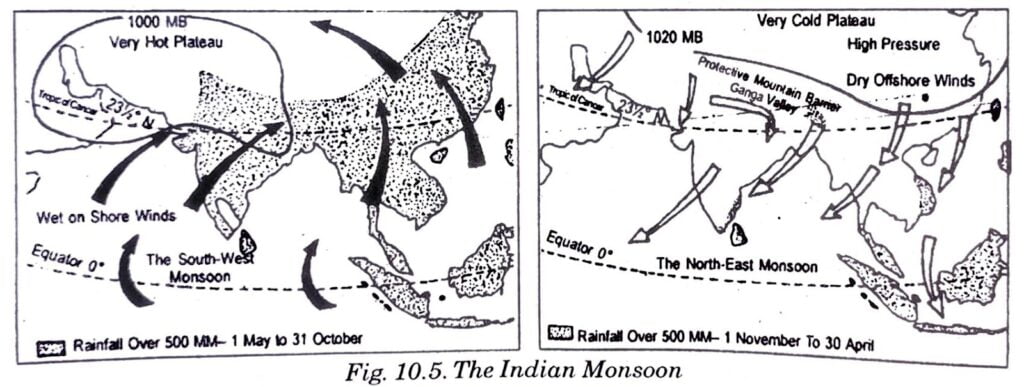
Look at the map (10.2 fig.) of advancing monsoon and answer the following questions:
Q. 1. Name the states which lie with in the low pressure regions:
Ans: Rajasthan, Punjab, Haryana, Uttar Pradesh, Bihar, Jharkhand, West Bengal, M.P. and Chhattisgarh and parts of Odisha.
Q. 2. As the monsoon winds are coming from south west which state they will strike first?
Ans: Kerala.
Q. 3. When the monsoon winds reach the Bay of Bengal what is their direction?
Ans: West.
Q. 4. Observe the rainfall data of the following cities and find out the average duration of monsoon in four cities. Name of the cities are: Mumbai, Jaisalmer, Delhi and Shillong.
Ans: Mumbai 4 months, Jaisalmer – 2 months, Delhi 4 months, Shillong 6 months.
INTEXT QUESTIONS 10.3
Choose the correct answers:
(i) The hot and dry winds blowing in the northern plain in the summer are called:
(a) Kal Baisakhi
(b) Loo
(c) Trade winds
(d) All of the above
Ans: (b) Loo.
(ii) Which mountain range acts as a barrier in the path of the Arabian sea branch?
(a) Aravallis
(b) Eastern Ghats
(c) Western Ghats
(d) Raj Mahal Hills.
Ans: (b) Western Ghats
(iii) The tropical cyclones of the Bay of Bengal usually occur during
(a) South west monsoon
(b) Hot weather season
(c) Retreating monsoon season
(d) Cold weather season
Ans: (c) Retreating monsoon season.
(iv) Which place would be the hottest one in March?
(a) Delhi
(b) Shillong
(c) Deccan Plateau
(d) Punjab.
Ans: (c) Deccan Plateau
(v) Monsoons are called:
(a) Seasonal winds
(b) Temporary winds
(c) Permanent winds
(d) Local winds
Ans: (a) Seasonal winds.
INTEXT QUESTIONS 10.4
Q. 1. Why do we find the rainfall distribution in India highly uneven?
Ans: When monsoon winds enter from the western coast they give the maximum rainfall on this coast. When they reach central or northern region they became dry resulting less rainfall.
Q. 2. Name the three regions of India receiving lowest rainfall.
Ans: Regions of low rainfall:
(a) Northern Leh-Ladakh Region.
(b) Western Rajasthan. and
(c) South-Central part.
Q. 3. Name the month of Kharif and Rabi seasons.
Ans: Kharif season – June and July. Rabi season – October and November.
Q.4. When do we have the Zaid season?
Ans: From the end of the winter season March-May,
Q. 5. Which human activities are responsible for global warming?
Ans: Urbanization, industrialisation, deforestation, burning of fossil fuels etc.
TERMINAL EXERCISES
Q. 1. Describe any five factors which are responsible for affecting the climate. Explain with the help of examples for each factor.
Ans: The factors which are responsible for affecting the climate are as under:
1. Location: The places which are closer to equator have high temperature. As one moves towards the poles temperature decreases. India is located in northern hemisphere closer to equator at 8°.4′ N and 23°30′ N. Tropic of Cancer passes through the central parts of India. So in south we find tropical climate. For example Andhra Pradesh would be hotter than Haryana.
2. Distance from the sea: India is surrounded by sea on three sides. Hence, the southern half of the country is neither very hot in summer not very cold in winter.
3. Altitude: Attitude also affects the climate of a country. With rise in altitude temperature decreases. For example Shimla and Ludhiana both lie on same latitude but Shimla is much cooler than Ludhiana because the higher attitude.
4. Mountain ranges: Mountain ranges affect the climate to a great extent. Himalayas prevent very cold winds from entering India and they check rain bearing winds of South West monsoon and compell them to shed the moisture in India. Due to this factor northern India receives rain during the rainy season.
5. Direction of surface winds: These winds also affect the climate of India. The winds blow from land to sea are cold and dry and do not cause rainfall while the winds blow from sea to land are moisture- laden winds cause rain in most parts of the country.
6. Upper air currents or Jet Stream: Besides the surface winds jet streams are responsible for sudden outbreak of the monsoon in North India.
Q. 2. Distinguish between climate and weather.
Ans: Climate: Climate refers to the sum total of weather conditions and variation over large area for a long period of time (more than 30 years).
Weather: It is the state of atmosphere over an area at any point of time. Similarly weather conditions which last for longer duration are responsible for making a season.
Q. 3. How are winds and their direction responsible for affecting the climate? Explain by giving examples.
Ans: The winds and their direction affects the climate of India to a great extent. The system of winds consists of monsoon, land and sea breezes and local winds. In winter the winds blow from land to sea so they are cold and dry. That is why the northern Indian plains are colder than the other parts. On the other hand, in summer winds blow from sea to land bringing the moisture along with them from sea and they cause wide spread rain in most part of the country. It is therefore our country gets rain from these winds in summer.
Q. 4. Define monsoon. Identify the main reason which is responsible for moving trade winds in opposite direction.
Ans: Monsoon: Seasonal reversal in the direction of wind during a year is called monsoon. The difference of temperature and resultant pressure over north central Indian Plains and Indian Ocean. Due to this difference air from high pressure region of sea starts moving towards the low pressure region of north India. Thus by mid-June the general movement of air is from equatorial region of Indian Ocean to the Indian subcontinent and the direction of these winds in general is from south west to north east. This direction is exactly opposite to that of the trade winds. This is the only reason for moving trade winds in opposite direction.
Q. 5. Mention any four character- istics of cold weather season.
Ans: 1. Cold weather season occurs in from December to February.
2. The temperature decreases during this season.
3. December and January are the coldest months.
4. Frost is common in north and north west India.
5. Some rainfall pours in this region due to the western disturbances.
6. Tamil Nadu coast receives heavy rainfall due to north east trade winds.
Q. 6. List any four main features of hot weather season.
Ans: 1. The period of hot weather season is March to May.
2. Rise in temperature but fall in air pressure is observed in northern part of the country.
3. Hot wind Loo starts blowing.
4. Dust storms bring down the temperature temporary.
5. Pre-monsoon showers including Mango showers are received in the South India.
Q. 7. By giving examples explain the effects of the global warming in India. What are causes behind it?
Ans: Now a days global warming is a burning topic. It has political, social and economic impacts on our lives and life style.
The causes of behind global warming are urbanization, industrialisation and population growth. The atmosphere has been polluted. Human activities increase the amount of carbon dioxide, chlorofloro carbans and other dangerous gasses.
SOME OTHER IMPORTANT QUESTIONS FOR EXAMINATION
VERY SHORT ANSWER TYPE QUESTIONS
Q. 1. What are the Jet streams?
Ans: A Jet stream is a fast blowing wind in a narrow zone in the upper atmosphere at the height of about 3 km. It influence the climate of South East Asia.
Q. 2. Which parts of India experience Mango Showers?
Ans: Coastal areas of Kerala and Karnataka.
Q. 3. What is Kalbaisakhi?
Ans: Thunderstorms which cause heavy rainfall in West Bengal and Assam in the month of April have the local nomenclature Kalbaisakhi (Calamity of the month of Baisakh).
Q. 4. When does the retreat of South West Monsoon begin in India?
Ans: Beginning of October.
Q. 5. Name the place that gets the maximum rainfall in India.
Ans: Mawsynram (1108 cm.).
Q. 6. Give two characteristics of tropical climate.
Ans: Uniformly high temperature almost throughout the year and high rainfall with a distinct dry period.
Q. 7. What is Loo?
Ans: Hot and dry winds that blow in summers in the northern and north western plain of India.
Q. 8. In which direction does the rainfall decreases in the rainy season in India?
Ans: It decreases from east to west and from south to north.
Q. 9. What governs the distribution of rainfall given by the south west monsoon?
Ans: Topographic relief.
Q. 10. Why is the cold season dry over most parts of the country?
Ans: It is dry because off shore cold and dry winds from the north east effect the region.
Q. 11. Which part of the country experience highest day temperature in the month of March?
Ans: Deccan Trap.
Q. 12. Where does the heart of low pressure trough lies in the summer season?
Ans: In the northwestern region of India.
Q. 13. What causes deflection of South West monsoon in the Bay of Bengal?
Ans: The Arakan mountains.
Q. 14. What is break or burst of monsoon?
Ans: The sudden approach of moisture laden strong violent winds associated with thunder and lightning is called burst of monsoon.
Q. 15. What is October Heat?
Ans: In northern India, due to high temperature and humidity the weather becomes oppressive in the month of October. This is called October Heat.
Q. 16. What is the reason of bulk of rainfall on the coromandel coast in the season of retreating monsoon?
Ans: Tropical depression originating over the Andaman Sea.
Q. 17. Why Punjab get rains in winter?
Ans: Due to western disturbances originating in the east Mediterranean sea.
Q. 18. What is a cold wave?
Ans: Sudden fall in temperature by five or more degrees from the normal generally after the rains in winter.
Q. 19. What is the location of Jet Stream in the month of January?
Ans: A westerly Jet Stream in lower stratosphere is placed south of the Himalayas in January.
Q. 20. Where do ‘Norwesters’ blow in our country.
Ans: ‘Norwesters’ blow in north eastern parts of our country.
Q. 21. Why do rains in Delhi begin much later than they do in Trivandrum?
Ans: Moisture bearing winds take at least four weeks to reach the northern plains. So Delhi starts its rainy season in July while Trivandrum starts it in the month of June.
Q. 22. Why do the north east trade winds change their direction while blowing through the Ganga Valley?
Ans: Topography of the region influence the wind direction.
Q. 23. Name two places in India which have an extreme climate.
Ans: Jodhpur and Delhi.
Q. 24. Which phenomenon is responsible for the rise of South West monsoons?
Ans: Southern Oscillation.
Q. 25. What is monsoonal trough ? How is it created?
Ans: During the summer the interior parts of North Indian plains are intensely heated. In some parts of the region the temperature touches 50°C. The high temperature heats up the air lying on the above region and the low pressure is established. This low pressure is known as monsoonal trough.
Q. 36. What is ENSO?
Ans: The phenomenon that occurs due to periodic change in pressure condition and flow of a warm ocean current (El Nino) is called ENSO (i.e., El Nino South Oscillations).
SHORT ANSWER TYPE QUESTIONS
Q. 1. Why does Mahabaleshwar receive more rainfall than Pune?
Ans: Mahabaleshwar receives more rainfall than Pune. It is because when the south west monsoon winds coming from Arabian Sea to Western Ghats they are causing very heavy rainfall on the western slope that is windward side of the Ghats. Very little rainfall is received from these winds on the eastern slope which is the leeward side of Ghats. Mahabaleshwar is situated on the wind-ward side of the Ghats hence receives heavy rainfall and Pune is located leeward hence it receives less rainfall.
Q. 2. Why does monsoons start retreating in north India?
Ans: The monsoon start retreating from north India from September onward. The temperature during September-October starts decreasing in north India. With these decrease in temperature monsoonal trough also becomes weak over northwest India. That is why monsoons start retreating from September onward.
Q. 3. Describe the characteristics of Indian Monsoon in short.
Ans: Characteristics of Monsoon:
1. Sometimes the monsoon come early, normal or late.
2. The monsoon may retreat early, normal
3. The amount of rainfall each year may vary.
4. Uncertain and variable rainfall.
5. Monsoons provide climatic unity of sub-continent.
6. When the monsoons come in full swing or it may fall together. Thus causing the problems of flood and famines.
Q. 4. Why do western coastal lands and north eastern part of India receive very heavy rain?
Ans: South west monsoon coming from the Arabian Sea strike Western Ghats and causes very heavy rainfall. Therefore coastal lands receive the heavy rain as these are in windward side.
The monsoon that move from Bay of Bengal strike north eastern parts of India. They cause heavy rainfall in the region.
Q. 5. The Deltas of the Godavari, Krishna and Kaveri are frequently struck dry cyclones. Give reasons.
Ans: The low pressure conditions are: formed during October and November every year on the Bay of Bengal. Owing to this shift of transfer of pressure cyclonic depression is formed in the Andaman Sea. These are called tropical cyclones and spread devastation in eastern coast deltas.
Q. 6. Distinguish between Northeast Monsoon and Retreating Monsoon.
Ans:
| Northeast Monsoon | Retreating Monsoon |
| 1. These winds blow from December to February. | 1. These winds blow during October and November. |
| 2. The direction of winds is from north east to south west. | 2. The winds are calm. |
| 3. The pressure on land area is high. The sky is clear. The temperature comes down. Only Tamil Nadu coast receives rainfall from these monsoons. | 3. The temperature increases again. The land being covered with rainy water. The humidity becomes high. The temperature goes up. The coastal area of Tamil Nadu receives maximum rainfall from these monsoons winds. |
Q. 7. Give the characteristics of the monsoon rainfall in India.
Ans: Characteristics of Monsoon rainfall:
1. It gives water to the entire territories of India except some leeward side rain shadow regions and Thar desert.
2. Early in the season the windward side of the Western Ghats receives heavy rainfall.
3. The rain shadow area of Deccan plateau and parts of Madhya Pradesh also receive scanty rains.
4. The maximum rainfall is recorded in the part of the country e.g., the heaviest rainfall in Mawsynram.
5. Indian monsoon takes breaks viz interspersed with rainless intervals. This happens because of monsoon trough is determiner of the spatial distribution of rainfall.
6. The frequency and intensity of tropical depression also determine the amount and duration of monsoon rains.
7. The monsoon trough over the northern plains becomes weaker causing the months of October and November a period of transition from hot rainy season to dry winter condition.
Q. 8. Why is Shillong rainier than Kolkata ? Give two reasons.
Ans: Shillong is rainier than Kolkata because:
1. Relief plays an important role in distribution of rainfall received from south west monsoon.
2. Shillong lies in Garo and Khasi Hills and monsoon after striking the hills cause heavy rainfall there. Kolkata on the other hand, is situated away from the influence of relief though near sea receives less rainfall.
Q. 9. Chennai gets rainfall in winter than summer. Give two reasons. (Imp.)
Ans: Tamil Nadu lies on the Coromandel coast on the eastern coastal plain. This region receives rainfall in winter as well as summer. It receives most of the rainfall in winter.
(i) In summer, Tamil Nadu remains dry as this plain lies in the rain shadow area of Western Ghats.
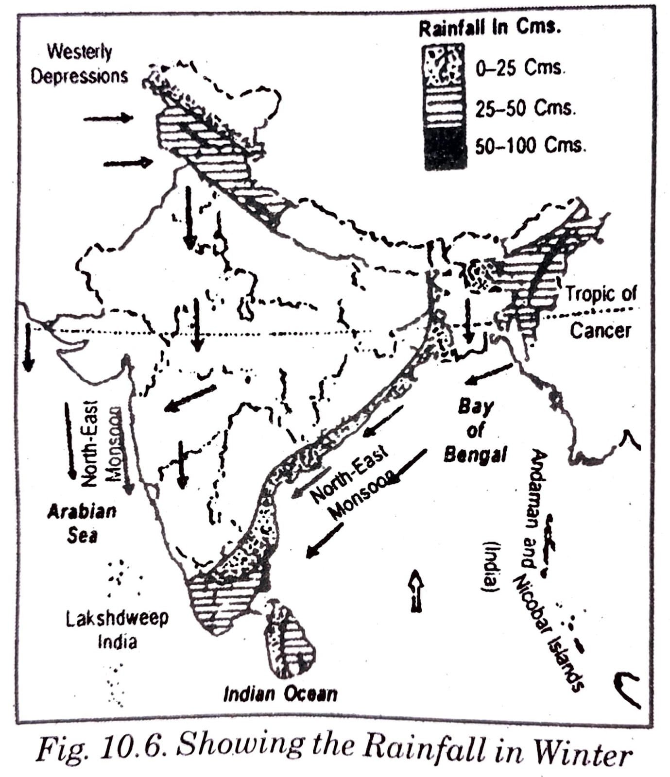
(ii) In winter north-east monsoon pick up moisture as this cross Bay of Bengal. These retreating monsoons are no shore winds in Tamil Nadu coastal plain. The Eastern Ghats for eastern winds to give moderate rainfall in this area.
Q. 10. Why are south west monsoon less rainier in Chennai?
Ans: Chennai falls in the rain shadow area of Eastern Ghats (at Coromandel coast). Owing to this Chennai receives less rains from the south west monsoon winds.
Q. 11. Parts of Rajasthan, Gujarat and leeward side of Western Ghats are drought prone areas. Why?
Ans: Owing to vagaries of the monsoon the annual rainfall is highly variable from year to year. Variability is high in the regions of low rainfall such as parts of Rajasthan, Gujarat and leeward side of Western Ghats. Areas of low rainfall are drought prone. While areas of high rainfall are liable to be affected by floods.
Q. 12. What is I.T.C.Z.?
Ans: It is Inter Tropical Convergence Zone where the North East and South East trade winds collide. It is also called a trough of low pressure in equatorial latitudes. This zone is parallel to the equator but moves north or south with movement of the sun.
Q. 13. What is El Nino?
Ans: It is a warm ocean current flown over Peru in an interval of two to five years. It is the term derived from Spanish which means the child i.e., baby Christ. It flows in December month.
Q. 14. Why do Trivendrum receive equable climate?
Ans: 1. Trivandrum is free from the hot climate of the Temperate zone because of its location on hill side. We know that the temperature recedes with the higher altitude of the land from the sea bed.
2. This capital city (now Thiruvananthapuram) is in vicinity to the Arabian sea which maintains b here, the moderate temperature throughout the year.

Hi! my Name is Parimal Roy. I have completed my Bachelor’s degree in Philosophy (B.A.) from Silapathar General College. Currently, I am working as an HR Manager at Dev Library. It is a website that provides study materials for students from Class 3 to 12, including SCERT and NCERT notes. It also offers resources for BA, B.Com, B.Sc, and Computer Science, along with postgraduate notes. Besides study materials, the website has novels, eBooks, health and finance articles, biographies, quotes, and more.