
Class 11 Geography Chapter 10 Atmospheric Circulation and Weather Systems The answer to each chapter is provided in the list so that you can easily browse throughout different chapters SCERT Class 11 Geography Chapter 10 Atmospheric Circulation and Weather Systems and select need one.
Class 11 Geography Chapter 10 Atmospheric Circulation and Weather Systems


Also, you can read the SCERT book online in these sections Solutions by Expert Teachers as per SCERT (CBSE) Book guidelines. These solutions are part of SCERT All Subject Solutions. Here we have given Assam Board/NCERT Class 11 Geography Chapter 10 Atmospheric Circulation and Weather Systems Solutions for All Subject, You can practice these here…
Atmospheric Circulation and Weather Systems
Chapter: 10
PART-1
GEOGRAPHY
TEXTUAL QUESTION & ANSWER
Q.1. If the surface air pressure is 1,000 millibar, the air pressure at 1km above the surface will be:
(i) 700mb
(ii) 1,100,mb
(iii) 9,00mb
(iv) 1,300mb
Ans: (iii) 9,00mb
Q.2. The Inter Tropical convergence zone normally occurs:
(i) near the equator
(ii) near the tropic of cancer
(iii) near the tropic of Capricorn
(iv) near the Arctic Ocean
Ans: (i) near the equator
Q.3. The direction of wind around a low pressure in northern hemisphere is-
(i) Clockwise
(ii) Perpendicular to isobars
(iii) Anti-clock wise
(iv) Parallel to isobars
Ans:(iii) Anti-clock wise
Q.4. Which one of the following is the source region for the formation of air masses?
(i) The Equatorial forest
(ii) The Himalayas
(iii) The Siberian plain
(iv) The Deccan plateau
Ans: (iii) The Siberian plain
(b) Answer the following questions in about 30 words.
Q.1. What is the unit used in measuring pressure? Why is the pressure measured at station level reduced to the sea level in preparation of weather maps?
Ans: The unit used in measuring pressure is the mb and Pascals.The sea level is the permanent level and the gravity of all places are equal.That is why the pressure measured at station level is reduced to the sea level in preparation of weather maps.
Q.2. While the pressure gradient force is from north to south, ie, from the subtropical high pressure to the northern hemisphere, why are the winds north easterlies in the tropics?
Ans: The winds blow from high pressure to low pressure areas. In the northern hemisphere, when winds move from subtropical high pressure to the equator, the winds slightly deviate towards the east, due to the rotation of the earth i.e., coriolis force. So, it is seen as north easterlies in the tropics.
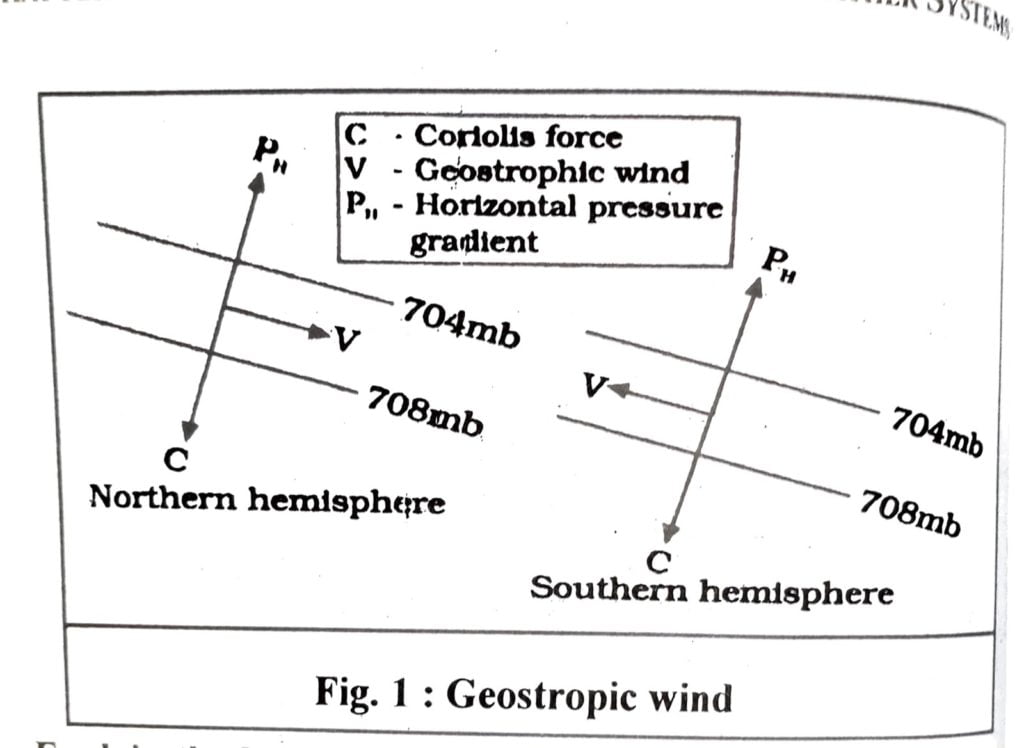
Q.3. What are the geotropic winds?
Ans The winds in the upper atmosphere (above 2-3 km. from surface) are free from frictional effect of the surface are controlled mainly by the pressure gradient and the coriolis force and the resultant wind blows parallel to the isobar. The wind is known as the geotropic winds (fig.1)
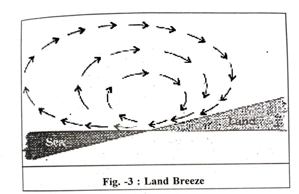
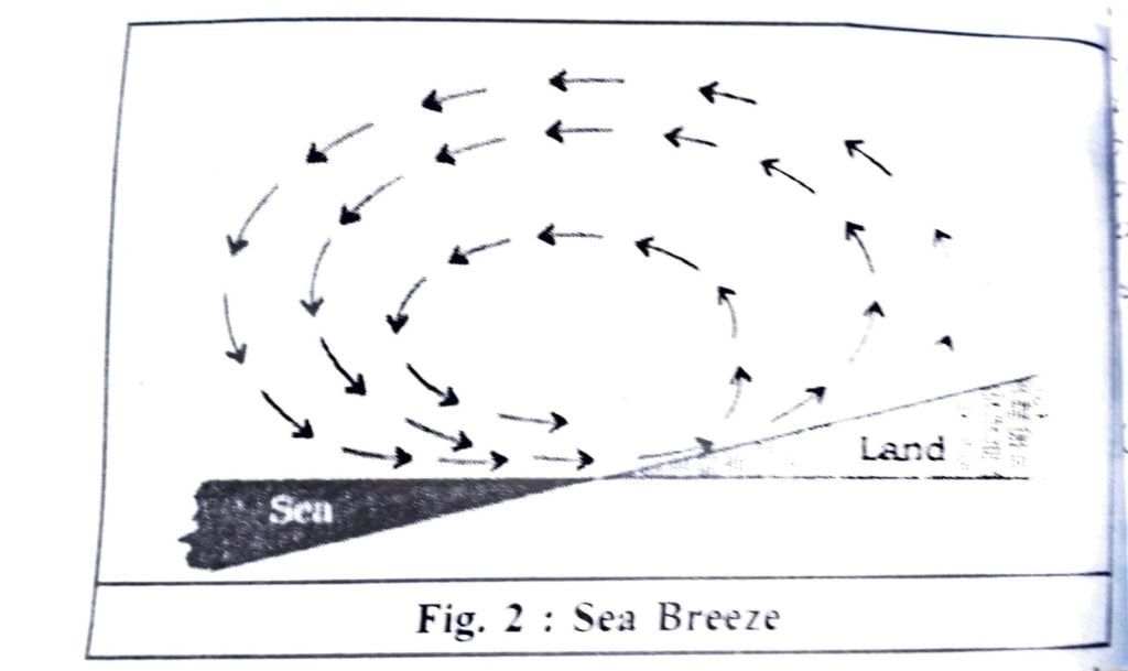
Q.4. Explain the land and sea breezes.
Ans: Sea breeze: During the day, the landmass heats up faster and becomes warmer than the sea. Therefore, over the land the air rises to a low pressure area, whereas the sea is relatively cool and the pressure over sea relatively high. In this situation the wind blows from the sea to the land and this wind is called a sea breeze.
Land Breeze: During the night time the land cools faster than the water mass. Therefore, the air is higher on the land than on the sea. As a result the winds blow from the lands towards the sea. As a result the winds blow from the lands towards the sea. And this wind is called a land breeze.
(c) Answer the following questions in about 150 words.
Q.1. Discuss the factors affecting the speed and direction of wind
Ans: The air in motion is called wind. The wind from high pressure to low pressure. The following are the major factors affecting the speed and direction of wind.
(a) Pressure gradient force
(b) Frictional force
(c) Coriolis force
(d) Centripetal acceleration
(a) Pressure gradient: The difference in atmospheric pressure produces a force. According to the location and distance of the pressure center the speed and direction of winds depends.
(b) Frictional Force: The surface of the earth’s is not even. Due to unevenness the wind at the surface experiences friction. The effects of friction are more at the surface and its influence generally extends upto an elevation of 1-3 km. Over the sea surface the friction is minimal.
(c) Coriolis Force: Due to the coriolis force, the winds deflect to the right direction in the northern hemisphere and to the left in the southern hemisphere. The coriolis force is directly proportional to the angle of latitude. It is maximum at the equator.
(d) Centripetal acceleration: Centripetal acceleration of air of the rotating earth responsible for the speed and direction of wind.
| Sl. No. | CONTENTS |
| Chapter 1 | Geography As A Discipline |
| Chapter 2 | The Origin and Evolution of the Earth |
| Chapter 3 | Interior of the Earth |
| Chapter 4 | Distribution of Oceans And Continents |
| Chapter 5 | Minerals and Rocks |
| Chapter 6 | Geomorphic Processes |
| Chapter 7 | Landforms and Their Evolution |
| Chapter 8 | Composition and Structure of Atmosphere |
| Chapter 9 | Solar Radiation, Heat balance, and Temperature |
| Chapter 10 | Atmospheric Circulation and Weather Systems |
| Chapter 11 | Water in the Atmosphere |
| Chapter 12 | World Climate and Climate Change |
| Chapter 13 | Water (Oceans) |
| Chapter 14 | Movements of Ocean Water |
| Chapter 15 | Life on the Earth |
| Chapter 16 | Biodiversity And Conservation |
| Chapter 17 | Indian Location |
| Chapter 18 | Structure and Physiography |
| Chapter 19 | Drainage System |
| Chapter 20 | Climate |
| Chapter 21 | Natural Vegetation |
| Chapter 22 | Soils |
| Chapter 23 | Natural Hazards and Disasters |
Q.2. Draw a simplified diagram to show the general circulation of the atmosphere over the globe. What are the possible reasons for the formation of subtropical high pressure over 30°N and S. latitude?
Ans: The following diagram shows the general circulation of the atmosphere over the globe.
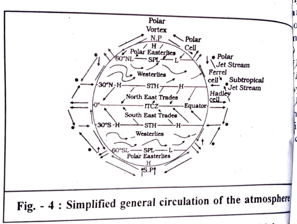
The possible reason for the formation of subtropical high pressure over 30°N and S latitude are:
1. The air at the ITCZ rises because of convection caused by high insulation and a low pressure is created. The winds from the tropics converge at this low pressure zone. The converged air rises along with the convective cell. It reaches the top of the troposphere up to an altitude of 14km. and moves towards the poles. This causes accumulation of air at about 30°N and S. latitudes. Part of the accumulated air sinks to the ground and forms a subtropical high.
2. Another cause for subtropical high pressure is that the cooling of air, when it reaches 30°N and S latitudes, the air flows towards the equator as the easterlies from either side of the equator converge in this ITCZ. In the middle latitudes the circulation is that of sinking cold air that comes from the poles and the rising warm air that blows from the subtropical high. That is why we have seen the high pressure over the subtropical zones.
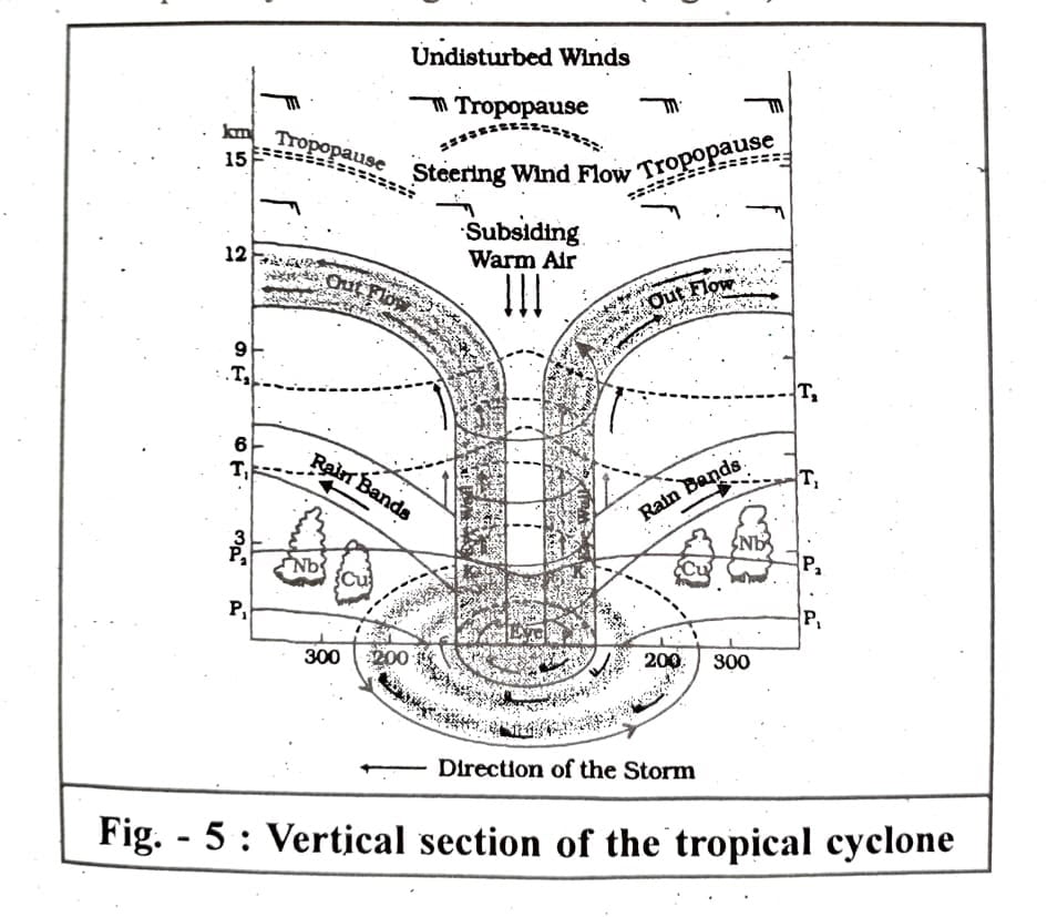
Q.3. Why does tropical cyclones originate over the seas? In which part of the tropical cyclone do torrential rains and high-velocity winds blow and why?
Ans: For the following reasons, tropical cyclones originate over the seas.
1. Large sea surface with temperature higher 27°C.
2. Presence of the Coriolis force.
3. Small variations in the vertical wind speed.
4. A pre-existing weak low pressure area.
5. Upper divergence above the level system.
The eye of a cyclone is a region of a tropical cyclone, where torrential rain occurs and the high-velocity winds blow(Over 250km/hour). A vertical section of a tropical cyclone is given below.

Hi, I’m Dev Kirtonia, Founder & CEO of Dev Library. A website that provides all SCERT, NCERT 3 to 12, and BA, B.com, B.Sc, and Computer Science with Post Graduate Notes & Suggestions, Novel, eBooks, Biography, Quotes, Study Materials, and more.
