
Class 11 Geography Chapter 13 Water (Oceans) The answer to each chapter is provided in the list so that you can easily browse throughout different chapters SCERT Class 11 Geography Chapter 13 Water (Oceans) and select need one.
Class 11 Geography Chapter 13 Water (Oceans)


Also, you can read the SCERT book online in these sections Solutions by Expert Teachers as per SCERT (CBSE) Book guidelines. These solutions are part of SCERT All Subject Solutions. Here we have given Assam Board/NCERT Class 11 Geography Chapter 13 Water (Oceans) Solutions for All Subject, You can practice these here…
Water (Oceans)
Chapter: 13
PART-1
GEOGRAPHY
TEXTUAL QUESTION & ANSWER
Q.1. Identify the element which is not a part of the hydrological cycle-
(i) Evaporation
(ii) Hydration
(iii) Precipitation
(iv) Condensation
Ans: (ii) Hydration
Q.2. The average depth of continental slope varies between-
(i) 2-20m
(ii) 200-2000m
(iii) 20-200m
(iv) 2000-20,000m
Ans:(iv) 2000-20,000m
Q.3. Which one of the following is not a minor relief feature in the oceans-
(i) Seamount
(ii) Atoll
(iii) Oceanic Deep
(iv) Guyton
Ans:(ii) Atoll
Q.4. Salinity is expressed as the amount of salt in grams dissolved seawater per per-
(i) 10gm.
(ii) 1000gm.
(iii) 100gm.
(iv) 10000gm.
Ans: (iv) 10000gm.
Q.5. Which one of the following is the smallest oceans-
(i) Indian Ocean
(ii) Arctic Ocean
(iii) Atlantic Ocean
(iv) Pacific Ocean
Ans: Arctic Ocean
(b) Answer the following questions in about 30 words.
Q.1. Why do we call the earth a Blue planet?
Ans: Among the eight planets of the solar system including the sun, there is no water. But water is found only in earth, which covers about 71 p.c. of its surface area. Moreover, if we observe the earth from the satellite it looks like a blue carpet due to its more water bodies. That is why the earth is also called a “Blue planet”.
Q.2. What is continental margin?
Ans: The continental shelf together with the continental slope is called the continental margin.
Q.3. List out the deepest trenches of various oceans.
Ans: Pacific Ocean:
(a) Mariana trench (11022m)
(b) Philippines trench (10475m)
(c) Japan trench (10554m)
(d) Curlie trench (10498m)
(e) Alucian trench (7682m)
(f) Atacama trench (7635m)
(g) Tanga trench (10882m)
Atlantic Ocean:
(a) Romanche trench (7631m)
(b) Puerto Rico trench (8385m)
Indian Ocean:(a) Java or Sunda trench (7454m)
Q.4. What is a thermocline?
Ans: The boundary region from where there is a rapid decrease of temperature of ocean water, is called the thermocline.
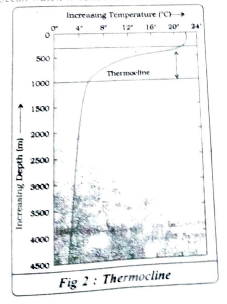
Q.5. When you move into the ocean what thermal layers would you encounter? Why does the temperature vary with depth?
Ans: When we move into the ocean water we will encounter the following three thermal layers:
The first layer represents the top layer of warm oceanic and it is about 500m thick with temperatures ranging between 20°-25°c.
The second layer is called the thermocline layer characterised by rapid decrease in temperature with increasing depth. It is 500-1000m. thick. The third layer is very cold and extends upto the deep ocean floor.
The temperature of ocean water varies with the depth because of the structure of ocean water.
| Sl. No. | CONTENTS |
| Chapter 1 | Geography As A Discipline |
| Chapter 2 | The Origin and Evolution of the Earth |
| Chapter 3 | Interior of the Earth |
| Chapter 4 | Distribution of Oceans And Continents |
| Chapter 5 | Minerals and Rocks |
| Chapter 6 | Geomorphic Processes |
| Chapter 7 | Landforms and Their Evolution |
| Chapter 8 | Composition and Structure of Atmosphere |
| Chapter 9 | Solar Radiation, Heat balance, and Temperature |
| Chapter 10 | Atmospheric Circulation and Weather Systems |
| Chapter 11 | Water in the Atmosphere |
| Chapter 12 | World Climate and Climate Change |
| Chapter 13 | Water (Oceans) |
| Chapter 14 | Movements of Ocean Water |
| Chapter 15 | Life on the Earth |
| Chapter 16 | Biodiversity And Conservation |
| Chapter 17 | Indian Location |
| Chapter 18 | Structure and Physiography |
| Chapter 19 | Drainage System |
| Chapter 20 | Climate |
| Chapter 21 | Natural Vegetation |
| Chapter 22 | Soils |
| Chapter 23 | Natural Hazards and Disasters |
Q.6. What is salinity of seawater?
Ans: Salinity is the term used to define the total content of dissolved salts in seawater. It is calculated as the amount of salt (in gm) dissolved in 1000 gm of sea water.
(c) Answer the following questions in about 150 words.
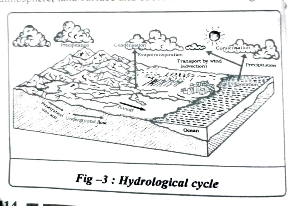
Q.1. How are various elements of the hydrological cycle interrelated?
Ans: The hydrological cycle refers to the circulation of water within the earth’s hydrosphere in different forms, i.e. the liquid, solid, and the gaseous phases. It also refers to the continuous exchange of water between the oceans atmosphere, land surface and subsurface and the organisms. From the above definition of the hydrological cycle it is clear that the various elements of the hydrological cycle are air (atmosphere) and water. Water on the earth exists in three forms liquid, gaseous and solid.
All the forms are found in different locations. The gaseous state is present in earth’s atmosphere water vapour, the solid state is found in forms of ice and snow while the liquid state is found in the forms of water. It is always in movement and its changing starts from liquid to vapour to vapour to ice and vice versa.
Q.3. Examine the factors that influence the temperature distribution of the oceans.
Ans: The factors which influence the temperature distribution of the oceans water are as follows:
(a) Latitude: The temperature of surface water decreases from the equator towards the poles because the amount of insolation decreases pole ward.
(b) Unequal distribution of land and water: The oceans in the northern hemisphere receive more heat due to their contact with larger extent of land than the oceans in the southern hemisphere.
(c) Prevailing wind: Prevailing wind is another noted factor that affects the temperature distribution of oceans. The winds blowing from the land towards the oceans drive warm surface water away from the coast resulting in the upwelling of cold water from below. It results in longitudinal variation in the temperature.
(d) Ocean currents: Warm ocean currents raise the temperature in cold areas, while the cold currents decrease the temperature in warm ocean areas. Example, the Gulf stream(warm current) raises the temperature near the eastern coast of North America and the West of Europe while the Labrador current (cold current) lowers the temperature near the north east coast of North America.

Hi, I’m Dev Kirtonia, Founder & CEO of Dev Library. A website that provides all SCERT, NCERT 3 to 12, and BA, B.com, B.Sc, and Computer Science with Post Graduate Notes & Suggestions, Novel, eBooks, Biography, Quotes, Study Materials, and more.
