
Class 10 Elective Geography Chapter 6 Regional Geography of India Question answer to each chapter is provided in the list so that you can easily browse throughout different chapters Assam Board Class 10 Elective Geography Chapter 6 Regional Geography of India and select needs one.
Class 10 Geography Elective Chapter 6 Regional Geography of India


Also, you can read the SCERT book online in these sections Solutions by Expert Teachers as per SCERT (CBSE) Book guidelines. These solutions are part of SCERT All Subject Solutions. Here we have given SEBA Class 10 Elective Geography Chapter 6 Question Answer Regional Geography of India, Elective Geography Class 10 SEBA Question Answer for All Subject, You can practice these here.
Regional Geography of India
Chapter: 6
Textual Questions And Answers
Q.1. Give a brief introduction to India.
Ans: Our country is the most diverse country in the world whether in terms of its culture and heritage or geographical features. Here in this article, you will get a chance to know your country India. This article will help the students of Class 6 and higher classes to get a brief understanding about our country. Read the notes and observe the maps and diagrams properly to retain the information.
India, country that occupies the greater part of South Asia. India is made up of 28 states and eight union territories, and its national capital is New Delhi, built in the 20th century just south of the historic hub of Old Delhi to serve as India’s administrative centre. Its government is a constitutional republic that represents a highly diverse population consisting of thousands of ethnic groups and hundreds of languages. India became the world’s most populous country in 2023, according to estimates by the United Nations.
It is known from archaeological evidence that a highly sophisticated urbanized culture—the Indus civilization— dominated the northwestern part of the subcontinent from about 2600 to 2000 BCE. From that period on, India functioned as a virtually self-contained political and cultural arena, which gave rise to a distinctive tradition that was associated primarily with Hinduism, the roots of which can largely be traced to the Indus civilization. Other religions, notably Buddhism and Jainism, originated in India—though their presence there is now quite small—and throughout the centuries residents of the subcontinent developed a rich intellectual life in such fields as mathematics, astronomy, architecture, literature, music, and the fine arts.
Q.2. Discuss the characteristics relating to India’s location and size.
Ans: India is situated in the continent of Asia. It lies completely in the Northern hemisphere and Eastern hemisphere between latitudes 84′ N and 37°6’N and longitudes 68°7′ E and 97°25′ E.
India is divided by Tropic of Cancer 23°30′ N in almost two equal parts. The upper half has a temperate cooler climate and the lower half has a tropical climate. The Southernmost point of the Indian union is known as ‘Indira point‘, however, that was submerged in 2004 Tsunami. In the south-east of India, Andaman and Nicobar islands lie in the Bay of Bengal. In southwest Lakshadweep islands lie in the Arabian sea.
Q.3. Into how many physiographic divisions India can be divided? Discuss with diagrams.
Ans: India has a variety of geographical features & possesses various physiographic or physical divisions. It observes six different types of major physiographic divisions based on physical features.
These are:
(i) The Northern mountains: The combination of the Himalayas, Trans Himalayas, and Purvanchal Hills is known as the Northern Mountains. It influences the Indian climate, is a source of hydropower and minerals, and is often considered for pilgrimage.
(ii) The Northern plains: They lie between the north of the Peninsular Plateau and the south of the Himalayas. Based on relief features, they are further divided into 4 types – Bhabar, Terai, Bhangar, and Khadar.
(iii) The Indian desert: It is the 9th largest desert in the world. The Indian Desert or the Thar Desert is situated on the western edge of the Aravalli Hills.
(iv) The Peninsular plateau: It is a triangular-shaped tableland that covers an area of about 5 lakh square kilometers. Due to the Narmada River, these plateaus are divided into the Deccan Plateau and the Central Highlands.
(v) The Coastal plains: It flows along the Bay of Bengal and the Arabian Sea and is divided into the Western Coastal Plains and the Eastern Coastal Plains.
(vi) The Islands: There are two different types of islands in India- Lakshadweep and Andaman and Nicobar Islands consisting of 43 and 204 islands respectively.
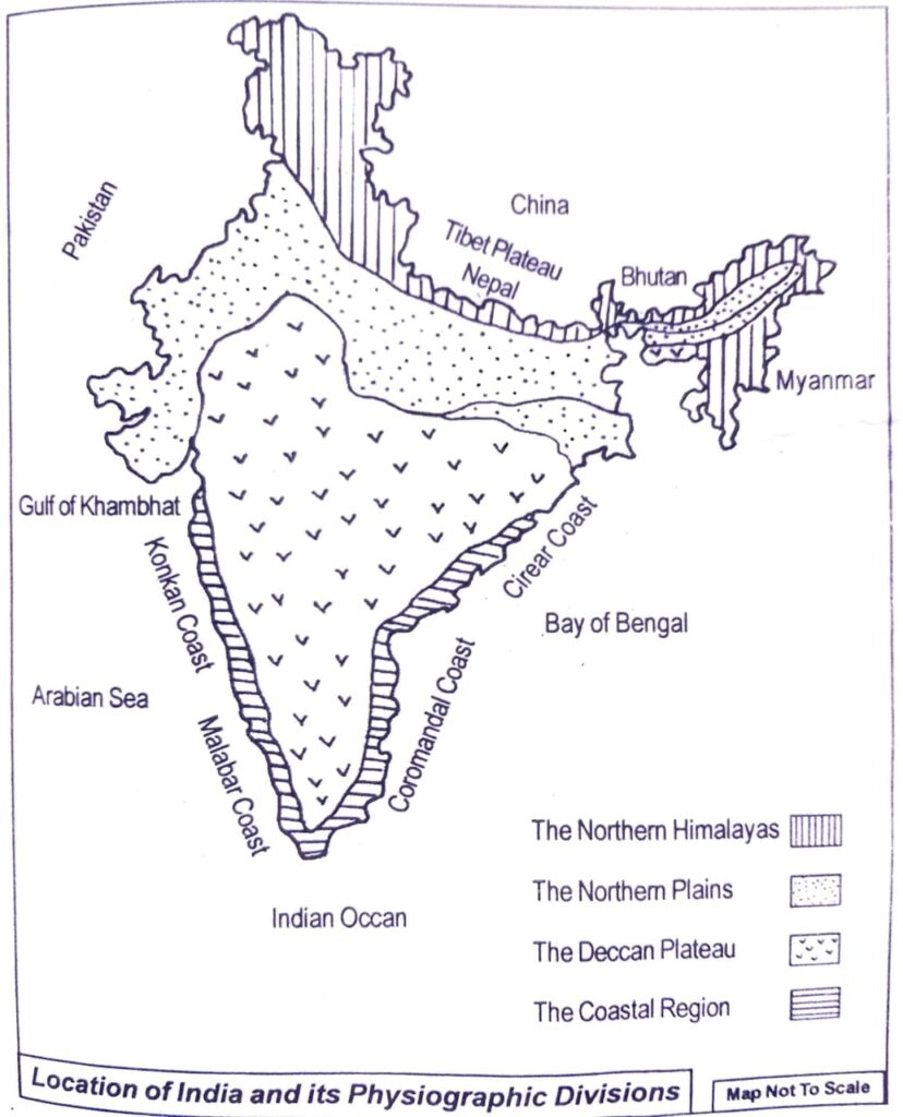
Q.4. Describe the physiographic divisions of India.
Ans: India can be divided into the following four physiographic divisions on the basis of its physiographic characteristics:
(i) The Northern Himalayas: The Himalayan region of India lies in the northern part of India and it extends from Nanga Parbat in Kashmir to Arunachal Pradesh in the east covering a distance of 2,500 km. It has an average width of 240 km to 500 km. The total geographical area of the Himalayas were formed during the Tertiary period and are a result of nearly 7 million years of mountains building process. The Himalayas consists of three parallel ranges running from east to west, namely the higher Himalayas, the lesser Himalayas and the outer Himalayas. Among these three ranges, the higher Himalayas have an average height is 4,000 m. Its width varies from 60 to 80 km. The adjacent ranges of lesser Himalayas are the outer Himalayas. The average height of this range is 1,000 m.
(ii) The Northern Plains: The northern plain lies between the Himalayas in the north and the Deccan plateau in the south. It extends from Assam in the east to the Indo-Pakistan border in the west with a length of 2,400 km and width ranging from 240 km to 320 km. This vast plain is known as Indo- Ganga- Brahmaputra plain.
The northern plain can be divided into five parts:
(a) Western plain.
(b) Punjab-Haryana plain.
(c) North Bengal plain.
(d) North Bengal plain.
(e) Brahmaputra.
The three main rivers, namely the Indus, the Ganges and the Brahmaputra with their innumerable tributaries together created this vast plain. Among these rivers, the most important river is Ganges which originates from the Gangotri glacier of the higher Himalayas while the Brahmaputra originates from a glacier called Chema-yu-Dung located in the Tibetan plateau of China. The most important tributaries of the Ganges are Alakananda, (Yamuna), Ram Ganga, Gomti, Ghagra, Gandak, Son, Kishi, etc. while the main tributaries of the Brahmaputra are Subansuri, Jia Bharali, Dhansiri (north), Dhansiri (south), Puthimari, Manas, Burhi Dihing, Disang, Dikhow, Kapili, Krishnai, etc. The important tributaries of Indus are Sutlej, Beas and Ravi rivers. Towards the west of the central plain, there is a small desert named the Thar desert. The entire plain is very fertile and highly suitable for agriculture. Hence, this region is thickly populated.
(iii) The Deccan plateau: is situated to the south of the north Indian plain. This plateau mostly consists of the old hard rocks. The Vindhya. Satpura, Mahadev and Mahakal mountains divide the whole region into northern and southern parts. The northern part is less extensive and extends from the Vindhya-Satpura ranges to Cape Comorin. The Deccan plateau on the whole slopes towards the east and so most of the rivers of this region such as Mahanadi, Godavari, Krishna, Pennar and Kaveri flow eastwards into the Bay of Bengal while Narmada and Tapti flow towards west and empty themselves in the Gulf of Cambay (Khambhat).
(iv) The coastal region: There is a strip of coast of India. The narrow strip of area lying between the western coast of India. The narrow strip of area lying between the Western Coastal plain. Its northern part is called Konkan Coast while the southern part is known as Malabar Coast. The area lying between the Eastern Ghats and the Bay of Bengal is known as the Eastern Coastal plain. The southern part of this coast is called Coromandel Coast while the northern part is known as Northern Circars. The eastern coastal region is watered by rivers such as Godavari, Mahanadi, Krishna and (Kaveri). It is not as fertile as the western coastal plain. The rivers of this area have deltas.
Q.5. Describe briefly the climatic characteristics of India.
Ans: Characteristics of the Indian Climate: India has the climate of Tropical monsoon due to its peculiar position in the Asian continent and the Indian Ocean. Indian climate is mostly characterized by wet and dry seasons. However, some locations within India like Ladhak and Thar desert do not have wet seasons. The mean rainfall in each region in India varies While Meghalaya records one of the highest rainfalls while Jaisalmer records the least. The Ganga plains and coastal regions receive rainfall during July and August. The coromandel region is dry during these months. During the months of June and July places like Goa, Patna, and Hyderabad receives rainfalls along with regions in the Northwest.
In India, diurnal and annual temperatures have substantial ranges. Thar experience the highest diurnal temperatures while the Himalayas experience the highest annual temperatures. Coastal regions have lower annual and diurnal temperatures. The Indian subcontinent has hot summers and moderately cold winters. In the Himalayas, winters are extremely cold while summers are moderately hot.
Q.6. Explain how the monsoons affect the climate of India.
Ans: (i) The controls affecting the climate of India are: latitude, altitude, pressure and wind system, distance from the sea, ocean currents and relief features.
(ii) The climate of India is strongly influenced by monsoon winds. Hence, it has a monsoon type of climate.
(iii) The north-western part of India comprising the Indian Desert experiences the highest diurnal range of temperature. This is because of the fact that sand (found in ample quantity in this region) gains and loses heat very quickly. As a result of this phenomenon, there is a wide difference between day and night temperatures in this region. The day temperature may rise to 50°C and drop down to near 15°C the same night.
(iv) The south-west monsoon winds are responsible for rainfall along the Malabar Coast.
(v) Jet streams are a narrow belt of high-altitude winds in the troposphere. The sub-tropical westerly jet stream blowing south of the Himalayas are responsible for the western cyclonic disturbances experienced in the north and north-western parts of the country during the winter months. The sub-tropical easterly jet stream blowing over peninsular India is responsible for the tropical cyclones that affect the eastern coastal regions of India during the monsoon as well as during the October to November period.
(vi) Monsoon refers to the complete reversal of winds over a large area leading to a change of seasons.
“Break” in monsoon refers to the wet and dry spells of the monsoon. In other words, the monsoon rains take place for a few days at a time. They are interspersed with rainless intervals.
(vii) Despite variations in temperature conditions across India, a sense of unity is imposed by the monsoon. The seasonal alteration of the wind systems and the associated weather conditions provide a rhythmic cycle of seasons that binds the entire country.
Q.7. What are the major soil types found in India? Give short description of each type of soil.
Ans: Different Types of Soil in India:
(i) Alluvial Soil.
(ii) Black Cotton Soil.
(iii) Red & Yellow Soil.
(iv) Laterite Soil.
(iv) Mountainous or Forest Soil.
(v) Arid or Desert Soil.
(vi) Saline and Alkaline Soil.
(vii) Peaty and Marshy Soil.
(i) Alluvial Soil: The alluvial soil is a commonly found soil that mainly occurs in the Satluj- Ganga- Brahmaputra Plains. The alluvial soil is also found in valleys of the Narmada, Tapi, and the Eastern and Western coastal plains. This soil is poorly drained and well-drained with an immature profile in undulating areas.
(ii) Black Cotton Soil: Black cotton soil is clayey in nature and is widely used for the purpose of agriculture. It has high water retention capacity as it is deep and impermeable in nature. The black color of the black soil is due to the presence of aluminum compounds, iron, and humus.
(iii) Red & Yellow Soil: The red colour is due to the presence of iron in crystalline and metamorphic rocks. The soil appears yellow when it is in hydrated form. The fine-grained red and yellow soil is usually fertile while the coarse-grained soil is less fertile. This type of soil is generally deficient in nitrogen, phosphorus and humus.
(iv) Laterite Soil: Laterite is a soil type rich in iron and aluminium and is commonly considered to have formed in hot and wet tropical areas. Nearly all laterites are of rusty-red coloration, because of high iron oxide content.
(iv) Mountainous or Forest Soil: Forest and mountain soils occur not only at higher elevations, but also at lower elevations that have sufficient rainfall. They are formed by the deposition of organic matter derived from forest growth and are heterogeneous in nature, depending on parent rocks, ground configuration, and climate.
(v) Arid or Desert Soil: Arid or desert soil is among the most common soil categories worldwide. They have a sandy structure and are saline in character. The soil ranges from red to brown colors.
(vi) Saline and Alkaline Soil: Saline soils are mostly made up of soluble salts. Alkali soils have a lot of sodium accumulated on them. However, because of prior leaching, it may not necessarily contain an overabundance of soluble salt. Therefore, they are classified as saline-alkali or non-saline-alkali soils based on their salt concentration.
(vii) Peaty and Marshy Soil: Peaty and Marshy soil is found in the wet, humid regions like river deltas and marshlands. The soil has a large amount of decomposing organic matter, giving it a black colour. Peaty soil is mostly submerged during the monsoon season, which is the reason this soil is used for paddy cultivation.
Q.8. What are the different vegetation types found in India? Mention them on a map.
Ans: The different vegetation types found in India are:
(i) Evergreen vegetation.
(ii) Monsoonal vegetation.
(iii) Dry thorny vegetation.
(iv) Grassland vegetation.
(v) Mangrove vegetation.
(vi) Mountain vegetation.
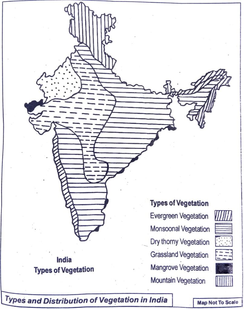
Q.9. Describe the types of vegetation of India.
Ans: Types of Natural Vegetation in India:
(i) Evergreen vegetation.
(ii) Monsoonal vegetation.
(iii) Dry thorny vegetation.
(iv) Grassland vegetation.
(v) Mangrove vegetation.
(vi) Mountain vegetation.
(i) Evergreen vegetation: evergreen, any plant that retains its leaves through the year and into the following growing season. Many tropical species of broad-leaved flowering plants are evergreen, but in cold-temperate and Arctic areas the evergreens commonly are cone-bearing shrubs or trees (conifers), such as pines and firs.
(ii) Monsoonal vegetation: Monsoon forest, also called dry forest or tropical deciduous forest, open woodland in tropical areas that have a long dry season followed by a season of heavy rainfall. The trees in a monsoon forest usually shed their leaves during the dry season and come into leaf at the start of the rainy season.
(iii) Dry thorny vegetation: Dry thorny vegetation grows in the regions where average annual rainfall is less than 50 cm and temperature is normally high. Since the soil is sandy and water content in soil is less, the trees have thorny leaves to check evapotranspiration. The western part of the Thar desert of Rajasthan and south-western parts of Punjab have this type of vegetation. The major trees of dry lands and desert regions include acacia, different varieties of cactus, date, palm, etc.
(iv) Grassland vegetation: grassland, area in which the vegetation is dominated by a nearly continuous cover of grasses. Grasslands occur in environments conducive to the growth of this plant cover but not to that of taller plants, particularly trees and shrubs. The factors preventing establishment of such taller, woody vegetation are varied.
(v) Mangrove vegetation: Mangroves are a special type of vegetation. And they are found in the intertidal regions where freshwater and saltwater intermixes, in the bays, estuaries, creeks, and lagoons. They are the salt-tolerant variety of plants, which can survive in harsh conditions. And they are economically and ecologically significant.
(vi) Mountain vegetation: Mountain vegetation is found on the mountains at higher altitudes (heights). This kind of vegetation differs according to variation and increase in altitude. As the height increases, the temperature decreases. Thus, trees at a higher altitude are conical and form the coniferous forests.
Q.10. Write a short note on the growth of population in India.
Ans: Since the first Indian Census in 1871, India has recorded a massive growth in population. Currently, India is the world’s second-most populist country with 121 crore people. This rapid growth of population in India was characterised by rapid urbanisation and a decrease in the average age of the general population, making India one of the world’s youngest nations. The phases of population growth can be classified into four distinct phases of growth
1891-1921 – phase of stagnant growth
1921-1951 – phase of steady growth
1951-1981- Phase of population explosion
1981- 2011 (scheduled 2021 census was postponed due to the pandemic) – phase of steadying of population
Along with the population explosion and growth, there also existed lots of variation in the said growth of the population. The population in northern states seemed to continue to grow rapidly whereas southern states like Goa, Kerala, Tamil Nadu ranking high on the HDI controlled the population explosion. Along with the growth in population it was accompanied with other challenges and problems of adolescents like that of skill training of the youth, provision of nutrient food for the infants, employment opportunities for the growing youth etc.
Phase (i)- 1891-1921: The phase from 1891 to 1921 can be characterised as the first phase of population growth.
During this phase, the population of the country grew from 23.6 crores in 1891 to 25.1(a growth of just 0.19%) crores in 1921. Due to the stagnant and sluggish growth of the population during this phase, this phase of the population growth is referred to as the “Stagnant population” phase.
One of the main reasons for such dismal growth in the population was the lack of health infrastructure and services. This phase witnessed a ballooning birth rate of 47 births per 1000 population but the death rates were equally high 45 deaths per 1000 population. The Infant Mortality rate too was at its peak of 218 deaths per 1000 births. The lethargic approach of the British administration towards health services in India made the administration incapable of tackling various epidemic outbreaks like that of the infamous plague in the 1890s or the Spanish flu in the 1920s which left millions dead.
Phase (ii) – 1921- 1951: This phase of population growth from 1921-1951 is referred to as the “Steady Growth” period. During this period population increased from 25.1 crores in 1921 to 36.1 crores in 1951, a growth of 11 crores or a CAGR of 1.22% which is considered to be a moderate growth rate. This phase witnessed a transition of Indian demographics into a new era, which was resultant of the socio-political changes which were taking place in the country.
The birth rates per 1000 population remained stable to 42, but the death rates saw a massive fall from 45 per 1000 population to 27 per 1000 population.. Improvement in the health infrastructure of the country and successful attempts by the administration to control the epidemics and outbreaks contributed a lot in bringing down the death rates during this phase.
During this phase, India had entered into the second stage of demographic transition, which entails high birth rates while the death rates continue to subside.
Phase (iii) – 1951-1981: During the third 30 year phase, India’s population almost doubled from 36.1 crores to 68.3 crores, with a CAGR of 2.14%. This was the sharpest jump in the growth rate of the Indian population, thus this phase is regarded as the “Rapid High Growth” phase. There was a record growth of the Indian population by 32 crores, which was almost 3 times the growth in the previous phase.
The third phase of the demographic transition is characterised by falling birth rates and a steep fall in the death rates, leading to higher net addition to the population. During this phase of population growth, India’s birth rate declined from 42 per 1000 population to 32 per 1000 population, while the death rate came down from 27 per 1000 population to 15 per 1000 population
With the help of various government measures, schemes and programs related to family planning, health and welfare, health infrastructure casualties and death incidences in the country were kept in check. It was also in this phase that India began to develop and work on various mass vaccination programs, which furthered the cause of reducing death rates. And as all this while birth rates constantly remained high, it led to a massive explosion in the country’s population.
Phase (iv) – 1981-2011: The final stage of demographic transition includes falling birth rates and low death rates leading to steadying up of the population. But as the birth rates are much higher than the death rates, the nation’s population continued to grow from 68.3 crores in 1981 to 121 crores in 2011, a growth of 77% in total. This phase is referred to as a “high growth stage with definite signs of slowing down”. During the 1991-2001 decade population grew from 84.4 crores to 100.2 crores, and from 2001-2011 it went up from 100.2 crores to 121 crores a growth of 18.1 crores
This phase also witnessed a steady continuous fall in the birth rate from 32 per 1000 to 22 per 1000. Along with the birth rates, the death rates too came down to 7 per 1000 population. The main reason for such phenomenal statistics was the growth of the Indian Economy post the 1991 reforms.
Q.11. “Population distribution is not uniform in all places of India”. — Explain.
Ans: India is the second most populous country in the world with a population of 102.7 crores according to 2001 census. The average density of population of India is 324 persons per sq. km. However, this density of population varies from place to place. For example, Delhi has a density of population 6,352 persons per sq. km. (2001 census) while Arunachal Pradesh has only 13 persons per sq. km. Uttar Pradesh has over 16.6 crores of people while Lakshadweep has about 60,000 people only. Thus, we see that the population distribution is not even in India.
The primary reasons for the uneven distribution of population in India are:
(i) Difference in relief conditions: The size of population of a place is greatly affected by the relief conditions of the place. The river valleys with alluvial plains have high population because of the possibility of agriculture, human settlement and better transport and communication facilities. On the other hand, hilly regions with little scope for agriculture and transport facilities have less population.
(ii) Variation in climate: Climate exerts a great impact on the population distribution. Desert regions of Rajasthan have low population while Ganga plain has high population mainly because of the difference in climate. Extreme hot and cold climatic conditions and no rainfall discourage human settlement and economic activities in the plains of Rajasthan.
(iii) Influence of soil: Scope for agriculture depends on soil conditions. The alluvial soil of the river valleys and the black soil of Deccan plateau are ideal for cultivation of rice and wheat respectively. Hence, these regions are thickly populated. The mountain soil is not very good for agriculture. Hence, the population density is thin in the mountainous region.
(iv) Influence of rivers: Rivers valleys have high population distribution mainly because of the availability of water for domestic and industrial purposes. Such regions are also best suited for the development of agriculture which in turn encourages human settlement. That is why river valleys are considered to be cradles of civilization.
(v) Presence of minerals: Availability of mineral resources help the industrialisation of an area. Industrialisation brings about a lot of job opportunities. Hence, the major industrial regions of India are thickly populated.
(vi) Religious influence: Religious places like Varanasi, Mathura, Haridwar, Puri, etc. have thick population as many people like to settle in such holy places.
(vii) Transport and communication facilities: The population distribution is quite high in places that have better or modern transport and communication facilities. This is one of the major reasons for the presence of high population in towns and cities as compared to rural areas.
Q12. Discuss how population density varies in India.
Ans: One of the features of Indian population is its uneven population distribution. Certain regions of India are thickly populated while other areas are thinly populated. But if we look at India as a whole, the average density of the population is 324 persons per sq. km, i.e. 324 persons live on per sq. km while Arunachal Pradesh has only 13 persons per sq.km. Uttar Pradesh with a population of 16.6 crores is the most populous state of India while the total population of Lakshadweep islands adds up to just 60,000 people. Some of the densely populated states and union territories of India are West Bengal, Delhi, Chandigarh, Kerala, Daman and Due, Pondicherry (present Puducherry), etc. The areas that have a low density of population are Himachal Pradesh, Jammu and Kashmir, Meghalaya, Nagaland, Manipur, Sikkim, Arunachal Pradesh, Mizoram and Andaman and Nicobar islands.
The factors that cause differences in the density of population of India are:
(i) Relief conditions.
(ii) Variations in climate.
(iii) Soil differences.
(iv) Availability of transport and communication.
(v) State of economic and industrial development, etc.
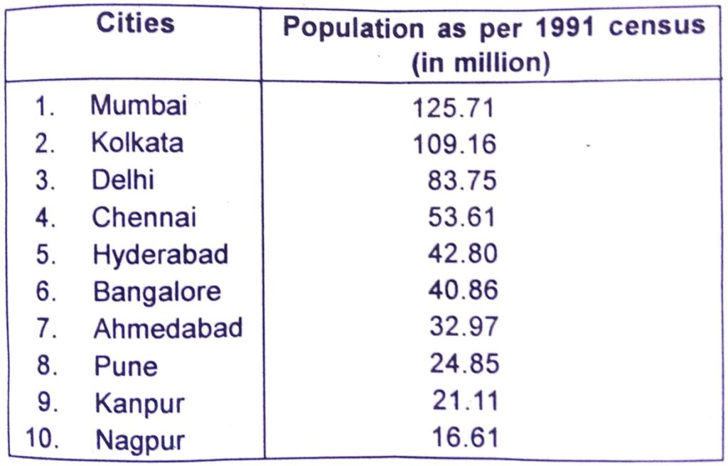
Q.13. Give a description of urban population of India and also present data on urban population growth in some major cities of the country.
Ans: The density of population in the towns and cities of India is quite high. Easy transportation facilities, high industrial development, urban facilities, better employment opportunities, etc. encourage people to settle down in cities and towns. Thus, a good number of Indian population lives in the urban centres. The urban population of India was 25.7% according to 1991 census. In other words, 74.3% of the Indian population lives in the rural areas. Along with the general increase in the size of the population of India, the urban population has also been increasing at a rapid rate. A cursory look at the growth of cities and townships in India during the last few decades will substantiate this point. In 198 there were about 3,245 towns and cities in India which number rose to 3,768 in 1991.
Today, there are 13 cities with over one million population. The most populous cities of India are Mumbai, Kolkata, Delhi and Chennai. According to 1991 census, the population Mumbai was 125.71 million which was followed by Kolkata with a population of 109.16 million. The size of the urban population in almost all the states has been increasing at a rapid rate as a result of the economic advancement achieved by India. The industrial development and economic growth achieved by India during the recent decades has boosted the growth of her towns and in 1991 this number went up to 87. Guwahati is the largest town in Assam. According to 1991 census, the population of Guwahati was 5.84 lakhs. About 23.5% of the total urban population of Assam lives in the city of Guwahati alone.
The first ten cities of India on population size:
Q.14. Describe the characteristics of the major agricultural regions of India.
Ans: There are major characteristics of the Indian agriculture:
(i) Source of livelihood: Agriculture contributes to about 25% of our total national income. The main occupation of the Indian economy is agriculture.61% people of the total population get employment from it.
(ii) Dependence on monsoon: Monsoon is the main thing on which the agriculture of India depends upon. If there is a good amount of rain i.e. the monsoon is good then the crop production would also be more in quantity and if the monsoon does not sum up well then the crops fail to grow. Sometimes too much rain resulting in floods causes a great amount of destruction to our crops. Due to the inadequate irrigation facilities, agriculture depends upon the monsoon.
(iii) Labour-intensive cultivation: The population is increasing with every passing day which in turn puts increasing pressure on land. The landholdings are getting shattered and subdivided which becomes uneconomical. These farms do not allow the pieces of equipment and machinery to be used on them.
(iv) Underemployment: The uncertain amount of rainfall and inadequate irrigation facilities leads to decreasing agricultural production. The farmers get to work only a few months in the whole of the year. Their work capacity is not properly utilised. This in turn causes distinguished unemployment as well as underemployment.
Q.15. Locate the major industrial regions of India in a map and describe each of them briefly.
Ans: India has several industrial regions like Mumbai- Pune cluster, Bangalore-Tamil Nadu region, Hugli region, Ahmedabad-Baroda region, Chottanagpur industrial belt, Vishakhapatnam-Guntur belt, Gurgaon-Delhi-Meerut region and the Kollam Thiruvanathapuram industrial cluster.
The Industrial region are discussed below:
Industrial Regions in India
- Hooghly industrial region
- Mumbai-Pune industrial region
- Bangalore-Chennai Industrial Region
- Gujarat Industrial Region
- Chotanagpur industrial region
(i) Hooghly industrial region: It extends from Bansberia in the north to Birlanagar in the south for a distance of about 100 km along the Hugli River. Industries also has developed in Mednipur in the west. Kolkata-Haora from the nucleus of this industrial region. Kolkata emerged as a leading centre of the country. Later, Kolkata was connected with interior parts by railway lines and road routes. Development of tea plantations in Assam and northern hills of West Bengal, the processing of indigo earlier and jute later coupled with the opening of coalfields of the Damodar Valley and iron ore deposits of the Chotanagpur plateau, contributed to the industrial development of the region. Cheap labour available from thickly populated part of Bihar, eastern Uttar Pradesh and Orissa also contributed to its development.
Cotton textile industry also grew along with jute industry, paper, engineering, textile machinery, electrical, chemical, pharmaceuticals, fertiliser and petrochemical industries have also developed within this region. Important industrial centres of this region are Kolkata, Haora, Haldia, Serampur, Rishra, Shibpur, Naihati, Kakinara, Shamnagar, Titagarh, Sodepur, Budge Budge, Birlanagar, Bansberia, Belgurriah, Triveni, Hugli, Belur, etc.
(ii) Mumbai-Pune industrial region: It extends from Mumbai-Thane to Pune and in adjoining districts of Nashik and Solapur. Besides, industrial development has been rapid in Kolaba, Ahmednagar, Satara, Sangli and Jalgaon districts. Development of this region started with the location of cotton textile industry in Mumbai. Mumbai, with cotton hinterland and moist climate favoured the location of cotton textile industry. Hydro-electricity was developed in the Western Ghats region to meet the requirements of this industry. With the development of cotton textile industry, chemical industry also developed. Important industrial centres are Mumbai, Kolaba, Kalyan, Thane, Trombay, Pune, Pimpri, Nashik, Manmad, Solapur, Kolhapur, Ahmednagar, Satara and Sangli.
(iii) Bangalore-Chennai Industrial Region: This region witnessed most rapid industrial growth in post-Independence period. Till 1960, industries were confined to Bangalore, Salem and Madurai districts but now they have spread over all the districts of Tamil Nadu except Viluppuram. Since, this region is away from the coalfields; its development is dependent on the Pykara hydroelectric plant, which was built in 1932. Cotton textile industry was the first to take roots due to the presence of cotton growing areas. Along with cotton mills, loom industry spread very rapidly. Several heavy engineering industries converged at Bangalore. Aircraft (HAL), machine tools, telephone (HTL) and Bharat Electronics are industrial landmarks of this region. Important industries are textiles, rail wagons, diesel engines, radio, light engineering goods, rubber goods, medicines, aluminium, sugar, cement, glass, paper, chemicals, film, cigarette, match box, leather goods, etc. Petroleum refinery at Chennai, iron and steel plant at Salem and fertiliser plants are recent developments.
(iv) Gujarat Industrial Region: The nucleus of this region lies between Ahmedabad and Vadodara but this region extends upto Valsad and Surat in the south and to Jamnagar in the west. Development of this region is also associated with the location of the cotton textile industry since 1860s. This region became an important textile region with the decline of the cotton textile industry at Mumbai. Located in cotton growing area, this region has double advantage of the proximity of raw materials as well as of market. The discovery of oil fields led to the establishment of petrochemical industries around Ankleshwar, Vadodara and Jamnagar. The port at Kandla helped in the rapid growth of this region. Petroleum refinery at Koyali provided raw materials to a host of petrochemical industries. The industrial structure is now diversified. Besides, textiles (cotton, silk and synthetic fabrics) and petrochemical industries, other industries are heavy and basic chemicals, motor, tractor, diesel engines, textile machinery, engineering, pharmaceuticals, dyes, pesticides, sugar, dairy products and food processing. Recently, largest petroleum refinery has been set up at Jamnagar. Important industrial centres of this region are Ahmedabad, Vadodara, Bharuch, Koyali, Anand, Khera, Surendranagar, Rajkot, Surat, Valsad and Jamnagar.
(v) Chotanagpur industrial region: This region extends over Jharkhand, northern Orissa and western West Bengal and is known for the heavy metallurgical industries. This region owes its development to the discovery of coal in the Damodar Valley and metallic and non-metallic minerals in Jharkhand and northern Orissa. Proximity of coal, iron ore and other minerals facilitated the location of heavy industries in this region. Six large integrated iron and steel plants at Jamshedpur, Burnpur- Kulti, Durgapur, Bokaro and Rourkela are located within this region. To meet the power requirement, thermal and hydroelectric plants have been constructed in the Damodar Valley. Densely populated surrounding regions provide cheap labour and Hugli region provides vast market for its industries. Heavy engineering, machine tools, fertilisers, cement, paper, locomotives and heavy electrical are some of the important industries in this region. Important centres are Ranchi, Dhanbad, Chaibasa, Sindri, Hazaribag, Jamshedpur, Bokaro, Rourkela, Durgapur, Asansol and Dalmianagar.
Q.16. Write short notes on the following:
(a) The north Indian plain region.
(b) Importance of agriculture in Indian economy.
(c) Monsoon vegetations.
(d) Monsoons and rainfall in India.
(e) Causes of population growth in India.
(f) Causes responsible for uneven distribution of population in India.
(g) Lava soils.
(h) Hooghly industrial region.
(i) Characteristics of the north India rivers.
(j) Characteristics of the south Indian rivers.
(k) Indian islands.
(I) The Himalayan mountain region.
Ans: The north Indian plain region: The Northern plain of India runs for roughly 2400 kilometres from west to east, and from north to south, it stretches for 240 to 320 kilometres. . In some parts, the depth of the sediments is as much as 2000 to 3000 metres. Indus, Ganga and Brahmaputra are the major rivers of Northern Plains of India.
(b) Importance of agriculture in Indian economy: Agriculture is an important sector of Indian economy as it contributes about 17% to the total GDP and provides employment to over 60% of the population. Indian agriculture has registered impressive growth over last few decades.
(c) Monsoon vegetation: Monsoon forest, also called dry forest or tropical deciduous forest, open woodland in tropical areas that have a long dry season followed by a season of heavy rainfall. The trees in a monsoon forest usually shed their leaves during the dry season and come into leaf at the start of the rainy season.
(d) Monsoons and rainfall in India: The summer monsoon is associated with heavy rainfall. It usually happens between April and September. As winter ends, warm, moist air from the southwest Indian Ocean blows toward countries like India, Sri Lanka, Bangladesh, and Myanmar. The summer monsoon brings a humid climate and torrential rainfall to these areas. Monsoons always blow from cold to warm regions. The summer monsoon and the winter monsoon determine the climate for most of India and Southeast Asia.
(e) Causes of population growth in India: High birth rates and lower death rates cause an increase in population. If birth rate remains the same and death rate increases, the population will reduce in size. If birth rate increases and death rate remain the same, the size of the population will increase in size.
(f) Causes responsible for uneven distribution of population in India: India, has uneven distribution of population due to several factors like.
(a) Low birth and high death rates areas.
(b) Topography Rugged terrain and unfavorable climatic conditions are primarily responsible for. sparse population in states like Rajasthan and the hill states.
(c) Hilly, dissected and rocky nature of the terrain, moderate to low rainfall, shallow and less fertile soil are responsible for lesser population.
(g) Lava soils: Black soils are made up of volcanic rocks and lava-flow. It is concentrated over Deccan Lava tracts which includes parts of Maharashtra, Chhattisgarh, Madhya Pradesh, Gujarat, Andhra Pradesh and Tamil Nadu.
(h) Hooghly industrial region: It extends from Bansberia in the north to Birlanagar in the south for a distance of about 100 km along the Hugli River. Industries also has developed in Mednipur in the west. Kolkata-Haora from the nucleus of this industrial region. Kolkata emerged as a leading centre of the country. Later, Kolkata was connected with interior parts by railway lines and road routes. Development of tea plantations in Assam and northern hills of West Bengal, the processing of indigo earlier and jute later coupled with the opening of coalfields of the Damodar Valley and iron ore deposits of the Chotanagpur plateau, contributed to the industrial development of the region. Cheap labour available from thickly populated part of Bihar, eastern Uttar Pradesh and Orissa also contributed to its development.
Cotton textile industry also grew along with jute industry, paper, engineering, textile machinery, electrical, chemical, pharmaceuticals, fertiliser and petrochemical industries have also developed within this region. Important industrial centres of this region are Kolkata, Haora, Haldia, Serampur, Rishra, Shibpur, Naihati, Kakinara, Shamnagar, Titagarh, Sodepur, Budge Budge, Birlanagar, Bansberia, Belgurriah, Triveni, Hugli, Belur, etc.
(i) Characteristics of the north India rivers: Some characteristics of North Indian rivers are:
1. They are perennial , i.e. they carry water throughout the year.
2. These rivers receive water from both glaciers and rain.
3. These rivers originate from the Himalayan range.
4. These rivers generally have a long path from their origin to their end , i.e. they are long.
(j) Characteristics of the south Indian rivers: The important south Indian rivers are Narmada, Tapti, Mahanadi, Godavari, Krishna and Kaveri. Narmada and Tapti flow westwards and empty themselves into the Gulf of (Khambhat) while all other Deccan rivers flow eastwards and empty themselves in the Bay of Bengal.
The important characteristics of these rivers are:
(i) The rivers of the Deccan originate in plateaus and low hills of the region. They are fed by rains. Therefore, most of these rivers are seasonal and become dry during the dry season.
(ii) These rivers are much older than their counterparts in the north.
(iii) These rivers are relatively shorter in length.
(iv) They carry less water and sediments than the northern rivers.
(v) There are no distinct upper, middle and lower courses.
(vi) These rivers do not change their courses.
(vii) The river valleys created by the Deccan rivers are not very suitable for agriculture.
(viii) The river basins of the Deccan rivers are not very suitable for agriculture.
(ix) These have small deltas or no deltas.
(x) These are highly suitable for power generation.
(xi) Only few towns are situated on the banks of the Deccan rivers.
(xii) Indian islands:India has two groups of islands. One group of islands is in the Arabian Sea and the other group of islands are in the Bay of Bengal.
Andaman and Nicobar of Islands
- Andaman and Nicobar islands are located in the Bay of Bengal.
- These islands are scattered, numerous islands come under this group of islands and these islands are bigger in size.
- This entire group of islands are divided into two broad groups, they are Nicobar in the South and Andaman in the North.
- These islands have very high strategic importance for India, as they are located near Malacca strait which connects Indian Ocean and South China Sea.
- These groups of islands have great flora and fauna.
- These islands have thick forest cover, it has an equatorial climate.
- These islands are close to the equator.
Lakshadweep Islands
- Small coral islands constitute the Lakshadweep Islands.
- These groups of islands were known as the Laccadive, Minicoy and Amindive.
- These islands were later renamed as Lakshadweep Islands in 1973.
- Bird sanctuary is located in Pitti Island. It is uninhabited.
- Lakshadweep Islands are rich in flora and fauna.
- The administrative headquarters of Lakshadweep Islands are located in Kavaratti Island.
- Lakshadweep Islands are much smaller in size when compared to Andaman and Nicobar Islands.

Hi, I’m Dev Kirtonia, Founder & CEO of Dev Library. A website that provides all SCERT, NCERT 3 to 12, and BA, B.com, B.Sc, and Computer Science with Post Graduate Notes & Suggestions, Novel, eBooks, Biography, Quotes, Study Materials, and more.
