Class 10 Elective Geography Chapter 3 Concept of Region and Regional Geography of The World Question answer to each chapter is provided in the list so that you can easily browse throughout different chapters Assam Board HS Class 10 Elective Geography Chapter 3 Concept of Region and Regional Geography of The World and select needs one.
Class 10 Elective Geography Chapter 3 Concept of Region and Regional Geography of The World


Also, you can read the SCERT book online in these sections Solutions by Expert Teachers as per SCERT (CBSE) Book guidelines. These solutions are part of SCERT All Subject Solutions. Here we have given Assam Board Class 10 Geography Elective Chapter 3 Concept of Region and Regional Geography of The World Solutions for All Subject, You can practice these here.
Concept of Region and Regional Geography of The World
Chapter : 3
Textual Questions And Answers
Q.1. What do you mean by a region? Explain the importance of region in geographical study.
Ans: A region is an area. A region can be geographic — like a part of a country. A region can be intellectual — like a region of the mind. There are also bodily regions — like abdominal, thoracic, and posterior.
In geography, regions are areas which have certain and definable traits in common. These characteristics can be either natural or artificial and a region can be either large or small. A naturally characterized region shares similarities in terms of climate, landscape, and wildlife, for instance, while artificial characteristics include the shared religion, government, or language. Geographers group these places into regions because of the shared traits, but due to the constantly shifting nature of natural and artificial boundaries, a region is always changing.
Geographical regions can also be referred to as geographical areas, districts, and locales. Regions do not necessarily have a specific boundary, but sites within a region may. For example, the Middle East is a region of southwestern Asia. This region is defined by its natural similarities of dry and arid climates and artificial similarities of governmental and political structures. There is no clear boundary for the region of the Middle East, but the countries of Syria, Saudi Arabia, and Libya all have defined borders.
Within a geographical context, regions exist all over the world. They vary based on the conditions found within, whether those may be human-based or terrestrial. Some examples of famous regions around the world include:
The Amazon is a region in South America made up of land surrounding the Amazon River.
The Pacific Northwest is part of the United States, a region with a generally wet and cool climate.
Latin America is a cultural region consisting of people who speak a Latin-based language.
Q.2. Explain how a region can be identified on the earth’s surface.
Ans: Five main latitude regions of the Earth’s surface comprise geographical zones, divided by the major circles of latitude. The differences between them relate to climate.
They are as follows:
1. The North frigid zone, between the Arctic Circle 66.5° N and the North Pole 90° N. Covers 4.12% of Earth’s surface.
2. The North temperate zone, between the Tropic of Cancer 23.5° N and the Arctic Circle 66.5° N. Covers 25.99% of Earth’s surface.
3. The Torrid zone, between the Tropic of Cancer 23.5° N and the Tropic of Capricorn 23.5° S. Covers 39.78% of Earth’s surface.
4. The South temperate zone, between the Tropic of Capricorn 23.5° S and the Antarctic Circle 66.5° S. Covers 25.99% of Earth’s surface.
5. The South frigid zone, from Antarctic Circle 66.5° S and the South Pole 90° S. Covers 4.12% of Earth’s surface.
On the basis of latitudinal extent, the globe is divided into three broad heat zones:
1. Torrid Zone
2. Temperate Zone
3. Frigid Zone
Q.4. What do you mean by regional geography of the world? What is the importance of this study?
Ans: Regional geography of the Earth is the regional study of elements in the natural environment. There are some regional similarities in the natural components of the Earth’s surface. Regional geography is the overall study of the geography of each region of the world.
The study of regional geography of the world is of great significance and importance. To know the overall state of a continent , country or state, it is necessary to study carefully every component of its natural and human environment and the relationships between them. Regional studies provide information on the socio-economic development of a country or region and the problems associated with it. Various development plans are prepared by geographical study of the natural and socio-economic characteristics of an area. Therefore, it is especially important to study the regional geography of the world in order to gain regional knowledge of a region of the world. Therefore, the study of regional geography of the world is increasingly important.
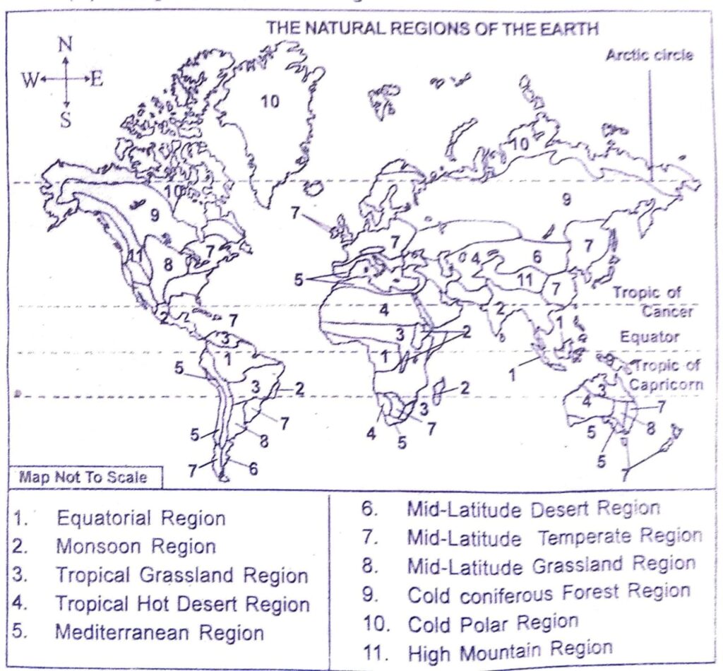
Q.5. What do you mean by ‘natural region’? Into how many natural regions, the whole earth can be divided? Write their names and show in the map.
Ans: Natural regions are areas of the Earth’s surface that have almost the same topography, climate, natural vegetation and soil properties. In other words, parts of the Earth that are affected by similar natural systems and consequently human activities are called natural regions.
The entire world can be divided into eleven natural regions based on the characteristics of the climate and natural vegetation.
They are –
(i) Equatorial region.
(ii) Monsoon region.
(iii) Tropical grassland region.
(iv) Tropical hot desert region.
(v) Mediterranean region.
(vi) Mid-latitude desert region.
(vii) Mid-latitude temperate region.
(viii) Mid-latitude grassland region.
(ix) Cold coniferous forest region.
(x) Cold polar region.
(xi) High mountainous region.

Q.6. How can the regional geography of the world be understood through the study of natural regions? Write in brief.
Ans: Knowledge about the regional geography of the world can be gained through the study of natural regions. Depending on the natural environment some parts of the world are mainly made agricultural and some other areas are industrial areas. In order to know about the overall condition of a continent country or state it is important to seriously study every element of the natural and human environment and the relationship between them.
Based on the similarities in the natural environment several natural regions are identified on the earth and various development schemes are prepared through the geographical study of the natural and socio-economic characteristics of a single natural region. Every natural region is filled with different geographical elements and the study of natural regions is of greater importance in order to gain knowledge about the regional geography of the world. The climate of different natural areas varies in temperature rainfall snowfall etc. Through the study of natural regions, one can easily find out the variation in the elements from region to region and a conclusion can be reached.
Q.7. Write about the physical environment of each of the natural regions of the world.
Ans: The geo-natural environment of every natural region of the world is discussed below:
(a) The climate of the equatorial natural region is warm and humid. The summer and winter variation is very less as sunlight falls perpendicular to this region. The average temperature in the region is 27°C and the average annual rainfall is 200 cm. The area is filled with evergreen thick forests and small bouquets.
(b) The main features of the climate of the monsoon region are seasonal changes i.e. warm and humid summers and cold and dry winters. The difference in heat between summer and winter is 15°C and the annual rainfall averages of 200 centimetres. Rainfall varies with the change of season in this region so more deciduous plants are seen in such areas.
(c) The main feature of the climate of tropical grasslands is warm and short summers and dry and long winters. Temperature varies more daily and seasonally in such areas. The annual rainfall in this region is moderate i.e. from 25 to 100 centimetres, and it sees tall grasses.
(d) The climate in the tropic hot desert region is always warm and dry. And the temperature of day and night is high there. During the summer the temperature rises to 45°C during the daytime. The region receives 20-25 cm of rainfall annually. Only short grasses and thorny plants are born in the absence of rain in the desert areas.
(e) The geo-natural environment of the Mediterranean region is that the summer here is warm and dry and winter is cold and humid. The region receives rainfall in winter The average height of the year is between 8 and 25°C and the annual rainfall is 25-75 cm. In this area, evergreen short trees and shrubs can be seen.
(f) It is surrounded by high mountains around the desert region of the mid-latitudes. The amount of rainfall in this region is very low and due to the continental location the difference in temperature between summer and winter is more. The region receives some snowfall in the winter.
(g) Cold – heat is less in the temperate regions of the middle latitudes. The summer temperature here averages 15°C and 5° to 10°C in winter. The average rainfall annually ranges between 75 and 150 cm. Winters in this region are very dry. Different types of natural plants are seen here according to the variations in rainfall.
(h) The difference between summer and winter is high in the grasslands of the mid latitudes and there is some amount of rainfall in the summer season in this region. The number of trees in the region is very low due to lack of rain and the onset of winter. The soil of this area is fertile due to abundance of organic matter.
(i) The climate in the cooling saral forest area is somewhat dry and cold. The summer temperature in this region increases to an average of 15°C during the summer season and snow falls due to the drop in temperature during winters. The region receives some amount of rain in the summer season and due to the cold and dry climate it gets evergreen simple forests.
(j) The climate of the cold polar regions is characterized by extremely cold climates. The summer season in this region is short and winter is long and in summer the daytime temperature is between 0-10°C and in winter the temperature drops to -18°C. The rainfall in this region is very low and there is heavy snowfall in winters.
(k) The natural environment of the higher mountainous regions varies from slope of the mountain. The high altitude peaks are always covered with snow because of their low temperature. Different climates are observed within a short distance due to changes in height and slope in this region.
Q.8. Discuss about the climate and vegetation as found in different natural regions of the world.
Ans: The following is a look at the climate and vegetation prevailing in different natural regions of the world:
(i) The climate of the equatorial region is warm and humid in nature. Due to the sun’s rays falling almost perpendicular in this region, the variation in day and night and summer and winter heat is very less. The entire equatorial area is full of evergreen thick forests and there are a variety of creepers along with small bushes.
(ii) The summer climate in the monsoon region is warm and humid and cold and dry in winter. That is, climate change is the main feature of the climate of the monsoon region. The difference between summer and winter heat in this region is 15°C. The deciduous plants are grown in large quantities in the monsoon region. In the winter, due to lack of rain, the leaves of trees and trees fall.
(iii) The climate of tropical grasslands is characterized by warm and short summers and dry and long winters. Temperature varies more daily and seasonally in the tropics. Tall grasses grow in this area and such grasslands are known as Savannah.
(iv) The climate of the tropical warm desert region is always warm and dry. And in such areas the answers of day and night are more. In such a climate short grasses and thorny plants are born in some parts due to lack of rainfall. Palm trees grow in any part of the desert.
(v) The climate of the Mediterranean is warm and dry in the summer and winters are cold and humid. The major plants in the region are evergreen short plants and shrubs.
(vi) The climate of the desert region of the mid latitudes is in summer and winter. It’s different. The variation in temperature is high in summer and winter. The region receives some snowfall in the winter. The amount of trees in this region is very low and the amount of grasses is very low due to very little rainfall.
(vii) The climate of the temperate regions of the middle latitudes is cold and the incidence of jars is low. The climate in the vicinity of the sea is favourable and the amount of rainfall decreases with the increase in distance from the sea. Winters are very dry in this region. In most places of this region, deciduous plants grow and it is evergreen in places where excess rainfall occurs. Along with plants, simple gourd plants can be found in hilly areas.
(viii) Temperature variations are observed between summer and winter in the grasslands of the mid latitudes. The climate in this region is very cool and it is almost like there are almost no trees due to the onset of winter. There are different types of grasslands seen in this area.
(ix) The climate in the cooled plain forest area is somewhat dry and cold. A drop in temperature in winter can lead to snow fall and some amount of rain occurs in the summer. Due to the cold and dry climate this region is home to a large number of evergreen simple forests.
(x) The climate of the beel polar region is extremely cold and summers are short and winters are longer in this region. The rainfall in this region is very low and there is heavy snowfall in winters. Due to the onset of winter special plants will not be born in this area and in any place grasses algae and dhekias are seen to be born.
(xi) The high mountainous region is almost always covered with snow and its climate changes depending on the direction of the wind. Different types of climate and natural vegetation are seen in this region due to changes in height and slope. Trees do not grow due to lack of rainfall in the higher parts of the mountains and dark forests can be seen in some parts under the influence of monsoon climate.
Q.9. Give a description of the lifestyle of the people living in different natural regions of the world.
Ans: Due to extreme heat and rain in the equatorial area, the natural environment of this area is not very suitable for human habitation. Due to such adverse conditions, the livelihood of people in this region is difficult. The population in this area is sarenga. The adivasis live mainly in this area. These people make a living by hunting, fishing, and extracting food from the forests. In some places, jhum cultivation also produces potato crops and bananas.
Agriculture is the main occupation of the people of the monsoon region. In the higher reaches of this region fertile alluvial soil is found in laterite and river valleys as well as in the da-places. Therefore, agricultural production in the river valleys is very high. Due to the hot and humid climate and climate change, this region is suitable for the production of various crops. In addition to paddy, the main crops, wheat, sugarcane, cotton, jute, oilseeds, tea, etc. are cultivated in this region. With the development of science and technology, there has been economic development in this region.
Tropical grassland areas are very suitable for animal husbandry. In most parts of the region, cows, horses, buffaloes, sheep and goats are reared on a commercial basis. Such grasslands are home to various wild animals including tigers, lions, elephants, rhinoceros, zebras, giraffes, deer, etc. So many Adivasis in the region make a living by animal husbandry and hunting. The population in this area is very dense.
They live by collecting food from the nature of the tropical warm polar regions and hunting wild animals. The Bedouins, a non-householder living in the Sahara and Arab regions, make a living by rearing camels, horses, sheep, goats, etc.
Agriculture is the main occupation of the people of the Mediterranean. The plains of this region mainly cultivate wheat, barley, maize, cotton, tobacco, etc. depending on winter rainfall and irrigation. There are different types of wine made here from grapes produced in abundance. The population is also somewhat dense as the climate is mild and healthy.
Parts of the mid-latitude desert area are inhabited by nomadic pastoralists. These people do not have a permanent settlement as they migrate in search of fodder. However, irrigation has made it possible to some extent in the river valley area.
People in the temperate regions of the mid-latitudes live mainly through agriculture. The area is under extensive cultivation and extensive cultivation. Along with agriculture in the region, commercial animal husbandry is also done.
The aborigines of the mid-latitude grasslands live mainly through animal husbandry. Most of the people in this region are Aghari Adivasis. At present, agriculture is grown extensively in the region and on the basis of animal husbandry, dairy industry is built as well as wool is produced from sheep’s hair. The population of this area is very sparse.
People in the cooler plains make a living by hunting animals and collecting forest timber. At present, due to the discovery of some minerals in this region, many industrial centers have come up and people are more or less farming as well as rearing sheep.
Living in this natural region is very difficult due to the extremely cold climate of the cold polar region. Permanent living is not possible here. The Adivasis here live a kind of homeless life. These people somehow enter the stomach by hunting animals and collecting fish from the sea.
The way of life in the hills is very difficult, so the population here is very fragile. Animal husbandry and timber trade is the main occupation of the people of this region. The population in the hills is very thin.
Q.10. How many and what are the continents in the world? Give a brief geographical introduction of each of the continents.
Ans: There are seven continents in the world.
They are—
(a) Asian continent.
(b) African continent.
(c) The continent of Europe.
(d) North American continent.
(e) South American continent.
(f) Continent of Oceania.
(g) Continent of Antarctica.
The following is a brief geographical introduction to each continent—
Asia is the largest continent in the world. The Asian continent is mainly located in the Northern Hemisphere. It extends from 1° north latitude to 78° north latitude in the south and from 25° EAST longitude to 170° west longitude in the east. Broadly the Northern Ocean to the north of the Asian continent; The Bering Strait and the Pacific Ocean to the east; The Indian Ocean to the south; and to the west the Red Sea, the Suez Canal, the Mediterranean Sea, the Caucasus Mountains, the Caspian Sea; The Ural River and the Ural Mountains. The continent is about 8,400 km from north to south and about 9600 km to the east-west. The length of its coast is about 58,000 kilometers.
Africa is the second largest continent in the world. The continent of Africa lies between 37° latitude to the south at 34° SOUTH latitude, and 51° E longitude to the east. To its north is the Mediterranean Sea; Southern Ocean to the south; The Indian Ocean to the east; and the Atlantic Ocean to the west. A large plateau in most parts of the continent except the narrow plains along the coast.
The continent of Europe is located on the northwestern border of Asia. It belongs entirely to the Northern Hemisphere. The continent extends from latitude 36° NORTH to 71° NORTH in the south and 10° west longitude in the west to 65° EAST longitude to the east. The continent of Europe is bounded on the east by the Asian continent, on the west by the Mediterranean Sea, the Caspian Sea and the Black Sea.
North America is the third largest continent in the world after Asia and Africa. It covers 24.3 million square kilometers, accounting for 16.3 per cent of the world’s total land area. This American continent is called North America because it is located in the Northern Hemisphere. The continent extends from latitude 7° NORTH to 83° NORTH in the south and 50° west longitude in the east to 168° west longitude in the west. The North American continent is 4,960 km long to the east-west and 9600 km long north-south.
South America is the continent located just south of the North American continent. It lies between 12° north latitude to 55° SOUTH to the south and 35° west longitude to the east to 81° west longitude to the west. The shape of the continent is like an Oval Triangle. That is, its northern part is very wide and the southern part is very narrow. It is about 7,500 km from north to south and about 5,100 km to east-west. The total land area of the continent is about 18 million square kilometers, which is 12.2 percent of the land area. North America, Caribbean Sea and Atlantic Ocean to the north of south American continent; Southern Ocean to the south; It is surrounded by the Pacific Ocean to the west and the Atlantic Ocean to the east.
The continent of Oceania is located entirely in the southern hemisphere of the world to the south of the Asian continent. It extends from 0° equator to 48° south latitude in the south and from 113° EAST longitude to about 180° longitude in the east. Oceania is the smallest continent in the world.
Q.11. Which is the largest continent in the world? Write briefly about the physiographic character of the continent.
Ans: The largest continent in the world is the Asian continent. The land area of the continent is 44.4 million square kilometers. The continent covers about 30 per cent of the earth’s land mass.
The Asian continent is covered by high mountain ranges, plateaus, river valleys, lowlands, coastal plains, islands, deserts, etc. The central part of it is filled with mountains and plateaus. The western border of the continent is bordered by the European Mountains to the north and south, the world’s highest Himalayan mountains extending east-westwards in the middle, the Karakoram Mountains, the Aravali Mountains, etc. The major plateaus of the continent are the Tibet Plateau, the highest Pamir Plateau in the world, the Siberia Plateau, the Mongolian Plateau, the Southern Plateau, the Iran Plateau, etc. The major plains of the Asian continent are the indus, ganga and brahmaputra river plains in the south central part, the plains of the Ob, Yenishi and Lena rivers in the northern part, the plains of the Amur, Huangho, Yangxiqiang and Mekong rivers in the east, and the plains of the Mahanadi, Godavari, Krishna, Cauvery, Menam, Irawati, Mekong in the south-southeast. The major islands of the Asian continent are Japan, Taiwan, the Philippines, Java, Sumatra, Borneo, Silibis, Andaman and Nicobar, Sri Lanka, Lakshadweep, Maldives, Bahrain etc. Different types of climates are felt on the Asian continent. The major climatic patterns that prevail on the continent are the equatorial climate, the tropical monsoon climate. Tropical desert climate, temperate climate and polar climate.
Q.12. Which is the most populous continent in the world? Write in brief about the population and economic characteristic of that continent.
Ans: The continent with the highest population in the world is the Asian continent. According to 2007, it has a population of 401 crores, three-fifths of the world’s population.
The distribution of the population of the Asian continent is not equal due to the diversity of geography. About three-quarters of its population lives in tropical and subtropical monsoons in the south, southeast and east. China alone and India account for 61 per cent of the population in 49 countries on the Asian continent.
The Asian continent is rich in natural resources. Among the natural resources, forestry, agricultural and mineral resources are particularly notable. The asian continent’s economy is still dependent on agriculture. Its main crops are paddy, wheat, sugarcane, tobacco, cotton, tea, rubber, coffee, etc. Among the mineral resources, petroleum, coal, natural gas, iron, manganese, etc. are notable. At present, several countries in the Asian continent have made progress in industries based on forest and mineral resources and the market is filled with industry products. With the increase in the volume of industries, the number of cities has increased and people are making them urban oriented.
Q.13. Mention the geographical characteristics of the continent of Europe.
Ans: (i) Europe is characterised by peaks, gorges and valleys in the southern and western parts.
(ii) Europe, being a large peninsula is also known as ‘peninsula of peninsulas’.
(iii) Europe has an irregular coastline which is much longer than that of Asia.
Europe has a unique physiography because it is characterised by peaks, gorges and valleys in the southern and western parts. Being a large peninsula, it is also known as the ‘peninsula of peninsulas’. Europe has an irregular coastline which is much longer than that of Asia. Mount Elbrus in the Caucasus mountains is the highest point of Europe.
Q.14. Write briefly about the topography and mineral resources of the continent of North America.
Ans: North America is endowed with abundant reserves of minerals that are mainly found in three zones:
- The Canadian Shield north of the Great Lakes: The Canadian Shield contains substantial iron ore, nickel, copper, gold, uranium, and diamonds.
- The Appalachian Mountains in the East: The Appalachians yield lead, zinc, and iron ore.
- The Mountain Ranges of the West: the western mountain zone has significant deposits of copper, lead, zinc, molybdenum, uranium, silver, and gold.
North America is also well-endowed in terms of fossil fuel energy supplies (oil, natural gas, and coal). Nonetheless, the United States’ insatiable demand, the greatest in the world, cannot be supplied solely by domestic supply, requiring large imports.
North America has some of the world’s greatest coal deposits, which may be found in Appalachia, under the Great Plains of the United States and Canada, and in the southern Midwest, among other areas.
The Primary Oil-Production locations are:
- Along and offshore from the Gulf Coast, where the Gulf of Mexico bottom is producing a greater percentage of the output;
- In the Midcontinent District, from western Texas to eastern Kansas; and
- Along Alaska’s North Slope facing the Arctic Ocean. An important development is taking place in Canada’s northeastern Alberta, where oil is being drawn from deposits of tar sands in the vicinity of Fort McMurray.
Natural gas reserves are distributed similarly to oilfields because petroleum and natural gas are found in equivalent geological formations (e.g., the bottoms of historic shallow oceans).
That output has risen significantly in recent decades, as natural gas has become the fuel of choice for electricity generation in North America. Driving this expansion has been the widespread application of hydraulic fracturing (fracking) technology. By injecting pressurized fluids into deeply buried shale rocks to create fractures, vast quantities of trapped gas can be extracted, resulting in surging supplies and dropping prices. (Fracking is also widely used to extract oil from shale formations.)
Q.15. Write in brief about the drainage and vegetation of the continent of South America.
Ans: South America is the fourth largest continent in the world. Its total geographical area is 18 million sq. km. The important rivers of South America are Amazon, Orinoco, Parana, Uruguay, Paraguay, etc. The Amazon river rises in the Andes mountains, flows through the equatorial forests of Brazil and falls into the Atlantic. It has a large number of tributaries. The flow separately for some distance and then meet together under the name of Parana. Further south, the river Uruguay meets Parana and the combined river flows into the Atlantic Ocean under the name of the Rio De La Plata. This river system in the south is very useful as it flows through the rich and productive areas of Uruguay, Paraguay and Argentina. These river systems have created numerous plains which cover almost the whole continent.
The natural vegetation in South America varies with the climate and relief. The Amazon basin in the equatorial region with high temperature and heavy rainfall has evergreen dense equatorial forests. This region is known as the Selvas. The amount of rainfall gradually decreases to the north and south of the equatorial region. This has led to the growth of grasslands in these regions. The grasslands of Paraguay-Parana-Uruguay basin are called Campos, Granchaco and Pampas.
Q.16. Mention the major mountain systems and rivers of the world and show them in the map.
Ans: The major mountain systems of the world are:
(i) The Central mountain ranges of Asia.
(ii) The Alps mountain system of Europe.
(iii) The Rocky mountain system of North America.
(iv) The Andes mountain system of South America.
The major rivers of the world are:
(i) Asia: Indus, Ganges, Brahmaputra, Mekong, Hwang-ho, Tigris, Euphrates, etc.
(ii) Europe: Volga, Don, Danube, Rhine, Seine, Ural, etc.
(iii) Africa: Nile, Congo, Orange, Limpopo, Volta, Senegal, Niger, Zambazi, etc.
(iv) South America: Amazon, Orinoco, Uruguay, Paraguay, etc.
(v) North America: Columbia, Colorado, St Lawrence, Mississippi, Mackenzie, etc.
(vi) Oceania: Murray and Darling.
Q.17. Write in brief about the climate and mode of living in the continent of Africa.
Ans: The climate of Africa is a range of climates such as the equatorial climate, the tropical wet and dry climate, the tropical monsoon climate, the semi-arid climate (semi-desert and steppe), the desert climate (hyper-arid and arid), and the subtropical highland climate. Temperate climates are rare across the continent except at very high elevations and along the fringes. In fact, the climate of Africa is more variable by rainfall amount than by temperatures, which are consistently high. African deserts are the sunniest and the driest parts of the continent, owing to the prevailing presence of the subtropical ridge with subsiding, hot, dry air masses. Africa holds many heat-related records: the continent has the hottest extended region year-round, the areas with the hottest summer climate, the highest sunshine duration, and more.
Q.18. Which is the smallest continent in the world? Write briefly about the geographical situation of that continent.
Ans: In terms of land area, the continent of Australia is the world’s smallest continent. In total, it includes 2,967,909 square miles (7,686,884 square kilometers), which is slightly smaller than the country of Brazil as well as the contiguous United States. Keep in mind, though, this number includes the small island nations that surround it in the Pacific Island region of the globe.
Europe is nearly a million square miles larger as the second smallest continent, measuring at a total of 3,997,929 square miles (10,354,636 square kilometers) while Antarctica is the third smallest continent at approximately 5,500,000 square miles (14,245,000 square kilometers).
When it comes to population, technically Australia is the second smallest continent. If we exclude Antarctica, then Australia is the smallest, and as a result, we might say that Australia is the smallest populated continent. After all, the 4,000 researchers on Antarctica only stay through the summer while 1,000 remain through the winter.
According to 2017 world population statistics, Oceania has a population of 40,467,040; South America of 426,548,297; North and Central America of 540,473,499; Europe of 739,207,742; Africa of 1,246,504,865; and Asia of 4,478,315,164
Q.19. Write short notes:
(a) Major grassland regions of the world.
Ans: There are two main kinds of grasslands: tropical and temperate. Examples of temperate grasslands include Eurasian steppes, North American prairies, and Argentine pampas. Tropical grasslands include the hot savannas of sub-Saharan Africa and northern Australia.
(b) Equatorial natural region.
Ans: Equatorial regions are located in a band around the Equator and cover about 6% of the Earth’s surface. They are often in lowland areas and have a climate that is hot and wet all year round. Tropical rainforests grow in the equatorial regions.
(c) Mediterranean natural region.
Ans: The Mediterranean region is the region surrounding the Mediterranean Sea. This includes places from Europe and Africa and Asia. Most of the region has a Mediterranean climate with warm to hot dry summers and cool to mild wet winters.
(d) Monsoon region.
Ans: The Monsoon Zone is a belt of low-pressure air currents that circle the Earth at the Equator. The Monsoon Zone is also known as the Intertropical Convergence Zone (ITCZ). The Monsoon Zone is usually warm and experiences mild winds. At sea, the Monsoon Zone is known as the Doldrums due to its lack of winds.
(e) Topography and climate of Asia.
Ans: Topography: Topography describes the physical features of an area of land. These features typically include natural formations such as mountains, rivers, lakes, and valleys. Manmade features such as roads, dams, and cities may also be included. Topography often records the various elevations of an area using a topographical.
Climate of Asia: Climate is warm and temperate in Asia. The rainfall in Asia is significant, with precipitation even during the driest month. The Köppen-Geiger climate classification is Cfa. The average annual temperature is 13.8 °C in Asia.
(f) Tundra region.
Ans: The Tundra region consists of regions from the northern parts of the continents within the Arctic region, i.e., the Arctic Circle. The Arctic Circle is one of two polar circles and the most northerly of the five major circles of latitude, as shown on maps of the Earth.
(g) World population and its distribution.
Ans: The term population distribution refers to the way people are spaced over the earth’s surface. Broadly, 90 per cent of the world population lives in about 10 per cent of its land area. The 10 most populous countries of the world contribute about 60 per cent of the world’s population.
(h) Tropical grassland region.
Ans: These occur on either side of the equator and extend to the tropics. This vegetation grows in areas of moderate to a low amount of rainfall. The grass can grow very tall, about 3 to 4 metres in height. Savannah grasslands of Africa are of this type.
(i) Tropical hot desert region.
Ans: The tropical desert is an environment of extremes: it is the driest and hottest place on earth. Rainfall is sporadic and in some years no measurable precipitation falls at all. The terribly dry conditions of the deserts are due to the year-round influence of subtropical high pressure and continentality.
(j) Cold coniferous forest region.
Ans: Coniferous forests consist mostly of conifers, which are trees that grow needles instead of leaves and cones instead of flowers. Conifers tend to be evergreen—they bear needles all year long. These adaptations help conifers survive in areas that are very cold or dry.

Hi, I’m Dev Kirtonia, Founder & CEO of Dev Library. A website that provides all SCERT, NCERT 3 to 12, and BA, B.com, B.Sc, and Computer Science with Post Graduate Notes & Suggestions, Novel, eBooks, Biography, Quotes, Study Materials, and more.