
NIOS Class 12 Geography Chapter 13 Weather And Climate, Solutions to each chapter is provided in the list so that you can easily browse throughout different chapters NIOS Class 12 Geography Chapter 13 Weather And Climate and select need one. NIOS Class 12 Geography Chapter 13 Weather And Climate Question Answers Download PDF. NIOS Study Material of Class 12 Geography Notes Paper 316.
NIOS Class 12 Geography Chapter 13 Weather And Climate


Also, you can read the NIOS book online in these sections Solutions by Expert Teachers as per National Institute of Open Schooling (NIOS) Book guidelines. These solutions are part of NIOS All Subject Solutions. Here we have given NIOS Class 12 Geography Chapter 13 Weather And Climate, NIOS Senior Secondary Course Geography Solutions for All Chapter, You can practice these here.
Weather And Climate
Chapter: 13
GEOGRAPHY
TEXTUAL QUESTION & ANSWER
INTEXT QUESTION 13.1
Fill in the blanks by the most appropriate word from those given within brackets against each of the following:
1. Weather depends upon the predominance of ______ of it’s elements.
(a) one.
(b) two.
(b) three.
(c) one or more.
Ans. (d) one or more.
2. The season is _ in equatorial region.
(a) predominantly.
(b) good.
(c) insignificant.
(d) always changing.
Ans. (c) insignificant.
3.The average weather conditions for ________ duration represent climate.
(a) one year.
(b) long.
(c) short.
(d) many years.
Ans. (d) many years.
4. The exposed skin of our body starts cracking in winter season mainly due to_______.
(a) rainy season.
(b) high humidity.
(c) summer season.
(d) low humidity.
Ans. (d) low humidity
5. Season are caused by ________.
(a) ocean currents and revolution.
(b) air masses and rotation of the earth.
(c) ocean currents and rotation of the earth.
(d) inclination of the earth’s axis and earth’s revolution.
Ans. (d) inclination of the eart’s axis and eart’s revolution.
6. Four seasons each of three months duration are noticed in ________ zone/region.
(a) Temperature.
(b) Tropical.
(c) Equatorial.
(d) Frigid.
Ans. (a) Temperate.
INTEXT QUESTIONS 13.2
Some of the following statements are false and some are true. Write true against correct statements and false against wrong ones.
1. Higher the latitude lower is the temperature.
Ans. True.
2. Higher the altitude lower is the temperature.
Ans. True.
3. Nearer the sea coast lower is the range of temperature.
Ans. True.
4. Interiors of the continents have lower range of temperature.
Ans. False.
5. Cold ocean currents lower the temperature of the coast.
Ans. True.
INTEXT QUESTIONS 13.3
Fill in the blanks with suitable answers:
(i) The concept of thermal zones was first given by ___________.
Ans. Greeks.
(ii) The __________ passes through the middle of the Torrid Zone.
Ans. Equator.
(iii) Days and nights are always equal at the __________.
Ans. Equator.
(iv) The sun is overhead twice at_________ on 21st Mars of 23rd September.
Ans. Equator.
(v) The sun is overhead throughout the year in _________ Zone.
Ans. Torrid.
(vi) The ________ Zone lies between 23 1/2° South and 66 1/2° South.
Ans. South Temperate.
(vii) The North Frigid Zone lies between 66 1/2° North and _________.
Ans. 90°N North Pole.
(viii) The perpetual thick snow covers the _________ Zone.
Ans. Frigid.
INTEXT QUESTIONS 13.4
Match correctly each item of column A with that of column B:
| A-Climate Group | B-Climatic Types |
| (a) Tropical climate | 1. Tundra Climate |
| (b) Dry climate | 2. Taiga Climate |
| (c) Warm Temperate Climate | 3. Savanna Climate |
| (d) Humid Middle Latitude Climate (server winters) | 4. Stepa Climate |
| (e) Polar Climate | 5. Mediterranean Climate. |
Ans.
| A-Climate Group | B-Climatic Types |
| (a) Tropical climate | 3. Savanna Climate |
| (b) Dry climate | 4. Stepa Climate |
| (c) Warm Temperate Climate | 5. Mediterranean Climate. |
| (d) Humid Middle Latitude Climate (server winters) | 2. Taiga Climate |
| (e) Polar Climate | 1. Tundra Climate |
TERMINAL QUESTIONS
Q.1. Explain the factors which affect climate of a place.
Ans. The factors which affect climate of a place are as under:
1. Latitude or distance from the equator: Equator receipts maximum temperature due to the vertical fall of rays of sun. Show the places near the equator are warmer than polar regions.
2. Altitude or height from the mean sea level: The temperature decreases with the height of place that is why Mountains are cooler than the plans. Shimla is cooler than Jalandhar locating on the same latitude.
3. The distance from the sea: Water text longer time to heat and longer time to cool. Due to the moderating effect of the sea, places near the cost have low range of temperature and high humidity. The places far from the sun have higher range of temperature.
4. Nature of prevailing winds: The on-shore wins brings the moisture from the sea and cause rainfall on the area through which they pass. The off-shore wins coming from the land and dry and help in the evaporation.
5. Direction of Mountain chains: As The monster Laden wins strike and mountain and give heavy rainfall on the windward slope of the mountains. The Himalayas check the moisture Laden winds crossing over the Tibet. That is why Northern Plains get heavy rainfall.
6. Ocean currents: The ocean currents have their effect on the climate. The winds passing over a warm current carry warm air and raise the temperature of the regions and winds blowing over cold current carry cold air and down the temperature of inland area and create fog and mist.
7. Nature of the soil and vegetation cover: The bare surface radiate the heat easily, the forest areas have lower range of temperature throughout the year in contrast to non-forest areas.
8. Slope and aspect: The concentration of heat becomes more on gentler sloe raises the temperature of air above them. It’s lesser concentration along steeper slope lower the temperature. Mountain slops facing the sun are warmer than the slopes are away from the Sun.
Q.2. Draw a simplified diagram of thermal zones and write important characteristics of each zone.
Ans.
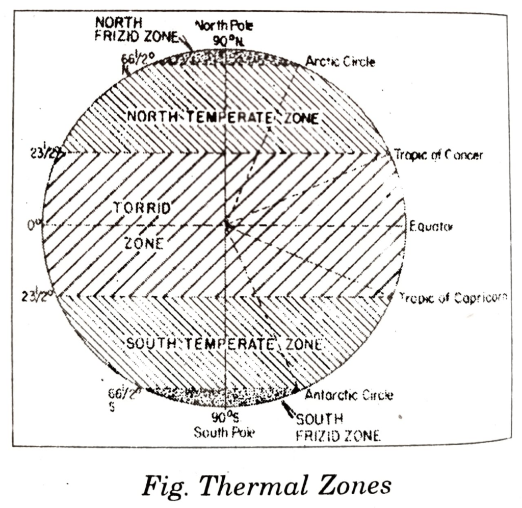
The world is divided into five latitudinal thermal zones. The following are the thermal zones:
A. Torrid Zone:
1. It is largest zone of the thermal zones.
2. It covers almost half of the area of the earth’s surface.
3. It is situated between the Tropic of Cancer and Tropic of Capricorn.
4. The sun’s rays are almost vertical throughout the year in this zone.
5. The mid day sun is overhead at equator on equinoxes i.e. on 21st March and 23rd September.
6. It is also overhead at Tropic of Cancer on 21st june and at at Tropic of Capricorn on 22nd December.
B. Temperate Zone:
1. The temperate zones are on either side of the torrid zone.
2. The North Temperate zone lies between Tropic of Cancer (23 1/2° N) and Artic Circle (661/2°).
3. The South temperate zone lies between Tropic of Capricorn (23 1/2°S) and Antarctic Circle (661/2°S).
4. The sun is never overhead in this zone in winter season. The nights are longer and days are shorter and vice-versa in summer.
5. The difference between the duration of day in summer and that of night in winter in the polar circles in 24 hours.
C. Frigid Zone:
1. Frigid zone is found in both the hemispheres like temperate zone.
2. North Frigid zone lies between Arctic Circle (66 1/2°N) and North Pole (90°N).
3. The South Frigid Zone lies between Antarctic Circle (66 1/2°S) ans South Pole (90°S).
4. During winter season the sun does not rise above the horizon for almost six months.
5. These are coldest regions of the world.
