
NCERT Class 8 Social Science Chapter 14 India’s Urban Landscape Solutions English Medium As Per New Syllabus. to each chapter is provided in the list so that you can easily browse through different chapters NCERT Class 8 Social Science Chapter 14 India’s Urban Landscape Notes and select need one. NCERT Class 8 Social Science Chapter 14 India’s Urban Landscape Question Answers Download PDF. NCERT Class 8 Social Science Texbook Solutions English Medium.
NCERT Class 8 Social Science Chapter 14 India’s Urban Landscape
Also, you can read the NCERT book online in these sections Solutions by Expert Teachers as per Central Board of Secondary Education (CBSE) Book guidelines. CBSE Class 8 Social Science Textual Solutions in English Medium are part of All Subject Solutions. Here we have given NCERT Class 8 Social Science Notes, CBSE Class 8 Social Science English Medium Solutions for All Chapters, You can practice these here.
India’s Urban Landscape
Chapter: 14
| Theme E — Economic Life Around Us |
The Big Questions
1. How do cities become the centre of diverse economic activities?
Ans: Cities become centres of economic activities because of trade, industries, transport facilities, businesses, tourism and employment opportunities.
2. In what ways can urbanisation impact people’s lives?
Ans: Urbanisation provides better jobs, education, healthcare and transport facilities. However, it can also cause pollution, overcrowding and traffic jams.
3. What kind of challenges do cities face in the 21st century?
Ans: Cities face challenges such as pollution, traffic jams, water shortage, overcrowding, slums, waste generation and lack of green spaces.
4. How can effective urban planning improve life in cities?
Ans: Effective urban planning provides better roads, housing, transport, schools, hospitals, parks, clean water and proper waste management. It makes cities cleaner, safer and more comfortable.
LET’S EXPLORE
1. Where do you live? Is it a village, town or city? In what ways can you differentiate between urban and rural areas? Write your observations and share with your classmates. (Page 192)
Ans: I live in a town. Urban and rural areas can be differentiated in the following ways:
(i) Population: Urban areas have more people, while rural areas have fewer people.
(ii) Occupation: Urban people mainly work in offices, businesses and industries, while rural people mostly depend on agriculture.
(iii) Facilities: Urban areas have better schools, hospitals, roads and transport facilities.
(iv) Environment: Urban areas have more buildings and traffic, while rural areas have more greenery and open spaces.
(v) Lifestyle: Urban life is generally busy, whereas rural life is comparatively simple and peaceful.
2. Observe and compare the two satellite images of an area of Bengaluru (Fig. 7.5). They are from 2012 and 2025, respectively. What are your observations? What has changed? Guess what might be the causes for the change. (Page 194)
Ans: By comparing the satellite images of Bengaluru from 2012 and 2025, I observe the following changes:
(i) The number of buildings and residential areas has increased.
(ii) Open spaces and green areas have decreased.
(iii) Roads and transport facilities have expanded.
(iv) The area has become more crowded and developed.
Causes: These changes may be due to population growth, migration, industrialisation, construction and rapid urban development.
3. Can you name some towns and cities near you? Find out some interesting traditions, cuisines, and customs specific to those areas, and discuss them in class. (Page 104)
Ans: Some important towns and cities near my area are Guwahati, North Guwahati, Rangia, Nalbari and Hajo. They are known for their unique traditions, cuisines and customs.
(i) Guwahati: Famous for Bihu, Ambubachi Mela, Masor Tenga and Pitha.
(ii) North Guwahati: Known for ancient temples, religious traditions and Doul Utsav.
(iii) Rangia: Known for Bihu celebrations, traditional Assamese food and agricultural culture.
(iv) Nalbari: Famous for Ras Mahotsav, Pitha and traditional Assamese culture.
(v) Hajo: Known for its religious harmony, historical temples and Powa Mecca.
THINK ABOUT IT
1. Fig. 7.3 shows the satellite view of a village and a city in Haryana, respectively. The larger blocks of green and brown land on the left in the village show open areas, whereas the grey built-up area on the right shows a complex network of buildings. What can you infer about the population density of the two regions? Why do you think such a difference exists? (PAge 193)
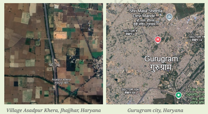
Ans: (i) The village of Asadpur Khera has a low population density, as it has large open spaces, agricultural fields and fewer buildings.
(ii) Gurugram city has a high population density, as it has many buildings, houses, roads and other facilities.
(iii) This difference exists because more people move to cities for better job opportunities, education, healthcare and other facilities.
2. Observe the pictures in Fig. 7.18. Do you notice the other side of the city? What could be the possible challenges faced by people living in urban slums? (Page 203)
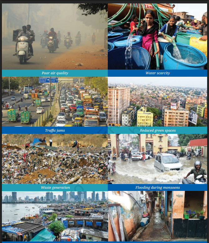
Ans: The pictures show the problems faced by people living in urban slums:
(i) Poor housing and overcrowded living conditions.
(ii) Lack of clean drinking water and proper sanitation.
(iii) Air pollution and unhygienic surroundings.
(iv) Poor waste management and drainage facilities.
(v) Flooding during the monsoon season.
(vi) Limited access to basic facilities like healthcare and education.
Questions and activities
1. What are some common features of cities?
Ans: Some common features of cities are:
(i) High population and crowded residential areas.
(ii) Well-developed roads, transport and communication facilities.
(iii) Schools, colleges, hospitals, markets and shopping centres.
(iv) Different job opportunities in industries, offices and businesses.
(v) Government offices, parks and other public facilities.
2. Can you think of a city or town near you that has grown in population? What could be the underlying reasons for the urban migration?
Ans: Guwahati is a city near my area that has grown rapidly in population. The main reasons for urban migration are:
(i) Better job and business opportunities.
(ii) Availability of good schools and colleges.
(iii) Better healthcare and transport facilities.
(iv) Development of industries, offices and markets.
(v) Better living opportunities attract people from rural areas.
3. With reference to the epigraph at the beginning of the chapter, who are the participants in the making of the city and what could be their contribution?
Ans: The participants in making a city include:
(i) Government: Provides roads, water supply and public facilities.
(ii) Architects and Engineers: Design and construct buildings, roads and bridges.
(iii) Business Owners: Create jobs and support economic growth.
(iv) Workers: Help in construction, industries and daily services.
(v) Citizens: Keep the city clean, follow rules and help in community development.
4. In what ways can urbanisation affect rural areas? Do cities also depend on rural areas? If yes, how? In what ways can rural and urban areas help each other develop?
Ans: Urbanisation affects rural areas in the following ways:
(i) Many people migrate from villages to cities for jobs and better facilities.
(ii) Agricultural land may be used for buildings and industries.
(iii) Rural areas supply food, raw materials and labour to cities.
(iv) Cities depend on villages for vegetables, fruits, milk and other agricultural products.
(v) Cities provide markets, technology, education and healthcare facilities to rural areas.
(vi) Both rural and urban areas can develop through better transport, trade and cooperation.
5. What is urban planning? What are the risks of ignoring sustainable urban planning as cities expand into villages and forest areas?
Ans: Urban planning is the process of designing and organising cities to provide better facilities and a good quality of life.
Ignoring sustainable urban planning can cause several problems:
(i) Loss of forests and agricultural land.
(ii) Displacement of villagers and loss of their homes, livelihoods and traditional ways of life.
(iii) Water shortages and pollution due to excessive use of natural resources.
(iv) Air and water pollution and increasing waste.
(v) Traffic congestion and overcrowding because of unplanned growth.
(vi) Flooding and soil erosion when natural areas are replaced by buildings and roads.
(vii) Increase in temperature and loss of wildlife habitats.
6. Observe your own neighbourhood. What signs of good or poor planning do you notice? How do they affect daily life for you and others?
Ans: In my neighbourhood, I notice both good and poor planning.
(i) Good roads, streetlights, nearby schools, shops and parks make daily life easier and safer.
(ii) Public transport and proper drainage in some areas make travelling convenient.
(iii) Narrow roads, traffic jams and improper parking create difficulties for commuters.
(iv) Blocked drains and overflowing garbage cause waterlogging and unhygienic surroundings.
(v) Fewer green spaces and increasing construction lead to pollution and reduce open areas.
(vi) Good planning improves safety and comfort, while poor planning causes inconvenience and affects people’s health and quality of life.
7. Imagine you are an urban planner, what are the things you would consider to plan a city? Do groups like children, the elderly, and people with disabilities get easy access to parks, toilets, and public transport? What changes would you introduce to make it more inclusive?
Ans: If I were an urban planner, I would consider the following things to make the city well-planned and inclusive:
(i) Proper roads, housing and public transport facilities.
(ii) Adequate water supply, drainage and waste management.
(iii) Schools, hospitals, markets, parks and playgrounds.
(iv) Safe footpaths, ramps and lifts for people with disabilities.
(v) Clean and accessible public toilets for everyone.
(vi) Parks with safe play areas for children and benches for elderly people.
(vii) Low-floor buses and easy access to public transport.
(viii) Proper streetlights, green spaces and safe public areas.
8. Suppose your town, village or city has 100 people. Draw a rough map of the place on a graph paper. Imagine each square on the paper represents a specific area of the place, like residential neighbourhoods, parks, schools, factories, post offices and so on.
Now, distribute the 100 people throughout the area. You can decide where the people will live, whether they all live in the residential areas, or some live in the commercial or industrial areas. Write this number in each of the boxes.
In your depiction of the map, which areas are heavily populated and which are not? What were the reasons behind your choices of allocation of people?
Ans: I imagined my town as a planned city divided into residential, commercial, industrial and public areas.
I distributed the 100 people in the following wing way:
| Area | Number of people |
| Residential area | 70 |
| Commercial area | 10 |
| Industrial area | 8 |
| Schools and public institutions | 5 |
| Transport areas | 3 |
| Parks and open spaces | 2 |
| Government offices and post office | 2 |
| Total | 100 |
(i) Residential areas are the most heavily populated because most people live in houses and apartments.
(ii) Commercial and industrial areas have fewer people because they are mainly used for shops, businesses and factories.
(iii) Parks and open spaces have the fewest people because they are mainly used for recreation.
(iv) I allocated people this way because most people live in residential areas, while other areas are mainly used for work, education and public services.
9. Observe the satellite view of Mumbai and Gangtok, respectively. Find out their population density and likely reasons for the difference.
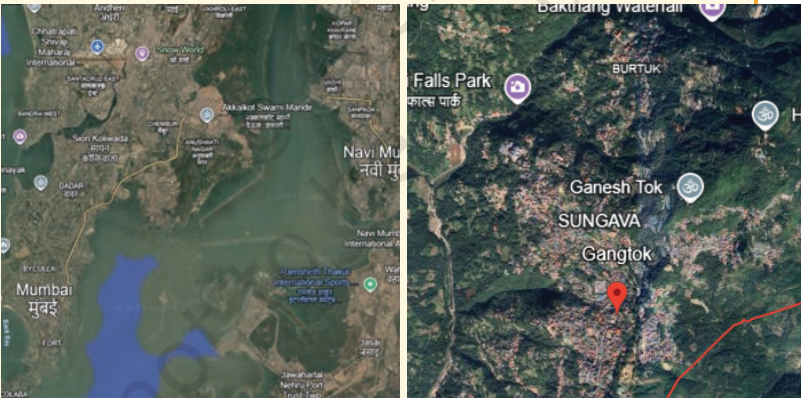
Ans: According to Census 2011 data, the approximate population densities are:
Mumbai: 20,600 people per sq. km. (Greater Mumbai)
Gangtok: 5,200 people per sq. km. (Municipal area)
NITI Aayog+1
The likely reasons for the difference are:
(i) Mumbai has more industries, businesses, offices and job opportunities, which attract people
from different parts of India.
(ii) Mumbai is a major commercial and financial centre, leading to a large population.
(iii) Gangtok is a hilly city with steep slopes and limited flat land for construction.
(iv) The difficult mountain terrain restricts the expansion of residential areas in Gangtok.
(v) Therefore, Mumbai has a much higher population density than Gangtok.
10. Find out how Beijing, China, tackled air pollution. Prepare a report outlining measures that can be taken in India to reduce air pollution in cities.
Ans: Report on Air Pollution
Beijing took several steps to control air pollution, such as reducing coal use, controlling vehicle emissions, promoting public transport and shifting industries away from highly polluting fuels.
The following measures can be taken in Indian cities:
(i) Promote electric vehicles and public transport.
(ii) Control smoke and harmful gases from factories.
(iii) Stop the burning of garbage and crop waste.
(iv) Encourage solar energy and other clean fuels.
(v) Plant more trees and develop green spaces.
(vi) Regularly check vehicle emissions and enforce pollution-control rules.
These measures can help make cities cleaner and healthier.
11. Talk to a family or community member who has moved from a village to a city. Ask the reason and their experience, challenges and opportunities. How does city life compare to rural life?
Ans: I spoke to a person who moved from a village to a city. They shared the following experiences:
(i) They moved to the city in search of better job opportunities and education.
(ii) They found better hospitals, schools, transport and other facilities.
(iii) They faced challenges such as high living costs, traffic jams and pollution.
(iv) They also experienced a busy lifestyle and less open space compared to village life.
(v) Village life is more peaceful and connected to nature, while city life offers more employment and modern facilities.
12. Learn about urban planning in other cities around the world. In what ways can some of those aspects be adapted for a city near you?
Ans: Cities like Singapore and Copenhagen are known for planned development and better public facilities.
(i) Develop more parks and green spaces like Singapore.
(ii) Improve public transport and cycling facilities like Copenhagen.
(iii) Provide proper footpaths and safe pedestrian crossings.
(iv) Improve waste management and recycling systems.
(v) Promote rainwater harvesting and sustainable buildings.
13. Suggest action points for urban planning to reduce the following challenges.
Ans: (i) Inadequate safety of residents: Install streetlights, CCTV cameras, emergency helplines and regular police patrols.
(ii) Poor mobility within the city: Improve public transport, construct proper footpaths, develop cycling tracks and provide accessible buses.
(iii) Expansion of slums: Provide affordable housing, basic facilities, clean water and proper sanitation to low-income families.
(iv) Heat waves during summers: Plant more trees, develop green spaces, create shaded public areas and promote cool roofs.
14. Find out about a slum rehabilitation programme where people moved from slums to proper housing in your city. What do you think its possible benefits could be for the communities there?
Ans: The Slum Rehabilitation Authority (SRA) project in Mumbai was started by the Maharashtra Government to provide permanent houses to eligible slum dwellers.
Possible Benefits:
(i) Better Living Conditions: Families get safe and permanent houses.
(ii) Better Health: Clean water, toilets and proper drainage reduce diseases.
(iii) Safety: Strong buildings protect people from floods, fires and bad weather.
(iv) Better Facilities: People get improved access to schools, hospitals and transport.
(v) Dignity: Proper housing improves people’s self-respect and social status.
(vi) Environmental Improvement: Slum rehabilitation can reduce pollution and improve city planning.
Subject Ka Complete Video Solution Dekhein
Step-by-step easy concept explanation aur full questions Answer ke liye watch karein ya app download karein:


 Buy Now