
NCERT Class 8 Social Science Chapter 8 World Geography: Some Glimpses Solutions English Medium As Per New Syllabus. to each chapter is provided in the list so that you can easily browse through different chapters NCERT Class 8 Social Science Chapter 8 World Geography: Some Glimpses Notes and select need one. NCERT Class 8 Social Science Chapter 8 World Geography: Some Glimpses Question Answers Download PDF. NCERT Class 8 Social Science Texbook Solutions English Medium.
NCERT Class 8 Social Science Chapter 8 World Geography: Some Glimpses
Also, you can read the NCERT book online in these sections Solutions by Expert Teachers as per Central Board of Secondary Education (CBSE) Book guidelines. CBSE Class 8 Social Science Textual Solutions in English Medium are part of All Subject Solutions. Here we have given NCERT Class 8 Social Science Notes, CBSE Class 8 Social Science English Medium Solutions for All Chapters, You can practice these here.
World Geography: Some Glimpses
Chapter: 8
| Theme A — India and the World: Land and the People |
The Big Questions
1. What are the unique physical features of the continents?
Ans: Each continent has distinct physical features such as mountains, plateaus, plains, deserts, rivers, oceans and forests. For example, Asia has the Tibetan Plateau and the Gobi Desert; Europe has the European Plain and the Alps; Africa has the Sahara Desert and the River Nile; North America has the Rocky Mountains and the Great Lakes; South America has the Andes Mountains and the Amazon River; Australia has the Great Australian Desert and the Great Barrier Reef; and Antarctica is covered almost entirely with thick ice and glaciers.
2. Why do we need to understand world geography?
Ans: We need to understand world geography to learn how landforms and water bodies influence climate, natural resources, agriculture, trade, and human settlements. Geography explains how mountains, rivers, plains, and oceans shape human life and connect different regions of the world. It also helps us understand the relationship between nature and people.
3. How do human actions trigger environmental issues?
Ans: Human activities such as pollution, overfishing, deforestation, and the excessive use of natural resources disturb the balance of natural ecosystems. Deforestation threatens forests like the Amazon, while pollution and climate change damage coral reefs and other habitats. Global warming also causes the melting of glaciers and permafrost. These activities lead to biodiversity loss, disturb the climate balance, and create serious environmental problems.
LET’S EXPLORE
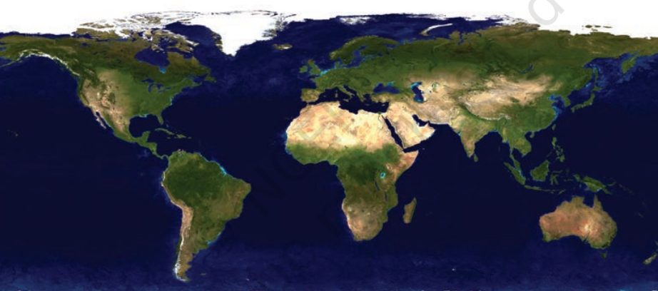
1. What do you think each of the different colours in the map in Fig. 1.1 represents? (Page 2)
Since this chapter is about world geography, we are concerned with physical maps. Physical maps have their own language that use colours —
Blue: water bodies (oceans, seas, lakes, rivers);
Green: plains; Yellow/Brown: plateaus;
Dark brown: high mountains; Light yellow: deserts; White: ice and glacier
Ans: The different colours in the physical map represent various physical features of the Earth:
(i) Blue: Water bodies such as oceans, seas, lakes, and rivers.
(ii) Green: Plains.
(iii) Yellow/Brown: Plateaus.
(iv) Dark Brown: High mountains.
(v) Light Yellow: Deserts.
(vi) White: Ice and glaciers.
2. Study the map in Fig.1.11. What are the different physical features represented here? (Hint: You may refer to LET’S EXPLORE on page 2 of this chapter.) (Page 11)
Ans: The map of Asia represents the following physical features:
(i) Ural Mountains – Mountains.
(ii) Eurasian Steppes – Grasslands.
(iii) Siberian Taiga – Forests.
(iv)Gobi Desert – Desert.
(v) Tibetan Plateau – Plateau.
(vi) Pacific Ocean – Ocean or water body.
3. Assess and describe the Himalayas from the perspective of these different roles. (Page 15)
Ans: The Himalayas play several important roles:
(i) Climate: They act as a barrier to cold winds from Central Asia and influence monsoon rainfall in India.
(ii) Water Towers: Their snow and glaciers provide freshwater to major rivers such as the Ganga, Indus, and Brahmaputra.
(iii) Biodiversity Hotspots: They support a wide variety of plants, animals, and forests.
(iv) Natural Boundary: They form a natural geographical boundary between the Indian subcontinent and the Tibetan Plateau.
4. Observe the area covered by the European Plain. Now turn to the political map of the world at the end of this textbook. List the countries that are part of the European Plain (you need not memorise them). (Page 18)
Ans: The European Plain, also known as the Great European Plain, covers parts of several European countries. These include France, Belgium, the Netherlands, Germany, Poland, Belarus, Ukraine, and parts of western Russia, among others. It extends from western Europe towards the Ural Mountains.
The European Plain is characterised by low-lying land, gentle hills, and wide river valleys. Its fertile soil and favourable conditions support agriculture, dense populations, and the growth of major cities.
5. On the map (Fig. 1.22) locate the course of the River Nile. Where does it originate from and in which direction does it flow? Turn to the political map at the end of the book, and identify some of the areas that the river flows through. (Page 22)
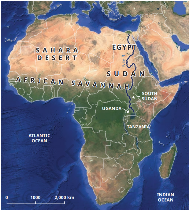
Ans: The River Nile originates in East Africa and flows towards the north. On its way, it passes through Uganda, South Sudan, Sudan, and Egypt before reaching the Mediterranean Sea.
The river provides water for farming and supports human settlements, particularly in the dry regions of Egypt and Sudan. It is an important source of life and livelihood for the people living along its banks.
6. The Amazon Rainforest has been called the ‘Lungs of the Earth’. Why do you think this might be so?
Ans: The Amazon Rainforest is called the ‘Lungs of the Earth’ because its vast forests absorb carbon dioxide and release oxygen through photosynthesis. It also helps regulate the global climate and supports rich biodiversity and many indigenous communities. Therefore, it plays an important role in maintaining the balance of nature and sustaining life on Earth.
7.The countries in this region need land for development but risk losing the Amazon Rainforest. Discuss in groups: What are the short and long-term effects of deforestation, and how can we protect the Amazon for the planet?
Ans: Short-term effects of deforestation:
(i) It provides land for agriculture, industries, roads, and other development activities.
(ii) It destroys the natural habitats of many plants and animals.
(iii) It affects indigenous communities that depend on forests for their livelihood.
Long-term effects of deforestation:
(i) It leads to biodiversity loss and the extinction of many species.
(ii) It contributes to global warming and climate change.
(iii) It disturbs the natural balance of the ecosystem.
Ways to protect the Amazon Rainforest:
(i) Stop illegal cutting of trees and uncontrolled deforestation.
(ii) Promote afforestation and reforestation.
(iii) Use forest resources responsibly and sustainably.
(iv) Protect wildlife and the rights of indigenous communities.
(v) Encourage sustainable development without destroying forests.
THINK ABOUT IT
1. Oceans give us almost half the oxygen we breathe. Tiny marine organisms, such as plankton, make this possible. What do you think would happen to all living beings if pollution harmed these planktons, and they could no longer produce enough oxygen? (Page 4)
Ans: If pollution harmed planktons and they could no longer produce enough oxygen, the oxygen supply in the atmosphere would decrease. This would make it difficult for humans and other living beings to breathe and survive. Marine ecosystems would also be disturbed, affecting the food chain and threatening the survival of many aquatic animals. Thus, pollution harming planktons could create a serious threat to life on Earth.
Questions and activities
1. Why do all map projections have some amount of distortion?
Ans: All map projections have some distortion because the Earth is round, and its curved surface cannot be shown exactly on a flat map. While making maps, it is difficult to maintain the correct shape, size, distance, and direction at the same time. Therefore, some distortion is always present in map projections.
2. What makes the Tibetan Plateau unique?
Ans: The Tibetan Plateau is unique because it is the highest and largest plateau in the world. It is known as the ‘Roof of the World’ because of its great height. It is surrounded by high mountain ranges, including the Himalayas, and is an important source of several major rivers.
3. Why are coral reefs called the ‘rainforests of the sea’?
Ans: Coral reefs are called the ‘rainforests of the sea’ because they support a wide variety of marine plants and animals. They provide food and shelter to many sea creatures and are among the richest ecosystems in the ocean.
4. How do the oceans help to regulate the Earth’s climate?
Ans: Oceans help regulate the Earth’s climate by absorbing and storing heat from the Sun. Ocean currents distribute this heat from one region to another, keeping temperatures balanced. They also influence rainfall and weather patterns around the world.
5. What is the main reason for the Great Barrier Reef facing threats today?
Ans: The Great Barrier Reef is mainly threatened by climate change, especially rising ocean temperatures. This causes coral bleaching, which damages corals and threatens the marine life that depends on them. Pollution and human activities also contribute to its decline.
6. Why is the Amazon Rainforest often called the ‘Lungs of the Earth’?
Ans: The Amazon Rainforest is called the ‘Lungs of the Earth’ because its vast forests absorb carbon dioxide and release oxygen through photosynthesis. It also helps regulate the global climate and supports a rich variety of plants and animals.
7. Choose two different types of geographical features you have explored in this chapter. Write short paragraphs on how they influence the flora and fauna or human lives in that area. Do they also have an implication for the whole globe?
Ans: (i) The Himalayas: The Himalayas influence the climate and support a wide variety of plants and animals. They act as a barrier to cold winds and help bring rainfall through the monsoon. Their glaciers are also the source of major rivers such as the Ganga, Indus and Brahmaputra, which provide water for millions of people. They play an important role in maintaining the climate and water supply of the region.
(ii) The Amazon Rainforest: The Amazon Rainforest is home to a rich variety of plants, animals and indigenous communities. It provides food, shelter and livelihood to many living beings. Its trees absorb carbon dioxide and release oxygen, helping to maintain the balance of gases in the atmosphere. It also influences the global climate and plays an important role in protecting biodiversity.
8. Discuss how oceans influence climate and trade. Use examples from the Indian and Pacific Oceans.
Ans: Oceans play an important role in regulating climate and supporting international trade.
(i) Climate: The Indian and Pacific Oceans absorb and distribute heat, influence monsoon winds and rainfall, and help regulate temperatures in nearby regions.
(ii) Trade: These oceans provide important sea routes for transporting goods between countries. The Indian Ocean connects Asia, Africa and Europe, while the Pacific Ocean connects Asia, Australia and the Americas. They support international trade and economic activities.
9. Choose one environmental issue (deforestation, reef bleaching, or desertification) and explain its causes, impacts, and possible solutions.
Ans: Environmental Issue – Deforestation
(i) Causes: Deforestation occurs due to the clearing of forests for agriculture, industries, roads, settlements and other human activities.
(ii) Impacts: It destroys the natural habitats of wildlife, reduces biodiversity, increases carbon dioxide in the atmosphere and contributes to climate change. It also affects the lives of people who depend on forests.
(iii) Possible Solutions: We should stop unnecessary cutting of trees, promote afforestation and reforestation, protect wildlife habitats and use forest resources sustainably.
10. Imagine you are a geographer asked to advise a government about protecting one major landscape in your country. Which one would you choose, and why?
Ans: I would choose the Himalayan region for protection because it is one of the most important geographical landscapes of India. It is home to diverse plants and animals and is the source of major rivers such as the Ganga, Indus and Brahmaputra. It also influences India’s climate and supports the livelihoods of millions of people. The government should promote afforestation, control pollution, prevent unplanned construction and encourage sustainable tourism to protect this region.
11. Imagine that someone is funding a group of you for a road trip across two continents. There are differences of opinion on which two they should be. Make a pitch for the ones you would like everyone to go to. Use a blank map, trace your route and locate the places on it, and try to convince the others to your point of view. You could use a variety of creative ways.
Ans: I would suggest choosing Asia and Europe for our road trip because these two continents offer a wonderful combination of natural beauty, history, culture and modern development.
Our journey would begin in Istanbul, Turkey, which connects Europe and Asia. From there, we would travel to Ankara, Cappadocia and Antalya.
(i) Istanbul: We can explore historical monuments and experience the meeting of European and Asian cultures.
(ii) Ankara: We can learn about Turkey’s history and modern development.
(iii) Cappadocia: We can enjoy its unique rock formations and beautiful landscapes.
(iv) Antalya: We can explore its beautiful beaches and coastal scenery.
This journey would help us understand the geographical and cultural diversity of two continents. It would be an exciting educational experience and a memorable adventure.
Map activity: On a blank map, mark and connect these places in order:
Istanbul → Ankara → Cappadocia → Antalya.
Subject Ka Complete Video Solution Dekhein
Step-by-step easy concept explanation aur full questions Answer ke liye watch karein ya app download karein:

 Buy Now