NCERT Class 6 Social Science Chapter 1 Locating Places on the Earth Solutions English Medium As Per CBSE New Syllabus to each chapter is provided in the list so that you can easily browse through different chapters NCERT Class 6 Social Science Chapter 1 Locating Places on the Earth Question Answer and select need one. NCERT Class 6 Social Science Chapter 1 Locating Places on the Earth Notes Download PDF. CBSE Class 6 Solutions for Social Science in English.
NCERT Class 6 Social Science Chapter 1 Locating Places on the Earth


Also, you can read the NCERT book online in these sections Solutions by Expert Teachers as per Central Board of Secondary Education (CBSE) Book guidelines. NCERT Class 6 Social Science Chapter 1 Locating Places on the Earth Textual Solutions are part of All Subject Solutions. Here we have given CBSE Class 6 Social Science Textbook Solutions English Medium for All Chapters, You can practice these here.
Locating Places on the Earth
Chapter: 1
| TEXTUAL QUESTION ANSWER |
| Theme A: India and the World: Land and the People |
The Big Questions
1. What is a map and how do we use it? What are its main components?
Ans: A map is a symbolic representation or sketch of the Earth’s surface, or a part of it, drawn on a flat surface using a scale. It shows the surface as if viewed from above and can represent a small area like a village, a large region such as a state, or even the entire world. Maps are used to identify the position of a location and to find the way to reach there. They also show directions, usually with arrows or a compass, which help us in navigation and better understanding of places.
The main components of a map are the title, which explains what the map is about; the scale, which shows the ratio between distance on the map and the actual distance on the ground; directions, usually shown with arrows or a compass rose; symbols or legend, which describe the meaning of different signs and colors; and the grid or coordinates, which help in accurately locating any place. These components together make the map clear and easy to use.
2. What are coordinates? How can latitude and longitude be used to mark any location on the Earth?
Ans: A coordinate or index is a relative measure of the change in a fact such as price, quantity, production, etc. in two time periods or two places. They use geographic coordinate systems measured in fractions of latitude and longitude to precisely locate any location on Earth. This system creates a grid over the entire planet.
Lines of latitude run parallel to the equator and lines of longitude run from the north to the south pole.By using both latitude and longitude together, we can mark the precise location of any place on the Earth. For example, the coordinates 28° N latitude and 77° E longitude indicate the location of New Delhi. Thus, latitude and longitude act like a grid system that helps in accurately identifying and locating places on maps and globes.
3. How are local time and standard time related to longitude?
Ans: Local time is directly determined by a location’s longitude and the position of the sun, changing by four minutes for every degree of longitude. Standard time is a uniform time for a larger region or country, based on the local time of a central meridian (often a line of longitude), to avoid the confusion of varying local times. which is usually a multiple of 15 degrees (1 hour) at a specific longitude. Each 15 degrees of longitude represents a difference of 1 hour from Coordinated Universal Time (UTC).
| Questions, activities and projects |
1. Returning to page 10 and to Fig. 5.2 in Chapter 5 of this textbook, taking the scale to be 2.5 cm = 500 km, calculate the real distance from the estuary of the Narmada River to the estuary of the Ganga river. (Hint: round off your measurement on the map to an easy number.)
Ans: Do it yourself.
2. Why is it 5:30 pm in India when it is 12 pm or noon in London?
Ans: India time is 5 hours 30 minutes ahead of London time. So when it is 12:00 noon in London, it is 5:30 pm in India.
3. Why do we need symbols and colours in the map?
Ans: We need symbols and colours in a map because it is not possible to draw the actual size and shape of various features like buildings, roads, bridges, trees, railway lines on a map. So, they are shown using some letters, colours, pictures and lines. For example, blue is used for water, green for plains, brown for mountains, and red for important roads. These symbols and colours are explained in the legend or key of the map. Thus, they help in making the map clear, easy to read, and universally understood.
4. Find out what you have in the eight directions from your home or school.
Ans: Do yourself.
5. What is the difference between local time and standard time? Discuss it in groups, with each group writing an answer in 100 to 150 words. Compare the answers.
Ans: Local time refers to the time based on the position of the sun at a specific location, which can vary significantly from one place to another. It is determined by the rotation of the Earth, where each location experiences sunrise, sunset, and the highest point of the sun (solar noon) at different times. This leads to variations in local time depending on the longitude and latitude of a place. while standard time is based on time zones. Uniformity: Local time changes every 15 degrees of longitude, while standard time remains the same throughout a given time zone.In contrast, standard time is the uniform time adopted for an entire country or a large region. This time is set according to the local time of a central meridian and helps maintain consistency for activities like travel, business, and communication. Standard time zones ensure that within a specific zone, the clock time is the same, preventing confusion from constantly changing local times.
6. Delhi’s and Bengaluru’s latitudes are 29°N and 13°N; their longitudes are almost the same, 77°E. How much will be the difference in local time between the two cities?
Ans: There will be no significant difference in the local time between Delhi and Bengaluru because their longitudes are almost the same (77°E). Therefore, there will be no difference in time based only on latitude, because without difference in longitude, there is no difference in time.
7. Mark the following statements as true or false; explain your answers with a sentence or two.
(i) All parallels of latitude have the same length.
Ans: The statement is false because the length of the parallels of latitude is maximum at the equator and gradually decreases as we move towards the poles.
(ii) The length of a meridian of longitude is half of that of the Equator.
Ans: This statement is False. Because the length of the meridian of longitude is greatest at the equator and decreases towards the poles.
(iii) The South Pole has a latitude of 90°S.
Ans: This statement is True. Because the latitude of the South Pole is 90°and South (90° S).
(iv) In Assam, the local time and the IST are identical.
Ans: This statement is True. Because the local time and Indian Standard Time (IST) are the same in Assam.
(v) Lines separating the time zones are identical with meridians of longitude.
Ans: This statement is True. Because Time zone lines are similar to longitude meridians.
(vi) The Equator is also a parallel of latitude.
Ans: This statement is True. Because the equator is the 0° latitude circle.
8. Solve the crossword below.
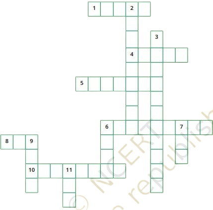
Across:
1. Lets you squeeze a huge area into your map
4. A convenient sphere
5. The longest parallel of latitude
6. The place the Prime Meridian is attached to
8. So convenient to find your way
10. A measure of the distance from the Equator
Down:
2. A measure of the distance from the Prime Meridian
3. These two together allow us to locate a place
6. What latitudes and longitudes together create
7. The time we all follow in India
9. On top of the world
11. An abbreviation for a line across which the day and date change
Ans: Across:
1. Scale.
4. Globe.
5. Equator.
6. Greenwich.
8. Compass.
10. Latitude.
Down:
2. Longitude.
3. Coordinates Grid.
7. IST North Pole.
11. IDL.

Hi! my Name is Parimal Roy. I have completed my Bachelor’s degree in Philosophy (B.A.) from Silapathar General College. Currently, I am working as an HR Manager at Dev Library. It is a website that provides study materials for students from Class 3 to 12, including SCERT and NCERT notes. It also offers resources for BA, B.Com, B.Sc, and Computer Science, along with postgraduate notes. Besides study materials, the website has novels, eBooks, health and finance articles, biographies, quotes, and more.