NCERT Class 9 Social Science Chapter 26 Specific Hazards And Mitigation Solutions to each chapter is provided in the list so that you can easily browse through different chapters NCERT Class 9 Social Science Chapter 26 Specific Hazards And Mitigation and select need one. NCERT Class 9 Social Science Chapter 26 Specific Hazards And Mitigation Question Answers Download PDF. NCERT SST Class 9 Solutions.
NCERT Class 9 Social Science Chapter 26 Specific Hazards And Mitigation


Also, you can read the NCERT book online in these sections Solutions by Expert Teachers as per Central Board of Secondary Education (CBSE) Book guidelines. CBSE Class 9 Social Science Solutions are part of All Subject Solutions. Here we have given NCERT Class 9 Social Science Chapter 26 Specific Hazards And Mitigation, NCERT Class 9 Social Science Textbook of India and The Contemporary World – I: History, Contemporary India -I: Geography, Democratic Politics – I: Political Science, Economics and Disaster Management. for All Chapters, You can practice these here.
Specific Hazards And Mitigation
Chapter: 26
DISASTER MANAGEMENT
TOGETHER TOWARDS A SAFER INDIA (PART-II)
NCERT TEXTBOOK QUESTIONS WITH ANSWERS
Q. 1. How do soils affect vulnerability to an earthquake?
Ans. The soils affect vulnerability to an earthquake especially alluvial soil deposit areas pour to landslides.
Q. 2. List down actions that could be taken in your school and home to reduce vulnerability is earthquake damage. Discuss with your teacher and parents.
Ans. 1. Location of settlement.
2. Dense collection of weak buildings with high occupancy.
3. Buildings constructed by earth, rubble, bricks and maintenance of buildings.
4. Weak or flexible story intending for parking purposes.
SOME OTHER IMPORTANT QUESTIONS WITH ANSWERS FOR EXAMINATION
Q. 1. Study the given diagram. Some earthquakes release as much of energy as do 1,00,00 atomic bombs of the type dropped on Nagasaki during the course of the Second World War. Still this is only half the story. In the Alaska earthquake of 1964 mud boils (called liquefaction) were formed beneath some tall buildings. Answer the questions that follow:
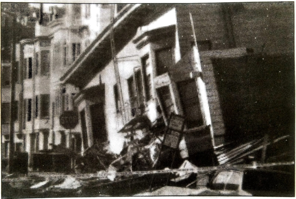
(i) How do we know about earthquakes?
Ans. We know about the earthquakes by sudden shaking of the earth.
(ii) Why did the tall buildings tilt?
Ans. The tall buddings tiled due to an liquefaction beneath the surface.
(iii) State any three effects of liquefaction.
Ans. 1. Tilt of buildings.
2. Mud volcanoes.
3. Mud eruption.
Q. 2. (i) Name any five sudden onset hazards.
Ans. 1. Earthquakes.
2. Volcano.
3. Landslides.
4. Tsunamis.
5. Cloud burst.
(ii) What is called lag-time of a hazard? What are the advantages of building a lag time sequence during or after a hazard?
Ans. Lag time is a period of time between two similar or different hazards. It so happens that a major earthquake shock is followed by shocks of lesser intensity. The advantage of building a lag time sequence the experts are also able to calculate the probability of further or future happenings or events.
(iii) State the general characteristics of an earthquake.
Ans. General characteristics of an earthquake:
1. Shaking or vibrating of earth.
2. Trembling of buildings, trees, poles etc.
3. Panic among people and animals.
4. Collapse of building depends on intensity of quake.
(iv) Name highly vulnerable earthquake zones in India.
Ans. These are:
1. North-Eastern part of India.
2. Western part of Gujarat.
3. Some northern part (including Himachal Pradesh) of India.
4. Some part of Maharashtra.
(v) In addition to earthquakes what other dangers are associated with earthquakes and fault lines?
Ans. Landslides, Tsunamis etc.
(vi) What are the typical effects of an earthquake?
Ans. 1. Physical damages- includes collapse of buildings, cracks in ground, road, bridges, wall, water tank and dams.
2. Panic- Vibratory waves of earthquake cause panic among animals and humans.
3. Public health- Hazards of disease on account of pollution of water bodies, break down of sewage and sanitary pipes.
4. Disruption of economic activities- Economic activities of the people like farming, trades and services are severely affected.
5. Fire- Collapse of container containing gas, petrol, kerosene etc. pose the danger to fire. Several times major fire are caused by earthquakes.
6. Civic services and conveyances: Civic services like water pipes, sewers, electric connections, road etc. are disrupted.
(vii) What factors are considered in the hazard assessment of an earthquake?
Ans. Some of the important factors are considered in hazard assessment are the following:
1. Systematic evaluation of various mitigation strategies available for deployment in the field.
2. Development of coordinated approach for the whole affected areas.
3. Full range of technologies available and creation of computerized data base.
4. Inventory of mitigation measures and introduction of new technology.
5. Magnitude assessment of earthquakes.
(viii) Mention do’s and don’ts before, during and after an earthquake.
Ans.
| Before | During | After |
| 1. Evacuation to begin soon after warnings announced. | 1. Don’t panic. | 1. Closely watch your family member specially elders and children. |
| 2. If not evacuated. store supplies including water. | 2. Stay where you are, but avoid walls, doors etc. | 2. Keep gas closed. |
| 3. Take advice from experts to avoid risk and danger. | 3. Keep close watch for cracks, plaster etc. | 3. Do not turn off your radio, T.V. listen to emergency announcement. |
| 4. Remove dangerous overhangs. | 4. If you are in a moving car, move over to a side, never cross a bridge and tunnels. | 4. Stay away from damaged structure. |
| 5. Provide support to weak walls. | 5. Be prepared for middle or secondary shock. | |
| 6. Move out of building into open but not near walls. |
Q. 3. Fill in the blanks:
(i) Three factors associated with risk management are _________.
Ans. onset type, warning, vulnerability.
(ii) The impact of disasters depends on _________ and __________.
Ans. community preparedness, impact reduction strategies.
(iii) The physical damage caused by earthquakes include _________ and ___________.
Ans. landslide and floods.
(iv) Earthquake is a ________ onset hazard.
Ans. sudden.
LANDSLIDES
POINTS TO REMEMBER
| 1. Landslides: It is slippery masses of rock, earth or debris which move by force of their own weight down mountain slopes or river banks. 2. Liquefaction: A process of formation of mud boils. 3. Main mitigation strategies: Hazard mapping, land use, retaining walls, surface drainage control works, engineered structures, increasing vegetation cover etc. |
VIVA VOCE
Q. 1. What is landslides?
Ans. Landslides are slippery masses of rock, earth or debris which move by force of their own weight down mountain slopes or river banks.
Q. 2. What are the elements at risk of landslides?
Ans. Buildings built on steep slopes.
Roads and communication lines are also vulnerable.
Q. 3. Explain typical effects of landslides.
Ans. 1. Physical damage-
(i) Landslides destroy anything that comes in their path.
(ii) They block roads, line of communication, settlements, river flow etc.
2. Casualties- It caused large number of deaths depending on the time of occurrence.
Q. 4. What is the main mitigation strategies?
Ans. 1. Hazard mapping: It will locate areas prone to landslide. So that areas can be avoided for building settlements.
2. Land use: Forests should be preserved. Reafforestation on denuded upper slopes.
3. Retaining walls: can be built to stop land from slipping.
4. Surface drainage control works: It is implemented to control the movement of landslides.
5. Engineered structures: with strong foundation can withstand or take the ground movement forces.
6. Increasing vegetation cover: is the cheapest and most effective way of arresting landslides.
Q. 5. Give an account of Badrinath Landslide on July 2004.
Ans. July 2004 a landslide blocked the pilgrimage route to Badrinath in Uttranchal. Massive rescues efforts had to be launched in the hill near Badrinath. In addition 1000 shopkeepers and 2500 villagers were trapped and remained cut off for 3 days.
Cause: 1. Overcrowding of tourists and pilgrims.
2. Drilling and blasting undertaken by an Industrial agency.
Strategies: 1. Deployment of army, Jawans of Indo-Tibetan Border Police.
2. Helicopter were pressed into service to airlift some tourists and pilgrims.
3. The same helicopters dropped food packets for stranded people.
FLOODS
POINTS TO REMEMBER
| 1. Floods: These are temporary inundation of large regions as a result of an increase in reservoir, or of rivers flooding their banks because of heavy rains, high winds, cyclones, storm surge along coast, tsunami, melting snow or dam bursts. 2. Drainage basin: The area drained by the water of a river. 3. Flood Plain: The flattish area alongside river channels covered by water during floods is called flood plain. 4. The Catchment Area: The area in the upper course of the river which catches rainfall and feeds the river. |
VIVA VOCE
Q. 1. How sand bag stacking are built and what makes them more effective?
Ans. The sand bag stacking are built to keep the flood water away. Sand debris make the sand bags more effective if these are piled up in a line.
Q. 2. What are floods?
Ans. Floods are temporary inundation of large regions as a result of an increase in reservoir or of rivers flooding their banks because of heavy rains, high winds, cyclones, storm surge along coast, tsunami, melting snow or dam bursts.
Q. 3. Explain the onset type, warning and elements at risk associated with floods.
Ans. Onset Type: Sudden occur due to heavy rains, breach of water storage.
Warning: Warnings are issued by Central Water Commission, Irrigation and Flood Departments to aware people from the risk.
Elements at Risk: Anything in the flood plains will get submerged. Buildings built of weak foundation and water soluble materials will collapse.
Utilities such as sewerage, water supply, communication lines and power are put at risk. Food stock, agricultural fields, livestock, vehicles etc are at risk.
Q. 4. What are the typical effects of flood hazard?
Ans. 1. Physical damage- structures, boat and fishing equipments etc. are damaged.
2. Casualties and public health- people and livestock deaths are caused by drowning, diarrhea, viral infections etc.
3. Water supplies- contamination of water and scarcity of safe drinking water.
4. Crops and food supply- sudden food shortage due to submergence of agricultural fields.
Q. 5. Explain the main mitigation strategies of floods.
Ans. 1. Mapping of the flood plains.
2. Land-use control: It will reduce the danger of life and property. No major development should be permitted in the areas which are subjected to flooding.
3. Construction of engineered structures: which are can withstand the flood and seepage due to floods.
4. Flood control: It aims to reduce flood damage. This can be done by Flood Reduction which decrease the amount of run off by treatment like reforestation, construction of check dams etc.
5. Flood proofing: also reduces the risk of damages.
Q. 6. Name the areas and states in India which are prone to floods.
Ans. Coastal areas like Orissa, Andhra Pradesh due to cyclones.
Bihar, Assam, West Bengal due to heavy rains.
Q 7. What is known as probability period during a flood? State its advantages.
Ans. Most floods are proceeded by heavy rain and melting snow over several days during this period can be guessed of flooding. This period as known as probability period. During probability period evacuation of people is possible.
Q. 8. What are known as hydrographs?
Ans. The hydrographs are used to show the lag time between heavy rainfall and peak discharge.
Q. 9. How do human actions cause floods?
Ans. Human actions can be seen causing floods:
1. Deforestation: Lack of trees promote to rapid surface flow and does not allow water seepage.
2. Breach of embankments.
3. Pollution related heavy downpour is major cause of floods.
4. Dams impounded river water and raise its level. During rainfall the level reaches the peak point.
Q. 10. Match the two columns:
| ‘A’ | ‘B’ |
| 1. A smaller river joining the main river. | (a) Peneplain. |
| 2. The flattish area alongside river channel covered with water during floods. | (b) Dikes and levees. |
| 3. The low lying areas of floodplains. | (c) Tributary. |
| 4. Artificial embankments. | (d) Viaduct. |
| 5. A low ground to carry flood water. | (e) Floodplain. |
Ans.
| ‘A’ | ‘B’ |
| 1. A smaller river joining the main river. | (c) Tributary. |
| 2. The flattish area alongside river channel covered with water during floods. | (e) Floodplain. |
| 3. The low lying areas of floodplains. | (a) Peneplain. |
| 4. Artificial embankments. | (d) Viaduct. |
| 5. A low ground to carry flood water. | (b) Dikes and levees. |
CYCLONES
POINTS TO REMEMBER
| 1. Cyclone: These are violent storms, often of vast extent, characterized by high winds rotating about a calm center of low atmospheric pressure. This center moved onward, often with a velocity of 50 km/h. 2. Plant shelter belts: Rows of strong rooted trees with needle like leaves are planted in the direction facing the wind. |
VIVA VOCE
Q. 1. Define cyclone.
Ans. High winds rotating about a calm center of low atmospheric pressure is called cyclone. This center moves onward, often with a velocity of 50 km. an hour.
Q. 2. What are the typical effects of cyclones?
Ans. 1. Physical damage- structures will be damaged by the wind force, flooding storm surge and landslides.
2. Casualties caused by flooding and flying elements.
3. Water supplies- ground and piped water supply may get contaminated by flood waters.
4. Crops and food supplies- High speed winds and rain will destroy the crops.
5. Communication- severe disruption in the communication links.
Q. 3. A cyclone is a low pressure area usually formed in a disturbing zone of warm and cold air masses. Study the figure and answer the questions below.
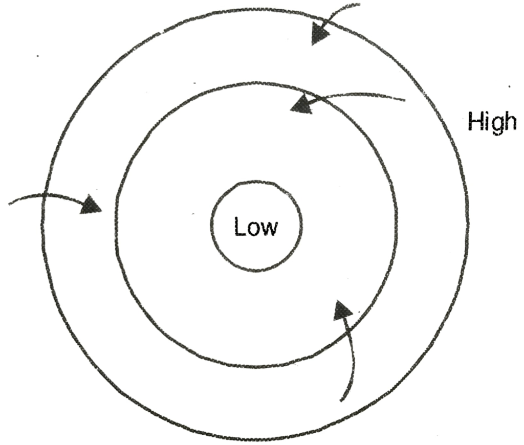
(i) Why does the air move inward?
Ans. The air moves inward due to the low pressure of air.
(ii) Why does heavy downpour occur during the storm?
Ans. The heavy downpour occur during the storm because the storm rises on the sea or ocean and the moisture loaded air comes in the contact of cold air caused heavy rain.
(iii) State the onset type of the cyclone.
Ans. The cyclone strikes suddenly.
(iv) How does the cyclone put things in its path at risk?
Ans. People, animals and even birds and other structures coming in the path of cyclone face death and destruction.
(v) Describe the main strategies for overcoming the hazard.
Ans. 1. Hazard mapping – A hazard map will illustrate the area vulnerable to the cyclone in any given year.
2. Land-use control: Avoid location of settlements in the flood plains.
3. Multipurpose cyclone shelters of designs have been constructed in vulnerable locations at coastal areas.
4. Engineered structures – Structures to be built withstand wind forces.
5. Flood management – Flood mitigation measures could be incorporated.
6. Coastal shelter belt plantation programme: Shelter belt along the coast line will mitigate the impact of strong cyclonic winds and thus check soil erosion and inward sand drift.
7. Improving vegetation cover: Improvement of the vegetation will increase the water infiltration capacity of the soil.
(vi) What type of evaluation is carried out in the case of a cyclone?
Ans. Evaluation is done in respect of avoidance of the hazard them making everything cyclone proof in its path.
Q. 4. Match the two columns:
| ‘A’ | ‘B’ |
| 1. Meteorological Department | (a) 1999 |
| 2. Orissa Super Cyclone | (b) Winds |
| 3. Barometer | (c) Coconut trees |
| 4. Plant shelter belts | (d) Cyclone tracking |
| 5. Most vulnerable to cyclone | (e) Pressure |
Ans.
| ‘A’ | ‘B’ |
| 1. Meteorological Department | (a) 1999 |
| 2. Orissa Super Cyclone | (d) Cyclone tracking |
| 3. Barometer | (e) Pressure |
| 4. Plant shelter belts | (c) Coconut trees |
| 5. Most vulnerable to cyclone | (b) Winds |
DROUGHT
POINTS TO REMEMBER
| 1. Drought: It is an insidious natural hazard that results from a departure of precipitation from expected or normal that, when extended over a season or longer period of time, is insufficient to meet the demands of human, plant and animals activities. 2. Watershed: Watershed are geographic area where the water flows to a common point. |
VIVA VOCE
Q. 1. Define drought.
Ans. Drought is a natural hazard that result from lack of precipitation from expected or normal that when extended over a season or longer period of time, is insufficient to meet the demands of human, plant and animals activities.
Q. 2. What is onset type and warning?
Ans. Onset type is slow disaster warning. According to Indian Meteorological Department, the country is said to be drought affected when the over all rainfall deficiency is more than 10% of long period average.
Q. 3. What is the elements at risk?
Ans. Elements at risk are:
1. Rainfed crops.
2. Areas with minimum of alternative water sources to rainfall i.e. ground and canal water supplies.
3. Areas of deforestation.
4. Areas where livelihood is earned by agriculture.
5. Landless labourers, subsistence farmers. farm animals are the most vulnerable groups affected by drought.
Q. 4. Describe the main mitigation to overcome drought effects.
Ans. 1. Drought monitoring: Observation of rainfall situation, water availability in reservoirs, lakes comparing with existing water needs of Various sectors of the society.
2. Water supplier augmentation and conservation through rainwater harvesting in houses and fields.
Q. 5. What are the typical effects of the Drought?
Ans. 1. Failure of crops.
2. Soil erosion.
3. Famine conditions.
4. Acute drinking water crisis.
5. Reduced energy production.
6. Wide spread unemployment.
7. High and rising prices.
8. Health problems.
9. Starvation cause deaths.
Q. 6. Fill in the blanks:
1. Slow moving drought conditions themselves serve as _________.
Ans. hazard.
2. Most _________ section and poverty stricken people.
Ans. affected.
3. A typical effect of a drought is crops _________ of crops.
Ans. failure.
4. __________ conditions prevail during drought.
Ans. Famine.
5. _________ can be done before, during and after a drought.
Ans. Livelihood planning.
Q. 7. Mention the drought prone areas of India.
Ans. Areas prone to drought in India are West Rajasthan, Gujarat, some parts of Haryana and Andhra Pradesh.

Hi! my Name is Parimal Roy. I have completed my Bachelor’s degree in Philosophy (B.A.) from Silapathar General College. Currently, I am working as an HR Manager at Dev Library. It is a website that provides study materials for students from Class 3 to 12, including SCERT and NCERT notes. It also offers resources for BA, B.Com, B.Sc, and Computer Science, along with postgraduate notes. Besides study materials, the website has novels, eBooks, health and finance articles, biographies, quotes, and more.