
NCERT Class 9 Social Science Chapter 2 Shaping of the Earth’s Surface Solutions English Medium As Per New Syllabus. NCERT Class 9 Social Science Chapter 2 Shaping of the Earth’s Surface Notes to each chapter is provided in the list so that you can easily browse throughout different chapter NCERT Class 9 Social Science Chapter 2 Shaping of the Earth’s Surface Question Answer Download PDF and select needs one.
NCERT Class 9 Social Science Chapter 2 Shaping of the Earth’s Surface
Also, you can read the CBSE book online in these sections Solutions by Expert Teachers as per (CBSE) Book guidelines. NCERT Class 9 Social Science Textual Solutions. These solutions are part of NCERT All Subject Solutions. Here we have given NCERT Class 9 Social Science Notes in English Medium Solutions for All Subject, You can practice these here.
Shaping of the Earth’s Surface
Chapter – 2
| Part – I: Geography |
| Textual Question Answer |
The Big Questions
1. What shapes the Earth’s surface?
Ans: The Earth’s surface is shaped by internal (endogenic) forces and external (exogenic) forces. Internal forces such as plate tectonics, earthquakes, volcanic eruptions, folding, and faulting create mountains, valleys, and ocean basins. External forces such as weathering, erosion, deposition, running water, wind, glaciers, waves, and underground water gradually wear down and reshape the land, forming different landforms.
2. What is plate tectonics? What are the effects of plate movement?
Ans: Plate tectonics is the theory proposed by W.J. Morgan which states that the Earth’s outer layer (lithosphere) is broken into several large and small tectonic plates. These plates move slowly over the semi-molten asthenosphere due to convection currents in the mantle.
Effects of plate movement:
(i) Formation of fold mountains (e.g., Himalayas)
(ii) Earthquakes
(iii) Volcanic eruptions
(iv) Formation of ocean basins and valleys
(v) Creation of new crust at divergent boundaries
(vi) Distribution of continents and oceans
(vii) Most earthquakes and volcanoes occur along plate boundaries, especially around the Ring of Fire.
3. How are landforms formed and how are they classified?
Ans: Landforms are formed by the combined action of internal forces and external processes like weathering, erosion, transportation, and deposition.
They are classified according to the agents of gradation that create them:
(i) Running Water: Waterfalls, V-shaped valleys, meanders, oxbow lakes, floodplains, deltas.
(ii) Waves and Currents: Beaches, cliffs, caves, arches, stacks, sand bars.
(iii) Glaciers: U-shaped valleys, cirques, aretes, hanging valleys, fjords, moraines.
(iv) Wind: Yardangs, dunes, ventifacts, desert pavements, oases.
(v) Underground Water: Caves, stalactites, stalagmites, sinkholes, underground rivers.
4. How are humans and other living beings connected to these landforms?
Ans: Landforms support human life and biodiversity in many ways:
(i) Fertile plains and river valleys support agriculture.
(ii) Mountains provide forests, minerals, fresh water, and tourism.
(iii) Rivers supply water for drinking, irrigation, transport, and hydroelectric power.
(iv) Deltas support farming, fishing, and human settlements.
(v) Beaches, caves, glaciers, and waterfalls promote tourism.
(vi) Glaciers are important sources of fresh water.
(vii) Different landforms provide habitats for plants and animals.
(viii) Landforms influence climate, settlements, culture, and economic activities.
5. How do disasters associated with different landforms impact human lives?
Ans: Different landforms are associated with natural disasters that affect people, property, and the environment.
(i) Landslides: Destroy houses, roads, bridges, farmland, and cause loss of life.
(ii) Avalanches: Damage settlements and transport routes in mountainous regions.
(iii) Glacial Lake Outburst Floods (GLOFs): Cause sudden floods that destroy villages, roads, and hydropower projects downstream.
(iv) Dust Storms: Reduce visibility, damage crops, affect health, and disrupt transport.
LET’S EXPLORE
I. Look carefully at this photograph and answer the following questions:
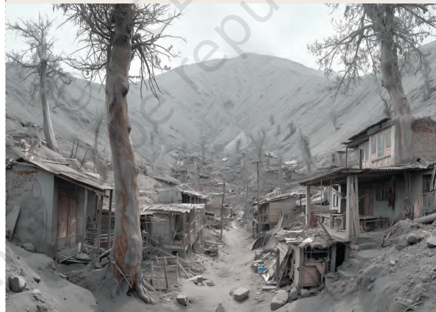
(i) What do you think caused this situation?
Ans: This situation was most likely caused by a volcanic eruption, which released ash, dust, and other volcanic materials over the surrounding area.
(ii) What could that grey powder be?
Ans: The grey powder is most likely volcanic ash—tiny particles of rock, minerals, and volcanic glass ejected during an eruption.
(iii) What does it tell us about the Earth’s internal forces?
Ans: It shows that the Earth has powerful internal (endogenic) forces. Heat and pressure inside the Earth can force magma to the surface through volcanoes, causing eruptions that can dramatically change landscapes and affect human settlements.
Questions and Activities
1. What are the sources of energy that are required to cause movements associated with the internal forces of the Earth?
Ans: (i) Heat energy from the Earth’s interior is the main source of internal movements.
(ii) This heat comes mainly from the Earth’s core and from the decay of radioactive elements inside the Earth.
(iii) The heat creates convection currents in the mantle, which move the tectonic plates.
(iv) These plate movements cause earthquakes, volcanic eruptions, folding, and faulting.
2. Relate various physiographic divisions you have studied in the earlier grades with various endogenic forces responsible for their origin.
Ans: (i) Mountains: Formed by folding, faulting, and volcanic activity due to tectonic plate movements.
(ii) Plateaus: Formed by volcanic eruptions and the uplift of the Earth’s crust.
(iii) Plains: Formed mainly by the deposition of sediments carried by rivers, though some are uplifted by internal forces.
(iv) Rift Valleys: Formed due to faulting when the Earth’s crust breaks and sinks between parallel faults.
(v) Volcanic Islands: Formed by repeated volcanic eruptions beneath the sea.
(vi) Ocean Basins: Formed due to the movement of tectonic plates and the spreading of the ocean floor.
3. Why and where do earthquakes occur frequently? Is it possible to predict earthquakes?
Ans: (i) Earthquakes occur due to the sudden movement of tectonic plates along plate boundaries.
(ii) They occur most frequently along convergent, divergent, and transform plate boundaries.
(iii) Most earthquakes occur around the Pacific Ring of Fire.
(iv) In India, earthquake-prone regions include the Himalayan region, North-East India, Gujarat, and the Andaman & Nicobar Islands.
(v) Scientists cannot accurately predict the exact time, place, and magnitude of an earthquake. However, earthquake-prone regions can be identified to reduce disaster risks.
4. “Plate movements are responsible for the distribution of earthquakes and volcanoes.” Explain.
Ans: (i) The Earth’s lithosphere is divided into several tectonic plates.
(ii) These plates move slowly due to convection currents in the mantle.
(iii) When plates collide, move apart, or slide past each other, stress builds up and is released as earthquakes.
(iv) At convergent and divergent boundaries, magma rises to the surface, forming volcanoes.
(v) Therefore, most earthquakes and volcanoes are found along plate boundaries, especially around the Pacific Ring of Fire.
5. Draw and label a diagram of a meander and a delta.
Ans: A meander is a bend in a river channel. Deposition occurs on occurs on the inside of the bend, Edit Sion occurs on the outside.
A delta is formed at the mouth of a river when it deposits a large amount of sediment. The river splits into many distributaries.
6. How are deforestation and erosion associated with each other? Explain.
Ans: (i) Deforestation means cutting down trees and removing vegetation.
(ii) Trees and plants hold the soil together with their roots.
(iii) When forests are removed, the soil becomes loose and exposed.
(iv) Rainwater and wind easily carry away the loose topsoil, causing erosion.
(v) Soil erosion reduces soil fertility, damages farmland, and may lead to landslides and floods.
(vi) Thus, deforestation increases soil erosion and harms the environment.
7. Develop a plan to protect the land in your local area from erosion.
Ans: (i) Plant more trees and protect existing forests (afforestation).
(ii) Avoid unnecessary cutting of trees (prevent deforestation).
(iii) Build contour trenches, bunds, and terraces on slopes to reduce soil erosion.
(iv) Construct check dams and proper drainage systems to control water flow.
(v) Grow grass and other vegetation on bare land to hold the soil together.
(vi) Prevent overgrazing and encourage sustainable farming practices.
(vii) Create awareness among local people about soil conservation.
(viii) Regularly monitor erosion-prone areas and take timely preventive measures.
8. Which disasters do you think you might experience in your region? Discuss a mitigation plan in your classroom.
Ans: (Example for Assam)
(i) Floods and landslides are the most common disasters in my region.
(ii) Earthquakes may also occur because Assam lies in a high seismic zone.
(iii) We should plant more trees to prevent soil erosion and landslides.
(iv) We should avoid building houses in flood-prone and landslide-prone areas.
(v) We should prepare emergency kits and follow evacuation plans.
(vi) We should participate in disaster awareness and safety drills.
(vii) We should follow the instructions of disaster management authorities during emergencies.
9. Prepare a model of landforms created by underground water.
Ans: Materials: Cardboard, clay, thermocol, paint, glue, labels.
(i) Make a cave using clay or thermocol.
(ii) Add stalactites hanging from the cave roof.
(iii) Add stalagmites rising from the cave floor.
(iv) Show a sinkhole (doline) on the land surface.
(v) Draw an underground river flowing through the cave.
(vi) Label all the landforms clearly.
10. What precautionary measures will you take if you are staying in an earthquake-prone region?
Ans: (i) Construct earthquake-resistant buildings.
(ii) Secure heavy furniture and electrical appliances.
(iii) Keep an emergency kit with food, water, medicines, and a torch.
(iv) During an earthquake, Drop, Cover, and Hold On under a strong table or desk.
(v) Stay away from windows, glass, and heavy objects.
(vi) Do not use lifts during or immediately after an earthquake.
(vii) Move to an open area after the shaking stops.
(viii) Follow the instructions of disaster management authorities and emergency services.

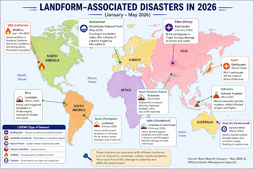
11. Prepare a map showing landform-associated disasters that happened in the current calendar year.
Ans:
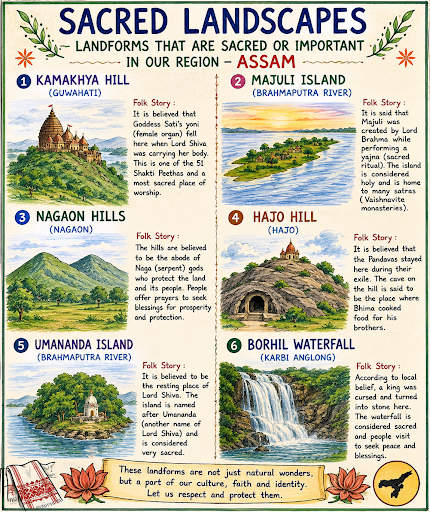
12. Create a poster showing landforms that are considered to be sacred or important in your region, and add the folk stories associated with them.
13. Document a case of a disaster that hit your region in the past, highlighting its effects on various human activities.
Ans: Case Study: Assam Floods (2024)
Disaster: Floods in Assam
Region: Assam (Brahmaputra Valley)
Year: 2024
Effects on Human Activities:
(i) Heavy rainfall and the overflowing Brahmaputra River caused severe flooding.
(ii) Thousands of people were displaced and had to stay in relief camps.
(iii) Houses, roads, bridges, and schools were damaged.
(iv) Large areas of agricultural land and crops were destroyed, causing financial losses to farmers.
(v) Transport and communication were disrupted due to submerged roads and damaged bridges.
(vi) Many livestock were lost, affecting the livelihood of rural families.
(vii) Water-borne diseases increased because of contaminated drinking water.
(viii) Rescue and relief operations were carried out by the government, NDRF, SDRF, and local volunteers to help affected people.
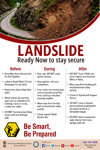
14. Translate the given poster on landslide into your native language and display it in your home.
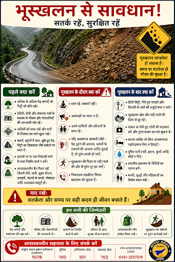
15. Divide the class into three groups. Each group will work on one project (water, wind, and glacier). The project should highlight the causes, impact on human life and the environment, and mitigation measures.
Ans: Group 1: Water Project
| Topic | Details |
| Causes | Heavy rainfall, floods, river erosion, overflowing rivers, coastal erosion. |
| Impact on Human Life | Damage to houses, roads, bridges, crops, and loss of life and property. |
| Impact on Environment | Soil erosion, destruction of forests, pollution of water bodies, loss of wildlife habitats. |
| Mitigation Measures | Afforestation, construction of embankments, proper drainage systems, rainwater harvesting, flood warning systems. |
Group 2: Wind Project
| Topic | Details |
| Causes | Strong winds, drought, loose dry soil, lack of vegetation. |
| Impact on Human Life | Damage to houses, reduced visibility, crop destruction, health problems due to dust. |
| Impact on Environment | Soil erosion, desertification, damage to vegetation, loss of fertile land. |
| Mitigation Measures | Plant shelter belts, grow more trees, protect vegetation, use proper farming practices, control overgrazing. |
Group 3: Glacier Project
| Topic | Details |
| Causes | Rising temperatures, glacier melting, heavy snowfall, Glacial Lake Outburst Floods (GLOFs). |
| Impact on Human Life | Floods, destruction of villages, roads, bridges, hydropower projects, and loss of life. |
| Impact on Environment | Habitat loss, river changes, soil erosion, ecosystem imbalance. |
| Mitigation Measures | Monitor glacial lakes, establish early warning systems, reduce greenhouse gas emissions, afforestation, disaster preparedness. |

 Buy Now