
Class 12 AHSEC 2020 Geography Question Paper Solved English Medium, AHSEC Class 12 Geography Question Paper Solved PDF Download, to each Paper is Assam Board Exam in the list of AHSEC so that you can easily browse through different subjects and select needs one. AHSEC Class 12 Geography Previous Years Question Paper Solved in English can be of great value to excel in the examination.
Class 12 AHSEC 2020 Geography Question Paper Solved English Medium


AHSEC Old Question Paper provided is as per the 2020 AHSEC Board Exam and covers all the questions from the AHSEC Class 12 Geography Solved Question Paper 2020 English Medium. Access the detailed Class 12 Geography 2020 Previous Years Question Paper Solved provided here and get a good grip on the subject. AHSEC 2020 Geography Question Paper Solved Access the AHSEC 2020 Geography Old Question Paper Solved, AHSEC Class 12 Geography Solved Question Paper 2020 of English in Page Format. Make use of them during your practice and score well in the exams.
GEOGRAPHY
2020
GEOGRAPHY OLD QUESTION PAPER SOLVED
1. Choose the correct answer from the four alternatives given below:
(a) Which one of the following continents has the highest growth in population.
(i) Asia.
(ii) Europe.
(iii) Africa.
(iv) South America.
Ans: (iii) Africa.
(b) Which one of the following types of industries products raw materials for other industries?
(i) Small scale industry.
(ii) Basic industry.
(iii) Cottage industry.
(iv) Footloose industry.
Ans: (i) Basic Industry.
(c) Which one of the following states of India has the highest rank in the Human Development Index?
(i) Kerala.
(ii) Gujarat.
(iii) Assam.
(iv) Bihar.
Ans: (i) Kerala.
(d) In which one of the following environments the presence of dispersed rural settlements cannot be expected?
(i) Alluvial plains of Ganga.
(ii) Arid and Semi arid regions of Rajasthan.
(iii) Lower valleys of the Himalayas.
(iv) Forests and hills of Northeast India.
Ans: (iv) Forest and hills of Northeast India.
2. Answer very briefly:
(a) What is Trans-Siberian Railway?
Ans: The Trans-Siberian Railway is the longest railway in the world. It is built between 1891 and 1916 to connect Moscow with the Far-East city of vladivostok.
(b) What do you understand by Population Doubling Time?
Ans: In geography, “doubling time” is a common term used when studying population growth. It is the projected amount of time that it will take for a given population to double. It is based on the annual growth rate and is calculated by what is known as “The Rule of 70.”
(c) What is the present name of erstwhile ‘Rajasthan Canal’?
Ans: Gandhi Canal.
(d) Which type of pollution causes acid rain?
Ans: Acid rain occurs when sulphur dioxide and nitrogen oxides mix with the molecules in the atmosphere and increase the acidity of precipitation.
3. Answer in brief:
(a) How is human geography related to other social sciences?
Ans: Human Geography assumes a highly inter- disciplinary nature. It develops close interface with other sister disciplines in social sciences in order to understand and explain human elements on the surface of the earth.
Thus human Geography is related to other social sciences in the following ways:
a. Sociology.
b. Psychology.
c. Welfare Economics.
d. Anthropology.
e. History.
(b) How do you calculate the density of population in a region?
Ans: Density of Population are:
(i) Each unit of land has limited capacity to support a certain number of people.
(i) Hence, it is necessary to understand the ratio between the numbers of people to the size of land.
(iii) This ratio is termed as density of population.
(iv) It is usually measured in number of persons per square kilometre.
Density of Population = Population/Area
(c) What do you understand by Co-operative Farming?
Ans: The major features of cooperative farming are:
(i) A group of farmers form a co-operative society by pooling in their resources voluntarily for more efficient and profitable farming system. This is called co-operative farming.
(ii) Co-operative society help farmers in all aspects to procure all important inputs of farming.
(iii) The society help farmers to sell the finish product at the most favourable terms and help in processing of quality product at cheaper rates.
(iv) This type of farming is famous in western countries like Denmark. Netherland, Belgium, Sweden etc.
(d) What is Quaternary activity?
Ans: The quinary activity involves the highest level of decision-makers or policymakers. This is very different from quaternary activities. Quinary services focus on creating, re-arranging, and interpreting new and existing ideas, data interpretation, and the use and evaluation of newer technologies. These professions are very limited in nature, but their importance and role in the structure of advanced economies outweigh their count far away.
(e) What do you understand by Traffic flow?
Ans: Traffic flow is the study of the movement of individual drivers and vehicles between two points and the interactions they make with one another.
(1) Why ports are called as the gateway of international trade?
Ans: The reasons :
(i) The chief gateways of the world of international trade are the harbours and ports.
(ii) Cargoes and travellers pass from one part of the world to another through these ports.
(iii) The ports provide facilities of docking, loading, unloading and the storage facilities for cargo.
Ports as gateways of international trade-The chief gateways of the world of international trade are the harbours and ports. Cargoes and travellers pass from one part of the world to another through these ports. The ports provide facilities of docking loading unloading and the storage facilities for cargo. Due to above importance ports are called gateways of international trade.
(g) What do you understand by a Healthy City?
Ans: A healthy city is one that is continually creating and improving those physical and social environment and expanding those community resources which enable people to mutually support each other in performing all the functions of life and developing to their maximum potential.
(h) What do you understand by personal communication system?
Ans: It is the communication between person to person. It provides necessary communication between two people making man a social animal. We have letters e-mail, SMS, telephone and mobile phone facilities which also includes STD and ISD service.
(i) What are the importance of Mumbai Sea Port?
Ans : Mumbai port has played an important role in the development of trade and commerce in the country. The port which was designed to handle general cargo, has adapted to the changing time. It is now also capable of handling containerised cargo.
(j) What are the Physical and Economic factors affecting mining-activity?
Ans: Physical Factor: Include the size, grade and the mode of occurrence of the deposits.
Economic Factors: Such as the demand for the mineral, technology available and used, capital to develop infrastructure and the labour and transport costs.
4. Answer the following questions in about 100 words each :
(a) Write the importance of Tourism as a tertiary activity.
Ans: Tourism is included in tertiary activities. Tourism has become the world’s single largest tertiary activity in total registered jobs and total revenue. It is travel undertaken for purpose of recreation rather than business or other purpose. Tourism industry is industry. Besides, many local persons, are employed to provide services like accommodation, meals, transport, entertainment and special shops serving the tourist. It fosters the growth of infrastructure industries, retail trading and craft industries.
The warmer places around the Mediterranean coast and the west coast of India, historical picturesque towns and archeological sites are attracted the tourist. Since the last century, the demand for holiday has increased rapidly, permit many more people to go holidays for leisure, so now a days tourism is signified as the important services.
(b) What is Satellite Communication and write briefly on the development of this type of communication in India?
Ans: Satellite communication is transporting information from one place to another using a communication satellite in orbit around the Earth. Watching the English Premier League every weekend with your friends would have been impossible without this. A communication satellite is an artificial satellite that transmits the signal via a transponder by creating a channel between the transmitter and the receiver at different Earth locations.
Telephone, radio, television, internet, and military applications use satellite communications. Believe it or not, more than 2000 artificial satellites are hurtling around in space above your heads.
The idea of communicating through a satellite first appeared in the short story titled “The Brick Moon,” written by the American clergyman and author Edward Everett Hale and published in The Atlantic Monthly in 1869–70. The story describes the construction and launch into Earth orbit of a satellite 200 feet (60 metres) in diameter and made of bricks. The brick moon aided mariners in navigation, as people sent Morse code signals back to Earth by jumping up and down on the satellite’s surface.
The first practical concept of satellite communication was proposed by 27-year-old Royal Air Force officer Arthur C. Clarke in a paper titled “Extra-Terrestrial Relays: Can Rocket Stations Give World-wide Radio Coverage?” published in the October 1945 issue of Wireless World. Clarke, who would later become an accomplished science fiction writer, proposed that a satellite at an altitude of 35,786 km (22,236 miles) above Earth’s surface would be moving at the same speed as Earth’s rotation. At this altitude the satellite would remain in a fixed position relative to a point on Earth. This orbit, now called a “geostationary orbit,” is ideal for satellite communications, since an antenna on the ground can be pointed to a satellite 24 hours a day without having to track its position. Clarke calculated in his paper that three satellites spaced equidistantly in geostationary orbit would be able to provide radio coverage that would be almost worldwide with the sole exception of some of the polar regions.
(c) What is urbanisation and mention two causes of urbanisation?
Ans: Urbanization: Urbanization is a word for becoming more like a city. When populations of people grow, the population of a place may spill over from city to nearby areas. This is called urbanization.
Two causes of Urbanization:
Industrial growth: The explosion of industrialization and manufacturing enterprises within a certain urban area gives rise to more employment opportunities which is another factor of Urbanization.
Employment: Rural areas commonly are agricultural Urbanization and industrial growth create opportunities for jobs that pay more, are more diverse, and may be less physically demanding.
(d) Classify the towns in India on the basis of population size.
Ans: Human development index measuring average achievement in three basic dimension of human development-These are, a long life or healthy life, knowledge and a decent standard of living. It is used to distinguish whether the country is a developed, a developing or an underdeveloped country and also to measure the impact of economic policies on quality of life.
Countries fall into four broad human categories- very high, high, Medium, and Lao.
Human development: categories, criteria and number of countries are shown in the following table:
| Level of Human Development | Score in Development Index | Number of countries |
| Very high | Above 0.793 | 47 |
| High | 0.698-0.793 | 47 |
| Medium | 0.522-0.698 | 47 |
| Low | Below 0.522 | 46 |
The closer is to one, the greater is the level of human development. High level of development group has 47 countries. Providing education and healthcare is the main priority of such countries. A lot of investment in the social sector has-taken place.
There are large number of countries in the medium level of human development. Most of these are countries which have emerged in the period after the second world war.
(e) Write a brief note on the Barak Valley of Assam.
Ans: The Barak Valley forms one of the important physiographic units of Assam. The valley comprising the Barak plain and the northern and southern foothills is the product of the fluvio geomorphic processes of the river Barak and its tributaries. The plain is enclosed by hill ranges on three sides – The Meghalaya Plateau and the Barail range of the NC Hills district on the North. Manipur Hills on the east and the Mizo Hills on the south. The Barak valley is the headward piedmont part of the Barak- Surama-Kushiyara plain which lies largely in Bangladesh. The Barak plain shapes down gently to the west and river Barak flows sluggishly in meandering course through it leaving a series of ox-blow lakes and swamps.
(f) Write briefly on the importance of petroleum industry in Assam.
Ans: Assam state of India is rich in mineral resources. Petroleum or crude oil is the most important of them all. In fact, Assam is the mother of Indian petroleum industry. In India, petroleum was first discovered in Assam. It was Digboi in Assam where the first Oil Refinery in Asia came up. Indian petroleum companies like OIL and ONGC were born out of Assam.
History of Petroleum in Assam: In 1825, British Lieutenant Wilcox accidentally discovered petroleum in Assam. In 1866 first oil well was dug near Jaypore. In following years several attempts were made to extract oil. But actual oil exploration and extraction started with Digboi Well No-1 in 1889. By 1893, several wells were drilled in Digboi area. Together they were producing around 757 liters per day. Digboi refinery was established to refine the crude oil locally.
Digboi refinery is still working. The oil production in Assam is got a boost with discovery of more oil fields in Naharkatia and Moran. February, 1959, Oil India Private Limited (OIL) was incorporated to develop the newly discovered oil fields. As the result of continuous exploration activities, oil was later found in many others places of Assam.
(g) Write briefly on three main mineral regions of India.
Ans: The North Eastern Plateau Region: (i) This belt covers Jharkhand and Orissa Plateau region (comprising Chota Nagpur Plateau), West Bengal and parts of Chattisgarh.
(ii) Major iron and steel industry has been set up in this region because of these reasons:
(a) Availability of raw materials – iron ore, manganese, limestone.
(b) Coking coal.
(c) Water from nearby rivers.
(d) Cheap labour.
(e) Easy availability of transportation means like railways.
(iii) In this region various minerals like iron, coal, manganese, bauxite, mica are abundantly found.
The South Western Plateau Region: (i) Karnataka, Goa and contiguous Tamil Nadu uplands and Kerala for this belt.
(ii) The belt is rich in ferrous minerals and bauxite.
(iii) The important ferrous minerals include iron ore, manganese and limestone.
(iv) The belt does not contain coal deposits except low grade lignite coal at Neyveli lignite coalified.
(v) Kerala has deposits of monazite and thorium, bauxite.
(vi) Goa is known for iron ore deposits.
The North Western Region: (i) North Western Region extends over Rajasthan and parts of Gujarat.
(ii) These mineral deposits belong to Dharwar systems of rocks.
(iii) Major minerals found in this region and copper and zinc.
(h) Write a short note on rural and urban settlements of Assam.
Ans: Urban: Urbanisation has been very slow in Assam. There has been very slow progress in the first half of the 20th century. In 1901 there were only 10 towns in the state with 2.34% of the population living in them. In 1951, the number of towns doubled and the urban population accounted for only 4.29%.
It was immediately after independence that the number of towns rose from 24 in 1951 to 52 in 1961 and the urban population increased by 126.57% during that decade to account for 7.16% of the states total. The post independence developmental activities and the influx of refugees from the then East Pakistan who settled in the Suburban areas, commercial centres and railway stations, junctions etc.
From 1961 onward, there has been a slow but steady progress of urbanization. Between 1961 and 2001, the total number of towns more than doubled and few towns emerged as large ones. Between 1971 and 2001. The urban population increased by more than 4 times from 7.8 lakhs to 33.89 lakhs, while the total population grew by only 2.6 times during the corresponding time period of all the districts, Kamrup with 7 towns and a city is the most urbanised with 35 81% urban population followed by N.C. Hills (31.19%), Tinsukia (19.49%), Dibrugarh (18.77%) & Jorhat (16.99%)
The least urbanised district of Assam are Nalbari (2.41%), Morigaon (4.91%), Darrang (4.91%), Kokrajhar (6.84%) and Dhemaji (6.91%)
Rural: Assam is still a region largely of agricultural economy. The rural population constitutes 87.28% of the total population of the state (2001). There are, in Assam, new 26.247 villages. The villages are generally small. In fact, about 4/5# the total number of villages have less than 1000 population in each.
The rural settlements of the state like anywhere else in the developing countries across the world vary in form and pattern from place to place. The settlement factors influencing the rural settlement pattern of Assam are the following :
(a) Physiography of the village site.
(b) Alignment of the river flowing near a village.
(c) Alignment of road or railway running near a village.
(i) Mention the characteristics of India’s foreign trade.
Ans: The noted characteristics of India’s foreign trade are :
(i) India’s foreign trade increase in total volume of imports and exports.
(ii) India imports more items than its exports. (iii) Due to rise in prices of crude petroleum in international market. India’s trade deficit increases which is another characteristics of India’s foreign trade.
(j) Write a short note on water transport of Assam.
Ans: It is estimated that the North-Eastern region has about 1800 km of river routes that can be used by steamers and large country boats. The inland water transport departments of both the state and central governments have been trying to improve the water transport system in the region.
The river Brahmaputra now has several small river-ports like Dibrugarh, Disangmukh Nemati. Biswanath, Silghat Guwahati, Goalpara and Dhubri Besides, there are more than 30 pairs of ferry ghats on the Brahmaputra, transporting men and materials between its two banks. The river Barak also has small ports at Karimganj Badarpur and Silchar and Ferry services at several places across it. At present the state Tourist Department has started Luxury cruises over the Brahmaputra as a commercial proposition.
5. Answer the following questions :
(a) Discuss the geographical and economic factors influencing the distribution of population.
Ans: (i) Availability of water: It is the most important factors for all living being. So, people prefer to live in those areas where waters are available especially the fresh water.
(ii) Landforms: People prefer living on flat plains and gentle slopes. The uneven topography are always hinder the all types developments. So, these areas tend to be less populated.
(b) Economic Factors:
(i) Minerals: Minerals are not available all over the world. Some areas are endowed with more minerals while some areas are devoid of minerals. So, areas with more mineral deposits are thickly populated.
(ii) Urbanisation: Cities offer better opportunities in all respects. So, all the urbanised areas are thickly populated.
(iii) Industrialisation: Industrialisation provide job opportunities and attract large number of people. In other words such areas are thickly populated.
(c) Social and Cultural Factors: There are many places are found over the surface of the earth which attract more people because they have religious or cultural significance. In the same way- people tend to move away from places where there is social and political unrest. Thus, such social and cultural factors are also responsible for high population or low population density of a region.
(b) Discuss the problems of Indian agriculture.
Ans: The major problems confronting Indian agriculture are those of population pressure, small holdings, depleted soils, lack of modern technology and poor facilities for storage.
(a) Population Pressure: India has a huge population of over one billion and it is increasing at a very fast rate. According to 2001 census figures the overall density of population is 324 persons per sq. km. This is likely to increase further in future. This has created great demand for land. Every bit of land has been brought under the plough. Even the hill slopes have been cut into terraces for cultivation.
(b) Small and Fragmented Land Holdings: The pressure of increasing population and the practice of dividing land equally among the heirs has caused excessive sub divisions of farm holdings. Consequently, the holdings are small and fragmented. The small size of holdings makes farming activity uneconomical and leads to social tension, violence and discontentment.
(c) Inadequate Irrigation Facilities: By and large the irrigation facilities available in India are far from adequate. So for half of the total area under food crops has been brought under irrigation and the remaining half is left to the mercy of monsoon rains which are erratic in time and space.
(d) Depleted Soils: Indian soils have been used for growing crops for thousands of years which have resulted in the depletion of soil fertility. With deforestation the sources of maintaining natural fertility of soil has been drying out. Lack of material resources and ignorance of scientific knowledge have further depleted the soils of the natural fertility. Earlier only animal waste was enough to maintain soil fertility.
(e) Storage of food grains: Storage of food grains is a big problem. Nearly 10 percent of our harvest goes waste every year in the absence of proper storage facilities. This colossal wastage can be avoided by developing scientific ware-housing facilities. The government has taken several steps to provide storage facilities.
(c) Discuss the nature of water pollution in India.
Ans: (i) Sewage And Waste Water: Sewage, garbage and liquid waste of households, agriculture lands and factories are discharged into lakes and rivers. These wastes contain harmful chemicals and toxins which make the water poisonous for aquatic animals and plants.
(ii) Dumping: Dumping of solid wastes and litters in water bodies causes huge problems. Litters include glass, plastic, aluminium, styrofoam etc. Different things take different amount of time to degrade in water. They affect aquatic plants and animals.
(iii) Industrial Waste: Industrial waste contains pollutants like asbestos, lead, mercury and petrochemicals which are extremely harmful to both people and environment. Industrial waste is
discharged into lakes and rivers by using fresh water making the water contaminated.
(iv) Oil Pollution: Sen water gets polluted due to oil spilled from ships and tankers while travelling. The spilled oil does not dissolve in water and forms a thick sludge polluting the water.
(v) Acid Rain: Acid rain is pollution of water caused by air pollution. When the acidic particles caused by air pollution in the atmosphere mix with water vapor, it results in acid rain.
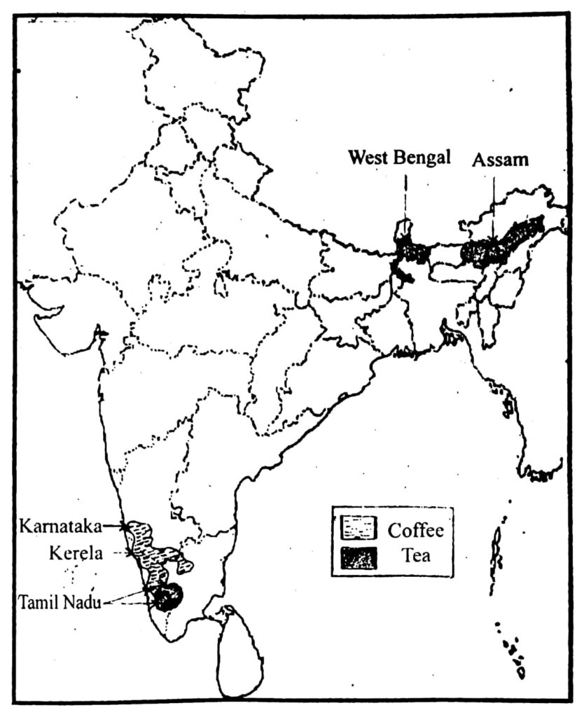
(d) Draw an outline map of India and mark the following therein :
(i) A port of western coast.
(ii) A coal mine.
(iii) A westward flowing river of South India.
Ans:

Hi! my Name is Parimal Roy. I have completed my Bachelor’s degree in Philosophy (B.A.) from Silapathar General College. Currently, I am working as an HR Manager at Dev Library. It is a website that provides study materials for students from Class 3 to 12, including SCERT and NCERT notes. It also offers resources for BA, B.Com, B.Sc, and Computer Science, along with postgraduate notes. Besides study materials, the website has novels, eBooks, health and finance articles, biographies, quotes, and more.


