Class 11 Geography Chapter 9 Solar Radiation, Heat balance, and Temperature The answer to each chapter is provided in the list so that you can easily browse throughout different chapters SCERT Class 11 Geography Chapter 9 Solar Radiation, Heat balance, and Temperature and select need one.
Class 11 Geography Chapter 9 Solar Radiation, Heat balance, and Temperature
Also, you can read the SCERT book online in these sections Solutions by Expert Teachers as per SCERT (CBSE) Book guidelines. These solutions are part of SCERT All Subject Solutions. Here we have given Assam Board/NCERT Class 11 Geography Chapter 9 Solar Radiation, Heat balance, and Temperature Solutions for All Subject, You can practice these here…
Solar Radiation, Heat balance and Temperature
Chapter: 9
PART-1
GEOGRAPHY
TEXTUAL QUESTION & ANSWER
Q.1. The sun is directly observed at noon at on 21st June at-
(i) The Equator
(ii) 23.5°5
(iii) 23.5°
(iv) 66.5°N
Ans: (i) The Equator
Q.2. In which one of the following cities are the days the longest?
(i) Thiruvananthapuram
(ii) Chandigarh
(iii) Hyderabad
(iv) Nagpur
Ans: (i) Thiruvananthapuram
Q.3. The atmosphere is mainly heated by the-
(i) Shortwave solar radiation
(ii) Reflected solar radiation
(iii) Long wave terrestrial radiation.
(iv) Scattered solar radiation.
Ans:(iii) Long wave terrestrial radiation.
Q.3. Make correct pairs from the following two columns:
(i) Insolation
(ii) Albedo
(iii) Isotherm
(iv) Annual range
(a) The difference between the mean temperature of the warmest and the coldest months.
(b) The lines joining the places of equal temperature.
(c) The incoming solar radiation.
(d) The percentage of visible light reflected by an object.
Ans: 1. Insolation
2.Albedo
3. Isotherm
4. Annual range
(c)The incoming solar radiation
(d)The percentage of visible light reflected by an object
(b)The lines joining the places vof equator temperature
(a)The difference between the mean temperature of the warmest and coldest months.
Q.5. The main reason that the earth experiences highest temperatures in the sub-tropics in the northern hemisphere rather than at the equator is-
(a) Subtropical areas trend have less cloud cover then equatorial areas.
(b)Subtropical areas have longer day hours in the summer than equatorial.
(c) sub tropical areas have an enhanced ‘greenhouse effect’ compared to equatorial areas.
(d) Subtropical areas are nearest to oceanic areas than the equatorial locations.
Ans: Sub tropical areas have an enhanced ‘greenhouse effect’ compared to equatorial areas.
(b) Answer the following questions in about 30 words
Q.1. How does the unequal distribution of heat over the planet earth in space and time variations in weather and climate?
Ans: The earth receives almost all of its energy from the sun. Due to the peculiar shape of the earth the amount of heat received by different parts of the earth is not same. Some parts of the earth’s surface receive more temperature throughout the year, while other parts receive less amount of sun’s rays. Due to the unequal distribution of sun’s ray, it affect in weather and climate of the planet earth.
Q.2. What are the factors that control temperature distribution on the surface of the earth?
Ans: The factors which control temperature distribution on the surface of the earth are:
(a) The latitude
(b) The altitude
(c) Distance foam the sea/ocean
(d) Ocean currents
(e) Influence of air mass
(f) Local aspects
Q.3. In India, why is the day temperature maximum in may and why not after the summer solstice?
Ans: The Siberian plains are far away from water bodies moreover the area is Landlocked. That is why during winter the temperature goes up to minus 20°C and the summer temperature recorded up to 10°C. So, the plains experience a high range of annual temperature.
| Sl. No. | CONTENTS |
| Chapter 1 | Geography As A Discipline |
| Chapter 2 | The Origin and Evolution of the Earth |
| Chapter 3 | Interior of the Earth |
| Chapter 4 | Distribution of Oceans And Continents |
| Chapter 5 | Minerals and Rocks |
| Chapter 6 | Geomorphic Processes |
| Chapter 7 | Landforms and Their Evolution |
| Chapter 8 | Composition and Structure of Atmosphere |
| Chapter 9 | Solar Radiation, Heat balance, and Temperature |
| Chapter 10 | Atmospheric Circulation and Weather Systems |
| Chapter 11 | Water in the Atmosphere |
| Chapter 12 | World Climate and Climate Change |
| Chapter 13 | Water (Oceans) |
| Chapter 14 | Movements of Ocean Water |
| Chapter 15 | Life on the Earth |
| Chapter 16 | Biodiversity And Conservation |
| Chapter 17 | Indian Location |
| Chapter 18 | Structure and Physiography |
| Chapter 19 | Drainage System |
| Chapter 20 | Climate |
| Chapter 21 | Natural Vegetation |
| Chapter 22 | Soils |
| Chapter 23 | Natural Hazards and Disasters |
(c) Answer the following portion in about 150 words:
Q.1. How do the latitude and the tilt in the axis of rotation of the earth affect the amount of radiation received at the earth’s surface?
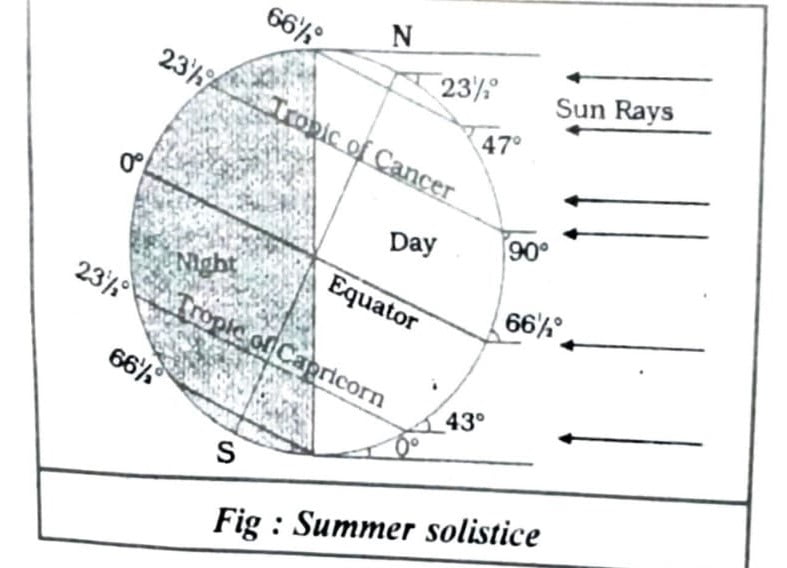
Ans: The amount of insolation received by a place depends upon the angle of inclination of the rays. This depends on the latitude of a place. The higher the latitude, the less is the angle they make with the surface of the earth. The area covered by vertical rays is always less than the slant rays. If more area is covered the energy gets distributed and the net energy received per unit area decreases. Moreover, the slant rays are required to pass through greater depth of the atmosphere resulting in more absorption scattering and diffusion. As a result, high latitudinal areas get less insolation as compared to low latitudinal areas.

Again, the duration of sunshine or the length of days over the earth’s surface are not the same everywhere. Due to the tilt of the inclination in the axis of the earth, the equatorial areas receive more sun rays than the other areas. The length of the days is almost 12 hours on the equator and the length of days increases poleward with the northward march of the sun in the northern hemisphere, and it decreases in the southern hemisphere at the time of summer solstice and vice- versa (Table-1)
| Latitude | December 22 | June 21 |
| 0° | 12h 00m | 12h |
| 20° | 10h 48m | 13h 12m |
| 40° | 9h 8m | 14h 52m |
| 60° | 5h 33m | 18h 27m |
| 90° | 0 | 6month |
Q.2. Discuss the processes through which the earth-atmosphere system maintains heat balance.
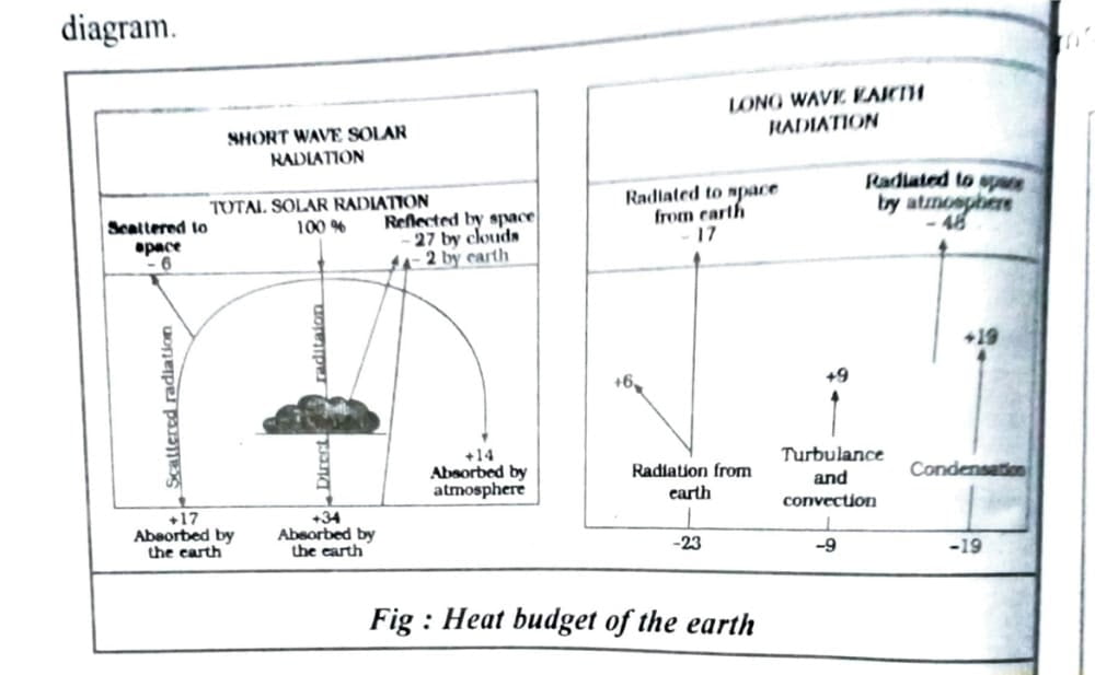
Ans: The earth receives most of its energy from the sun in short wavelengths and heats up it’s surface. The energy to the atmosphere in the atmosphere in the form of longwave.
Suppose, the insolation received in the atmosphere is 100 units. While passing through the atmosphere some amount of energy is reflected, scattered and absorbed. Only the remaining part reaches the earth surface. Roughly, 35 units are reflected back to space even before reaching the earth’s surface.Of these, 27 units are reflected back from the top of the clouds and 2 units form the snow and ice-covered areas of the earth.
The remaining 65 units are absorbed, 14 units within the atmosphere and 51 units by the earth’s surface. The earth radiates back 51 units in the forms of terrestrial radiation. Of these, 17 units are radiated to space directly and the remaining 34 units are absorbed by the atmosphere. 48 units absorbed by the atmosphere are also radiated back into space. Thus, the total radiation returning from the earth and the atmosphere respectively is 17+48=65 units which balance the total of 65 units received from the sun. By this way the earth neither warms up nor cools down despite the huge transfer of heat that takes place. The heat balance of the earth is represented in the following diagram.

Q.3. Compare the global distribution of the temperature in January over the northern and the southern hemisphere of the earth.
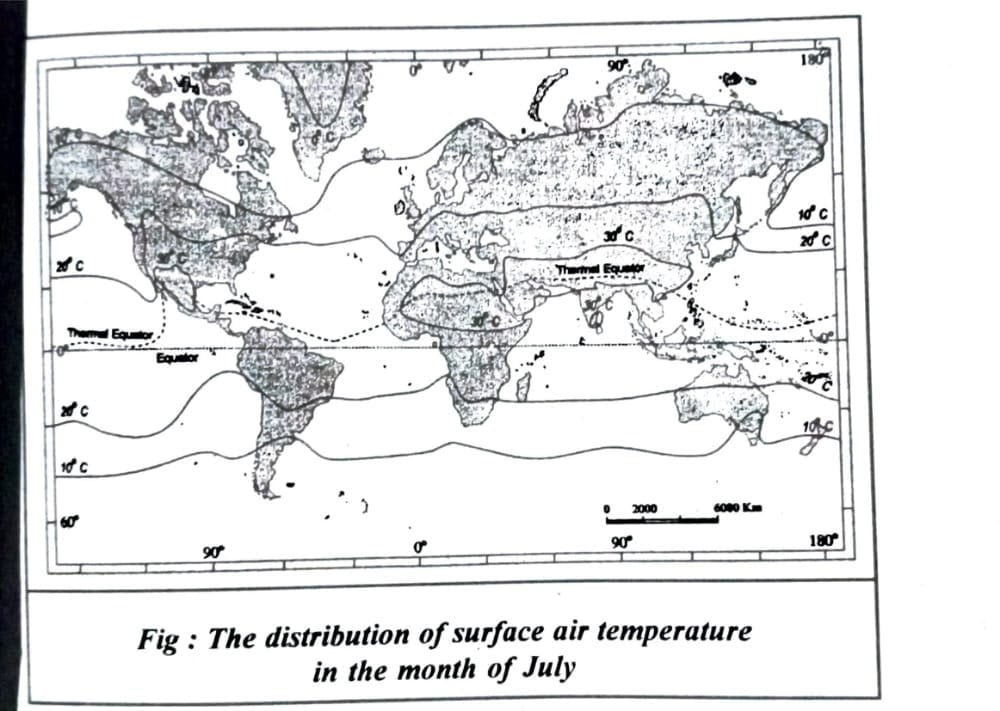
Ans: In the northern hemisphere the land surface area is much larger than in the southern hemisphere. Hence, the efforts of landmass and the ocean currents are well pronounced. In January the isotherms deviate to the north over the ocean and to the south over the continents. Over the land time temperature decreases sharply and the isotherms bend towards the South (in Europe). It is minus 20°C.
The mean monthly temperature for January is over 27°C in equatorial oceans over 24°C in the tropics and 2°C-0°C in the middle attitudes and-18°C to 48°C in the Eurasian continental interior. The effect of the ocean is well pronounced in the southern hemisphere. The effect of the ocean is well pronounced in the southern hemisphere. Here the isotherms are more or less parallel to the latitudes and the variation in temperature is more gradual than in the northern hemisphere. The isotherms of 20°C. 10°C and 0°C run parallel to 35°S.,45°S and 60°S latitudes respectively. The distribution of temperature over globe for the month of January is shown in the following map.


Hi, I’m Dev Kirtonia, Founder & CEO of Dev Library. A website that provides all SCERT, NCERT 3 to 12, and BA, B.com, B.Sc, and Computer Science with Post Graduate Notes & Suggestions, Novel, eBooks, Biography, Quotes, Study Materials, and more.


