
Class 10 Elective Geography Chapter 5 Regional Geography of Japan Question Answer to each chapter is provided in the list so that you can easily browse throughout different chapters Assam Board Class 10 Geography Question Answer Chapter 5 Regional Geography of Japan and select needs one.
Class 10 Elective Geography Chapter 5 Regional Geography of Japan


Also, you can read the SCERT book online in these sections Solutions by Expert Teachers as per SCERT (CBSE) Book guidelines. These solutions are part of SCERT All Subject Solutions. Here we have given Assam Board Class 10 Geography Elective Chapter 5 Regional Geography of Japan Solutions for All Subject, You can practice these here.
Regional Geography of Japan
Chapter: 5
Textual Questions And Answers
1. State the geographical location of Japan.
Ans. Japan is an archipelago, or string of islands, on the eastern edge of Asia. There are four main islands: Hokkaido, Honshu, Shikoku, and Kyushu. There are also nearly 4,000 smaller islands! Japan’s nearest mainland neighbors are the Siberian region of Russia in the north and Korea and China farther south.
Almost four-fifths of Japan is covered with mountains. The Japanese Alps run down the center of the largest island, Honshu. The highest peak is Mount Fuji, a cone-shaped volcano considered sacred by many Japanese.
Japan can be a dangerous place. Three of the tectonic plates that form Earth’s crust meet nearby and often move against each other, causing earthquakes. More than a thousand earthquakes hit Japan every year. Japan also has about 200 volcanoes, 60 of which are active.
2. Give a geographical description of Japan.
Ans. Japan, located off the East coast of Asia, is an archipelago nation comprised of four main islands, from North to South: Hokkaido, Honshu (the largest and most populous), Kyushu, Shikoku, and over 3500 smaller islands. The southernmost reach is the Ryukyu Islands. Japan stretches over 2,360 miles, so the people enjoy climatic variety. Superimposed on eastern United States, Japan stretches from central Maine to Florida. The Japanese people define their country as a “small, resource-poor island country.” Japan has inferior coal seams, little iron ore, and nonexistent petroleum resources; it is reliant on imports, and on hydroelectric and nuclear energy production.
On a world map, Japan seems a small nation, dwarfed by China and Russia with North America facing over the vast Pacific, but Japan is larger in land mass (145,869 sq. mi/377,800 sq. km) than many of the world’s 180 countries, including the United Kingdom and Italy.
Mountains occupy over 80% of Japan’s landmass. Most of the mountains, such as the Japan Alps, were “uplifted” by the collision of the Pacific oceanic crust and continental crust of Asia. Some of Japan’s mountains are clearly volcanic, such as the iconic Mt. Fuji (12,385 ft.), which last erupted in 1707. Much of Japan is long, narrow valleys between tree-covered low mountains, (either natural or reforested), with strips of agriculture and human habitation along the valley edges.
3. What are the major physical divisions of Japan ? Briefly describe with map the landform of each division.
And. Japan is made up of 3,000 islands, which form a long chain along the eastern coast of Asia. Honshu, Hokkaido, Kyushu and Shikoku are four big islands of Japan. Japan is a mountainous country with few narrow coastal plains. The Kwanto plain is the most important plain. The land is both beautiful and unstable. Volcanoes and earthquakes are common throughout Japan. The rivers are soft and swift and are not navigable but are important sources of power and irrigation.
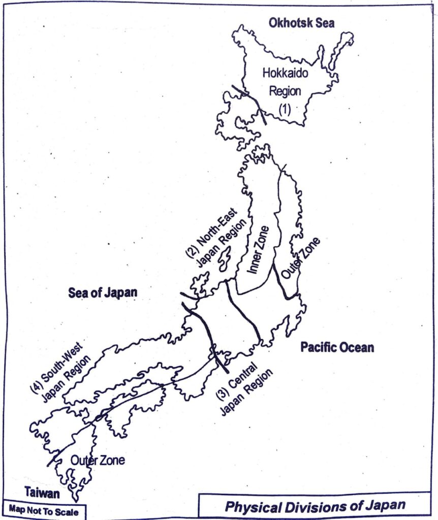
(i) Hokkaido region: Hokkaido boasts a vast area of 83,424 square kilometers, constituting about 22% of the land in Japan. Mountains occupy half the area of Hokkaido, which is surrounded by the vast expanse of the Pacific Ocean, the Sea of Japan, and the Sea of Okhotsk. Bordering on the northern limits of a temperate climate and the southern limits of a subarctic climate, Hokkaido is characterized by a cool climate with low humidity and is covered in snow for many months until it finally begins to melt in spring. Each of the four distinct seasons nurtures a rich harvest of foods with regional characteristics.
(ii) The north-east Japan region: The Northeastern Region nearly coincides with the northeastern mountain arc and stretches from southwest Hokkaido to central Honshu. Several rows of mountains, lowlands, and volcanic zones are closely oriented to the general trend of the insular arc of this region, which is convex toward the Pacific Ocean.
(iii) Central Japan region: The central part of Honshu island is known as the Central Japan. Here the Honshu mountainsand Shicito Mariana mountain ranges fused together to create the highest mountain region of Japan. The highest portion of it towards the east is known as the Hida mountain. A river valley given the name of Fossa Magna has separated the mountain ranges. Towards the south of the Fossa Magna there lies the Mount Fuji, the holy mountain peak of the Japanese. This peak is composed of lava. Its height is 3776 metres above the sea level. Kwanto plain and Nabi plain are the two important plains of central Japan. Running through this region, the river Tone and others have created the flood plain which is extended upto the coast of the Pacific Ocean. This region is very suitable for agriculture. Yokohama, Tokyo, Nagoya and Toyama are the famous cities in the region.
(iv) South-west Japan region: The south-west Japan region comprises South-west part of Honshu island (i.e. Chugoku- Honshu), Shikoku and Kyushu island. The mountain ranges of this region are the longest mountain ranges of Japan. Most of the areas of South-west Japan are formed by ancient rocks. The important plains of this region are Kyoto, Nara and Biwa etc. have been formed from rift valleys. The natural beauty created by a large number of island shaped rocky hills and rugged coasts is very attractive in this region.
4. Give a brief description of the landforms of Japan.
Ans: Description on landforms of Japan:
- Japan has a complex and varied geography because it is built on a series of tectonic plates which gave the country its arc-like appearance.
- Japan has different landforms from sandy beaches to famous mountains. Mount Fuji is most iconic symbol of Japan’s topography.
- Japan is a country of small islands and it is surrounded by sea on all sides, which give rise to coral reefs and iconic beaches.
- The bay city Hyuga was carved out by natural tides and was perfected over the period of centuries.
5. Write briefly about population growth and distribution of Japan.
Ans: From 1960 to 2022 the population of Japan increased from 93.22 million to 125.12 million people. This is a growth of 34.2 percent in 62 years. The highest increase in Japan was recorded in 1971 with 2.22 percent. The biggest decrease in 2021 with -0.46 percent. In the same period, the total population of all countries worldwide increased by 162.2 percent.
The average age in Japan rose by 3.97 years from 2012 to 2023 from 45.53 to 49.50 years (median value).
Around 92 percent of the inhabitants live in the country’s larger cities. This trend of urbanization is declining, decreasing by -0.3 percent per year.
Japan is suffering from a worrying population decline. The island nation in the western Pacific reached its highest growth rate by far in 1972. Since then, the population growth rate has been falling slowly but steadily. In the last 10 years, it reached values below zero, so the population has been shrinking for some time. Forecasts predict a further decline of 40 million inhabitants by 2060. Since 2005, more people have also been dying each year than infants have been born. This, too, is not an aberration or a short-term effect, but a development that has been announced over decades and will continue to intensify in the coming years.
Japan has the oldest population in the world. Not only does the average age top the list at 48, but so does life expectancy. Men today can look forward to a life span of 81.5 years. Women even live to be 87.6 years old.
6. Mention the factors which affect the density of population of Japan.
Ans: Japan has a population of 128 million as per 2007 estimate. This makes Japan the tenth most populated country in the world. The density of population of Japan is 338 persons per sq.km. One of the noticeable features of the Japanese population is its uneven distribution. The density of population of Japan varies from place to place.
The main reasons for this variation in density of population are:
(i) Mountainous nature of land: Nearly 75% of the land area of Japan is mountainous in nature.This makes the area unsuitable for human settlement and economic development. Hence, the density of population in these areas is less than 100 persons per sq.km.
(ii) High state of industrialisation: Today, Japan is one of the most industrialised nations in the world. High industrialisation brings about better employment opportunities leading to migration of people to urban areas and a high concentration of people in the towns and cities.
(iii) Urbanisation: The urban population of Japan is around 79% people have flocked to towns and cities because of the economic advantages of settling down in these places resulting in diminished agricultural production. Therefore, towns and cities of Japan have high density of population.
(iv) Climatic conditions: Climate is one of the important elements that affect the density of population of a country. The northern part of Japan has extreme cold climate and so this region has little population. On the other hand, the coastal regions of most of the islands of Japan have pleasant climate leading to high concentration of population in these areas.
7. Write about the role of agriculture in the economy of Japan.
Ans: Agriculture, forestry, and fishing dominated the Japanese economy until the 1940s, but thereafter declined into relative unimportance (see Agriculture in the Empire of Japan). In the late 19th century (Meiji period), these sectors had accounted for more than 80% of employment. Employment in agriculture declined in the prewar period, but the sector was still the largest employer (about 50% of the work force) by the end of World War II. It was further declined to 23.5% in 1965, 11.9% in 1977, and to 7.2% in 1988. The importance of agriculture in the national economy later continued its rapid decline, with the share of net agricultural production in GNP finally reduced between 1975 and 1989 from 4.1% to 3% In the late 1980s, 85.5% of Japan’s farmers were also engaged in occupations outside farming, and most of these part-time farmers earned most of their income from non farming activities.
Japan’s economic boom that began in the 1950s left farmers far behind in both income and agricultural technology. They were attracted to the government’s food control policy under which high rice prices were guaranteed and farmers were encouraged to increase the output of any crops of their own choice. Farmers became mass producers of rice, even turning their own vegetable gardens into rice fields. Their output swelled to over 14 million metric tons in the late 1960s, a direct result of greater cultivated area and increased yield per unit area, owing to improved cultivation techniques.
Three types of farm households developed: those engaging exclusively in agriculture (14.5% of the 4.2 million farm households in 1988, down from 21.5% in 1965); those deriving more than half their income from the farm (14.2% down from 36.7% in 1965); and those mainly engaged in jobs other than farming (71.3% up from 41.8% in 1965). As more and more farm families turned to non farming activities, the farm population declined (down from 4.9 million in 1975 to 4.8 million in 1988). The rate of decrease slowed in the late 1970s and 1980s, but the average age of farmers rose to 51 years by 1980, twelve years older than the average industrial employee. Historically and today, women farmers outnumber male farmers.
8. Show the main agricultural regions of Japan on a map and describe the main characteristics of each region.
Ans: Though nearly 75% of the total land in Japan is mountainous in nature, agriculture is practised in many parts of the country. About 17% of the total area of the country is under permanent agriculture. Agriculture is carried on a commercial basis using modern scientific methods. Nearly 6% of the total population of the country is engaged in the agricultural sector.
Some of the main features of the agriculture of Japan are:
(i) Due to the existence of hills, mountains and dense population, farmlands are quite small in size.
(ii) The farmlands are quite scattered as well as fragmented.
(iii) Since the farms are small, intensive agriculture is commonly practised. This type of cultivation is scientifically practised here. To yield maximum production, people use sufficient amount of fertilisers in these lands.
(iv) The main types of agricultural practices carried out in Japan are terrace cultivation, mixed farming, inter-culture farming and shifting cultivation.
On the basis of the extension of farmlands, crop distribution and crop production, two main agricultural regions are identified.
They are:
[A] The old Japan region. and
[B] Hokkaido region.
[A] The old Japan region: The old Japan region is further subdivision into inner zone, peripheral zone and frontier zone.
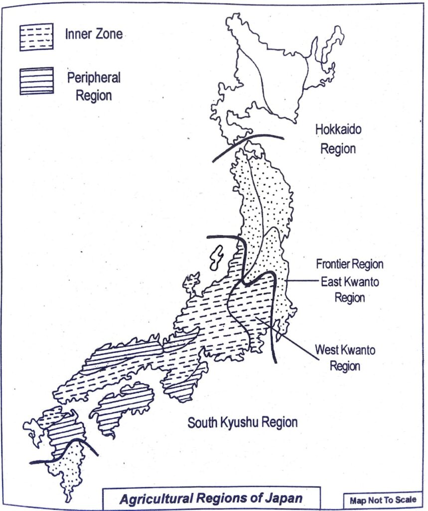
(i) Inner zone: This zone is situated in central Japan. The climate of this region is ideal for the annual cultivation of two to three crops. Due to the high density of population, the farmlands are small in size. This region is noted for the commercial cultivation of fruits, vegetables and followers.Cattle rearing is also practised in this zone. At the foothills of this region, terrace cultivation is practised.
This region is subdivided into the following divisions:
(a) Sitsi-Kinki division: This small agricultural division is included in the Sugoku hilly region. Rice is cultivated in the summer season in nearly 40% of its plains. Besides, horticulture and cattle rearing are also practised in this zone.
(b) North Kyushu division: The farming of this division is of lower quality. Abundant quality of rice is produced in the plains of this region.
(c) Sukio division: In this region, the highlands are filled
with water in artificial ways for the cultivation of rice.
(d) Tokai division: The climate here is relatively warm. Plain areas are limited in this region and so nearly 45% of the farming is confined to Highlands. This region is suitable for the production of orange and tea. Various types of vegetables are also grown here. Animal rearing is also practised in this region.
(e) West Kanto division: This region is characterised by large alluvial plains. Crops are grown twice in a year. Japan’s entire production of barley and about one-third production of wheat is done in this region.This division is well-known for mulberry trees.
(f) Tosan division: This hilly and forested division is not suitable for the cultivation of crops. Only some amount of rice is cultivated in the narrow valleys of this zone.
(g) Hakuriko division: This division is recognised as the rice producing region. The yield of rice is quite high and 45% of its rice is grown in winter.
(ii) Frontier zone: This agricultural zone comprises the southern part of Kyushu island and Tohoku. In the southern part of Kyushu island, the farmlands are very small in size and so agriculture is not much developed. Nearly 45% of the people are engaged in cultivation. The main items produced here are fruits and vegetables. Tohoku, situated in the northern part of Honshu island, has extreme cold climate and so cultivation is also not well developed here, not even during summer.
(iii) Peripheral zone: This zone comprises the highlands of southern Chikoku and the coastal areas. One of the significant features here is that jhum cultivation or shifting cultivation is practised predominantly.
This zone may be subdivided into four divisions:
(a) The central part of Kyushu.
(b) Simon.
(c) Southern part of Chikoku.
(d) Hida.Cultivation is done to a great extent in the central part of Kyushu island.
The main items cultivated here are rice, fruits, vegetables, mulberry, etc. The coastal areas of Simon are not suitable for agriculture. Jhum cultivation is mostly practised in the hilly areas of Shikoku island. Most of the areas of Hida are mountainous and so not much cultivation is done here.
[B] Hokkaido zone: This agricultural zone lies in the northern Part of Japan. The main area for cultivation in this zone is the Ichikari plain. Since this region has extreme cold weather, only one crop is cultivated during summer. The main crop of this zone is rice. Due to the nature of the topography, cold climate and infertile soil, agriculture is not much developed in this part of Japan.This agricultural zone is divided into three subdivisions- Western Hokkaido, Central Hokkaido and Eastern Hokkaido.
9. What are the chief industrial regions of Japan ? Show these regions in a map and give a brief description of each region.
Ans: Today, Japan is considered to be one of the highly industrialised nations of the world. It ranks second in industrial production in the world. In the development of science and technology, it holds the fourth position in the world. More than 40% of the national income of Japan comes from the industrial sector. More than 33% of the population of Japan is engaged in industrial activities. The industrial belt of Japan extends from Tokyo to Kyushu island-a length of about 1,000 km.
This industrial belt is subdivided into the following four industrial regions:
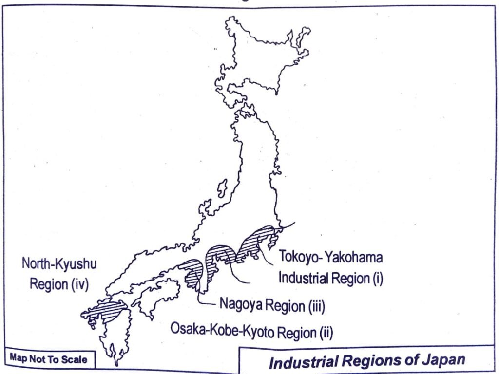
(i) Tokyo-Yakohama region: This region, situated mostly along the Tokyo Bay of the Honshu island, covers the Kanto plain. This region has ideal conditions for the industrial development. Some of the major industries that have developed here are iron and steel, shipbuilding, aircraft, chemical, textile, machinery industries, etc. This region has over 25 big and small towns. The most important among them are Tokyo and Yokohama. More than 30% of the industrial production of Japan comes from this region. Hydroelectricity is also produced here.
(ii) Osaka-Kobe-Kyoto industrial region: This industrial zone is situated in the coastal areas of Osaka Bay. It covers the Kinki plain and so this region is also known as Kinki region. The main factors that have contributed for the development of industries here are excellent water transport facilities, well-developed transport and communication system, availability of various infrastructural facilities, etc. Industries such as iron and steel, petroleum, shipbuilding, aircraft manufacturing, chemical industries, etc. are the main industries that have been developed here. The important industrial towns of this region are Osaka, Kobe and Kyoto. Osaka is noted for the production of cotton and silk.
(iii) Nagoya industrial region: This industrial zone is situated on the east coast of Honshu between Tokyo-Yokohama and Osaka-Kobe-Kyoto industrial region. This region is noted for the presence of cotton, silk and woollen textile industries. This region is also known as the ‘Detroit of Japan’ as this zone has become famous for its car manufacturing industries.
(iv) North Kyushu industrial region: This industrial region mostly lies in the northern part of Kyushu island. The main reason for the development of industries here is the availability of coal and other minerals. The chief industries developed here are iron and steel, shipbuilding, cement, tools, machine manufacturing industries, etc. Yawata, Nagasaki and Shimonosoki are the main industrial centres of this region.
10. Write short Notes on:
(a) Islands of Japan.
(b) Physiography of Hokkaido region.
(c) Industrialisation and economic development of Japan.
(d) Terrace cultivation in Japan.
(e) Tokyo Yokohama industrial region.
(f) Coastal areas of Japan.
(g) Honshu island region of Japan.
(h) Mineral resources of Japan.
Ans: (a) Islands of Japan: A series of island chains lies to the east and south-east of mainland Asia forming archipelagoes (the group of islands) in an arc shape. The islands from the tip of the Kamchatka Peninsula in the Pacific Ocean are the Kuril Islands, the Japanese Islands (Hokkaido, Honshu, Shikoku, and Kyushu), Ryukyu Islands, the Philippines, and the Indonesian Islands. The Andaman and Nicobar Islands, Sri Lanka, the Maldives, and the Lakshadweep Islands are in South Asia.
(b) Physiography of Hokkaido region: The main island hokkaido with exists in the northern most part os japan. Comprises this region the landform of this region is mountainous. This height of the Achahidak peak of the Hokkaido mountain range located in the central part of this region is 2290 metres. A Number of extensive and alluvial lowlands are found in the midst of these parallel mountain ranges. Amongst these the ishikari-Yufutoh plain formed by the Ishikari river is noteworthy. In addition Tsukushi and konsen are two other significant plains of this region Remarkably, Tsukushi plain is extensive along with terrace on the other hand the konsen plain along the coast of the pacific Ocean is formed by accumulation of marine deposits. The coastal areas being buildings, roads etc. Sapporo, Kushiro, Muroan, Asahikawa, Hakodate are small but important towns of this region.
(c) Industrialisation and economic development of Japan: Today, Japan is considered to be one of the leading industrialised nations of the world. Although she has very little resources, yet she has been able to achieve great industrial and economic progress. In terms of industrial production, Japan holds the second position and regarding development of science and technology she stands fourth. Her current per capita income is around US dollars 33,000. More than 33% of the people of Japan are engaged in the industrial sector. More than 40% of the national income comes from this sector. The factors that have contributed to her remarkable economic and industrial progress have been the hardworking spirit of the Japanese people, a very good transport and communication system, the country’s open industrial and foreign trade policies and expansion of international trade. The main industrial belt of Japan extends from Tokyo to Kyushu-a distance of more than 1,000 km. The main industries that quickened the industrial and economic progress of the country are iron and steel, cotton textile, silk textile, woollen textile, shipbuilding, paper, electrical and other manufacturing industries.
(d) Terrace cultivation in Japan: Terrace cultivation, method of growing crops on sides of hills or mountains by planting on graduated terraces built into the slope. Though labour- intensive, the method has been employed effectively to maximize arable land area in variable terrains and to reduce soil erosion and water loss.
In most systems the terrace is a low, flat ridge of earth built across the slope, with a channel for runoff water just above the ridge. Usually terraces are built on a slight grade so that the water caught in the channel moves slowly toward the terrace outlet. In areas where soils are able to take in water readily and rainfall is relatively low, level terraces may be used.
(e) Tokyo-Yokohama industrial region: This region includes the coastal areas along the Tokyo Bay of the Honshu island. This region is highly suitable for the establishment of industries as it is situated Amongst these industries the Iron and Steel industry, Ship building industry, Air craft manufacturing industry, Chemical industry, textile industry and machinery industry are notable. Besides Tokyo the megalopolis and yokohama there are more than 25 big and small towns and cities. These towns and cities are the centres of various types od industries. This zone provides to about 30% industrial production of japan moreover this region has a number of hydro electricity production centres.
(f) Coastal areas of Japan: Japan consists of four main islands and numerous small islands. Therefore, Japan has an extensive coastal area. If we look at the economy and industries of Japan, we can see that the presence of such an extensive coastal belt has greatly helped the industrial and economic development of Japan.
(i) The presence of a long coastline has helped Japan to become the leading producer of fish in the world.
(ii) The coastal regions became the centre of Japan’s international trade and business. In fact, most of the industries of Japan are situated in the coastal regions of Japan. Three of the four industrial belts, namely the Tokyo-Yokohama region, Osaka-Kobe-Kyoto region and Nagoya region are situated in the coastal regions of Japan. These regions got developed primarily because of the possibility of bringing adequate resources from outside the country as well as due to the facility for export of manufactured goods.
(g) Honshu island region of Japan: Japan consists of four main islands named Hokkaido, Honshu, Shikoku and Kyushu besides many small islands. Among these four islands the largest island is the Honshu island. Most of the Japanese population and the bulk of Japanese industries are situated in this island. The western part of this island is characterised by numerous folds and faults. Two parallel mountain ranges named Auo and Utsu lie in this island. The central part of this island has Honshu mountains and Shicito Mariana mountain ranges. The highest portion of this mountain system is known as Hida mountain. Mount Fuji, the holy mountain of the Japanese, is situated in this island. Kwanto plain and Nabi plain are two important plains of this region. River Tone is an important river of this island. Most of the major cities of Japan such as Tokyo, Yakohama, Nagoya, Toyama, Aomori, Akita, Morioka, Hachinohe, Sendai, Koriyama, Yamaguta, etc. are situated in this island.
(h) Mineral resources of Japan: Japan has limited mineral resources. Coal reserves are neither of high grade nor sufficient for the country’s requirement. Japan is also poor in iron ore deposits. However, there are valuable copper deposits and fairly good deposits of sulphur in Japan. Therefore, she has to import most of the essential minerals required for the industrial development of the country. Japan is particularly deficient in iron ore and petroleum. Therefore, she has to depend very much on import of these two essential items. However, Japan is very rich in water power. Heavy rainfall, swift flowing streams and the rugged relief conditions have given her great facilities for the development of hydroelectric power.

Hi, I’m Dev Kirtonia, Founder & CEO of Dev Library. A website that provides all SCERT, NCERT 3 to 12, and BA, B.com, B.Sc, and Computer Science with Post Graduate Notes & Suggestions, Novel, eBooks, Biography, Quotes, Study Materials, and more.


Good