
NCERT Class 9 Social Science Chapter 10 Oceans and Life Solutions English Medium As Per New Syllabus. NCERT Class 9 Social Science Chapter 10 Oceans and Life Notes to each chapter is provided in the list so that you can easily browse throughout different chapter NCERT Class 9 Social Science Chapter 10 Oceans and Life Question Answer Download PDF and select needs one.
NCERT Class 9 Social Science Chapter 10 Oceans and Life
Also, you can read the CBSE book online in these sections Solutions by Expert Teachers as per (CBSE) Book guidelines. NCERT Class 9 Social Science Textual Solutions. These solutions are part of NCERT All Subject Solutions. Here we have given NCERT Class 9 Social Science Notes in English Medium Solutions for All Subject, You can practice these here.
Oceans and Life
Chapter – 10
| Part – II: Understanding Society India and Beyond |
| Textual Question Answer |
1. What is the importance of ocean relief?
Ans: Ocean relief is important because it influences marine life, the availability of ocean resources, and human activities such as fishing, transportation, and underwater exploration.
2. How does ocean water movement impact life and environment?
Ans: Ocean water movements, such as waves, tides, and currents, shape the Earth’s surface, support marine life, influence climate, and help in fishing and transportation. They also affect coastal environments.
3. Why are maritime zones important for a country?
Ans: Maritime zones are important because they define a country’s rights over ocean resources, such as fish, oil, and natural gas. They also help regulate navigation, protect marine resources, and maintain security and peaceful relations between countries.
4. How can we use ocean resources in a sustainable way?
Ans: Oceans hold extensive living resources(like fish, seafood, aquatic vegetation) and non-living resources(minerals, oil, gas, wave/tidal energy). Using these sustainably requires adopting the Blue Economy framework and UN Sustainable Development Goal 14.
Preventing Ocean Degradation: Enforcing rules to reduce marine pollution and ocean acidification, alongside strict compliance with international regulations like MARPOL to eliminate ship-sourced pollution.
Regulating Fisheries: Setting fishing quotas, eliminating harmful fishing subsidies, and conserving sensitive marine protected areas to allow fish stocks to replenish.
Transitioning to Clean Energy: Developing offshore renewable “blue energy” sources—such as tidal, wave, current, and offshore wind energy—to meet power needs without damaging marine ecosystems.
Global Legal Compliance: Following established international maritime laws to prevent overexploitation of the high seas.
5. How do early warning systems help protect people from tsunamis and cyclones?
Ans: Early Warning Systems operate as real-time alarm and monitoring networks designed to detect ocean hazards early, forecast impact, and broadcast timely evacuations:
Tsunami Warning Networks:
Real-time Detection: Undersea earthquakes are identified by seismic stations.
Seafloor and Wave Tracking: Ocean Bottom Pressure Recorders (OBPRs) on the seafloor confirm the passage of tsunami waves, while real-time tsunami detection buoys, coastal tide gauges, and radar systems track wave movement and sea level changes.
Cyclone and Storm Surge Prediction:
Satellite and Atmospheric Tracking: Satellites detect atmospheric disturbances over warm waters to track cyclone paths and intensity.
Surge Forecasts: Centers like INCOIS and IMD use systems like the Storm Surge Early Warning System (SSEWS) to predict cyclone-induced flooding extent and coordinate response via initiatives like the National Cyclone Risk Mitigation Project (NCRMP).
Rapid Alert Dissemination and Local Technology:
Alerts are transmitted via satellite networks, SMS, email, and display boards to government agencies and coastal communities.
Specialized tools like GEMINI, a handheld satellite receiver device broadcast real-time weather alerts, wave heights, and disaster warnings directly to fishermen’s mobile phones in regional languages.
Questions and activities
1. How do different features of the ocean floor affect human activities such as fishing, transport, and underwater exploration?
Ans: Submarine relief consists of diverse physical landforms beneath the sea that directly shape human maritime activities:
Continental Shelf: This shallow, submerged margin extending from continents (0–200 m depth) receives sunlight, making it rich in coastal/neritic fish and marine biodiversity. It serves as a primary site for commercial fishing, as well as offshore oil, natural gas, sand, and mineral extraction.
Continental Slope and Abyssal Plains: The steep continental slope leads down to vast, flat abyssal plains. Abyssal plains form the deep ocean floor where submarine communication cables are laid across international waters to connect global communications.
Underwater Features: Underwater volcanic mountains, deep ocean trenches (such as the Mariana Trench), and mid-ocean ridges form a complex underwater topography (bathymetry). Studying bathymetry is essential for deep-sea navigation, sub-surface exploration, and mapping oceanic ecosystems. Shallow channels over bathymetric features require large vessels (like VLCCs) to carefully time their transit during high tides to avoid running aground.
2. How do waves, tides, and ocean currents influence climate, marine life, and human activities around the world?
Ans: Waves, tides, and ocean currents influence climate, marine life, and human activities in several ways. Waves shape coastlines through erosion and deposition, forming features such as beaches, sea caves, and arches. Tides help ships enter and leave harbours safely, support fishing activities, and can be used to generate electricity. Ocean currents influence the climate of coastal regions by carrying warm or cold water from one place to another. They also support marine life by creating rich fishing grounds where warm and cold currents meet. These ocean movements are important for fishing, navigation, transportation, and maintaining the balance of marine ecosystems.
3. Describe the importance of marine resources.
Ans: Marine resources are very important for human life, economic development, and environmental balance. Oceans provide food, such as fish and seafood, which are rich in protein. They provide employment and livelihoods to millions of people through fishing, aquaculture, trade, and tourism. Oceans are also sources of valuable resources such as oil, natural gas, minerals, sand, and gravel. In addition, they offer renewable energy through tides, waves, and ocean currents. Marine ecosystems support biodiversity and provide habitats for numerous plants and animals. Therefore, marine resources must be used sustainably to protect ocean ecosystems and ensure their availability for future generations.
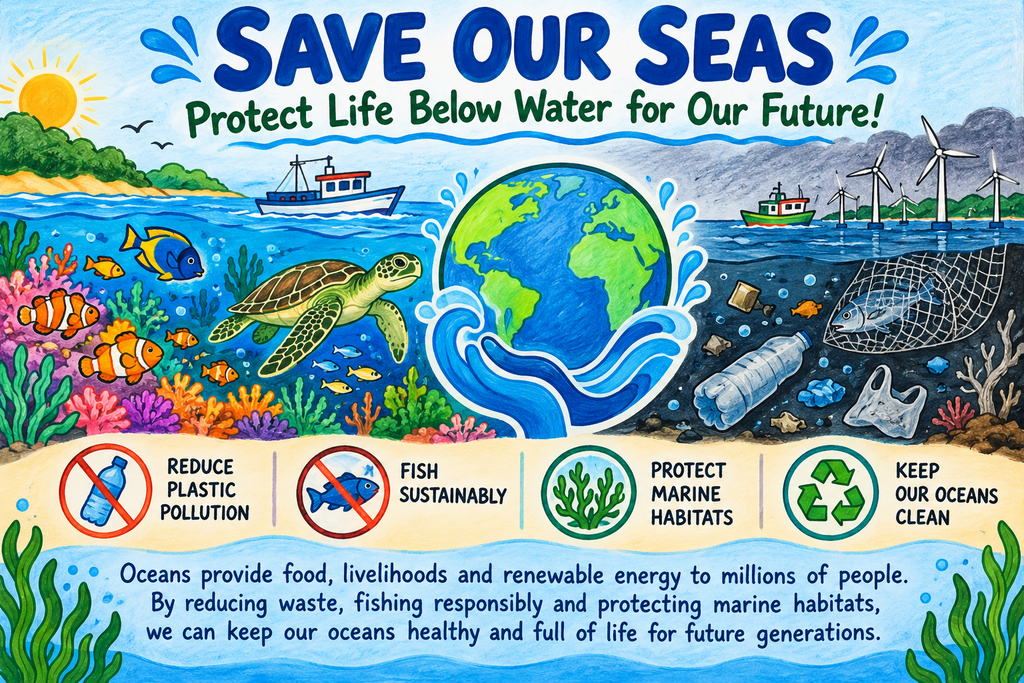
4. Draw a poster that encourages people to protect marine resources. Include a slogan (like Save Our Seas or Fish for the Future) and explain your message in 2-3 sentences.
Ans:
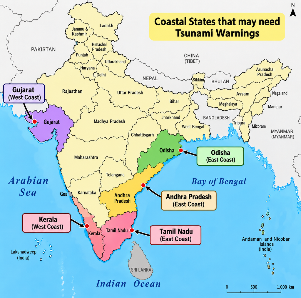
5. Using a map of India, mark at least five coastal states that might need tsunami warnings.
Ans:
6. Work in a group and act out what would happen when a cyclone na cyclone warning is issued. Highlight what role different people, like scientists, officials, and coastal villagers, would play.
Ans: Narrator: One day, scientists observe a powerful cyclone approaching the coastal area. They issue a cyclone warning to protect people’s lives.
Scientist: “A severe cyclone is approaching the coast. It may bring strong winds, heavy rainfall, and flooding. We must inform the authorities immediately.”
Government Official: “We have received the warning. Everyone in the coastal villages must move to safer places. We will open relief camps and arrange food, drinking water, and medicines.”
Police Officer: “All villagers must evacuate the low-lying areas. Please follow the instructions and do not go near the sea.”
Fisherman: “We will immediately bring our boats back to the shore and stop going out to sea.”
Coastal Villager: “We will secure our homes, carry essential belongings, and move to the cyclone shelter with our children and elderly family members.”
Rescue Worker: “We are ready to help people who need assistance. We will rescue those trapped by floodwater and provide first aid.”
Narrator: The cyclone hits the coast, causing heavy rain and strong winds. Everyone follows safety instructions and stays in shelters until the danger passes.
Government Official: “The cyclone has weakened. Rescue teams will inspect the affected areas and provide relief to the people.”
Coastal Villager: “Thank you to the scientists, officials, police, and rescue workers for helping us stay safe.”
Narrator: In this way, scientists provide early warnings, officials coordinate evacuation and relief, police maintain safety, fishermen follow warnings, villagers cooperate, and rescue workers save lives.
All Together: “Early warning, proper planning, and cooperation can save lives during a cyclone!”
7. Suppose a foreign ship is sailing through India’s territorial sea. What principle allows the ship to pass through rough these t waters, subject to certain conditions?
Ans: Applicable Principle: Innocent Passage.
Conditions and Rules: Under international maritime law (UNCLOS), foreign ships are granted the right of innocent passage through a country’s Territorial Sea (extending up to 12 nautical miles from the baseline).
Key Constraints:
The passage must be continuous and expeditious without stopping, except in cases of force majeure, breakdown, or distress.
The vessel must not engage in activities that threaten the peace, good order, or security of the coastal state (like weapons testing, military operations, illegal fishing, espionage, or deliberate marine pollution).
8. A country has an Exclusive Economic Zone (EEZ) extending up to 200 nautical miles from its baseline. What rights does the country have over the natural resources in this zone?
Ans: Under UNCLOS, an Exclusive Economic Zone (EEZ) extends from the baseline up to 200 nautical miles:
Resource Rights: The coastal nation holds sole sovereign rights to explore, harvest, manage, and conserve all natural living resources (such as coastal and deep-water fish) and non-living resources (such as seabed minerals, petroleum, natural gas, and gas hydrates).
Energy Rights: The country has the exclusive right to harness renewable energy from ocean currents, waves, tides, and offshore wind.
Jurisdiction Limits: The country does not possess full territorial sovereignty over the water surface itself. Foreign ships and aircraft retain the right of peaceful navigation and overflight through the EEZ, as well as the freedom to lay submarine cables and pipelines.
9. Create a model of an ocean with ship routes, protected zones, and safety measures. Based on the model, explain how it follows maritime laws and protects the ocean.
Ans: Model Description and Features:
(i) Ship Routes: Designated shipping lanes with marked traffic flow directions, clear give-way rules, navigation lights, and speed buffers to prevent ship collisions in heavy traffic areas.
(ii) Marine Protected Areas: Designated eco-zones off-limits to heavy commercial traffic, seabed mining, and intensive fishing to preserve coral reefs and endangered marine life.
(iii) Safety and Hazard Systems: Real-time Tsunami Detection Buoys (OBPRs) connected to satellites, tide stations, and GEMINI coastal transmitters for alerting vessels to high waves or seismic activity.
(iv) Waste and Pollution Checks: Onboard compliance monitoring for vessel emissions and discharge.
Alignment with Maritime Laws and Conservation:
(i) Prevents Accidents: By establishing clear “rules of the road,” proper lookout signals, and safe vessel passing corridors, the model minimizes collisions and hazardous spills.
(ii) Protects the Environment: Enforcing MARPOL pollution standards ensures ships cannot dump oil or waste, reducing marine degradation and protecting ecosystem health.
(iii) Respects Maritime Boundaries: Clearly separates territorial waters (12 NM), contiguous zones (24 NM), EEZs (200 NM), and international high seas, ensuring fair resource usage without territorial disputes.
Subject Ka Complete Video Solution Dekhein
Step-by-step easy concept explanation aur full questions Answer ke liye watch karein ya app download karein:

 Buy Now