NCERT Class 9 Social Science Chapter 8 Physical Features Of India Solutions to each chapter is provided in the list so that you can easily browse through different chapters NCERT Class 9 Social Science Chapter 8 Physical Features Of India and select need one. NCERT Class 9 Social Science Chapter 8 Physical Features Of India Question Answers Download PDF. NCERT SST Class 9 Solutions.
NCERT Class 9 Social Science Chapter 8 Physical Features Of India


Also, you can read the NCERT book online in these sections Solutions by Expert Teachers as per Central Board of Secondary Education (CBSE) Book guidelines. CBSE Class 9 Social Science Solutions are part of All Subject Solutions. Here we have given NCERT Class 9 Social Science Chapter 8 Physical Features Of India and After, NCERT Class 9 Social Science Textbook of India and The Contemporary World – I: History, Contemporary India -I: Geography, Democratic Politics – I: Political Science, Economics and Disaster Management. for All Chapters, You can practice these here.
Physical Features Of India
Chapter: 8
CONTEMPORARY INDIA – I (GEOGRAPHY)
NCERT TEXTBOOK QUESTIONS WITH ANSWERS
Q. 1. Choose the right answer from the following:
1. A landmass bounded by sea on three sides is referred as:
(a) Peninsula.
(b) Island.
(c) Coast.
(d) None of them.
Ans (a)Peninsula.
2. Mountain ranges in the eastern part of India forming its boundary with Myanmar are collectively called:
(a) Himachal.
(b) Uttranchal.
(c) Purvanchal.
(d) None of them.
Ans (c) Purvanchal.
3. The western coastal strip south of Goa is referred to as:
(a) Coromandal.
(b) Konkan.
(c) Kannad.
(d) Northern.
Ans. (b) Konkan.
4. The highest peak in Eastern Ghats is:
(a) Anamudi.
(b) Kanchenjunga.
(c) Mahendragiri.
(d) Khasi.
Ans. (c) Mahendragiri.
Q. 2. Answer the following questions briefly:
(i) What are tectonic plates?
Ans. As per the theory of Plate Tectonics, large short of rocks in the earth’s mantle are called tectonic plates. These largo sheets of rocks make the earth’s surface and move slowly. There are some major and some minor plates which have combinedly formed the crust (upper part) of the earth.
(b) Which continents of today were part of the Gondwana land?
Ans. These were:
(i) India (Subcontinent).
(ii) Australia.
(iii) South Africa. and
(iv) South America.
(iii) What is the bhabar?
Ans. A narrow belt of land measuring 8 to 16 km. in width has been formed at the slopes of the Shivalike. It is parallel to Shivalik and leveled plain land. This bhabar has been formed of pebbles brought by the rivers flowing down from mountains.
(iv) Name the three major divisions of the Himalaya from north to south.
Ans. These are The Greater Himalayas, The Lesser Himalayas and The Shivalik or Outer Himalayas.
(v) Which plateau lies between the Aravali and the Vindhya ranges.
Ans. It is Malwa plateau.
(vi) Name the island group of India having coral origin.
Ans. Small group of islands known as Larcadive, Minicoy and Amindivi but renamed in 1973 as Lakshadweep.
Q. 3. Distinguish between
(i) Converging and diverging tectonic plates.
Ans. Distinction between Converging and Diverging Plates:
| Converging Plates | Diverging Plates |
| 1. These plates are moved to each other by the force of convectional currents. | 1. These plates regress to and back side of them viz. more reverse to each other thus, create a gap even increasing. |
| 2. These determine the converging limitations. | 2. These determine the diverging limitations. |
| 3. As a result of moving towards each other, either these collide or slide viz. plate slips under the other. | 3. As a result of adverse motion, these plates create void between them immediately filled with water body. |
(ii) Bhangar and Khadar.
Ans. Contrast between Bhangar and Khadar:
| Bhangar | Khadar |
| 1. These are low plains with old alluvial soil mixed with pebbles. | 1. The deposits of alluvium fresh every year brought by the Himalayan rivers maken this belt of northern plains. |
| 2. This belt falls at higher elevation of the flood-plin. | 2.This belt is actually lower flood plains. |
| 3. This belt ends in Khadar. | 3. This belt of northern plains ends in Tarai. |
| 4. It is less fertile. | 4. It is more fertile. |
(iii) Western Ghats and Eastern Ghats.
Ans. Distinction between Eastern and Western Ghats:
| Eastern Ghats | Western Ghats |
| 1. These are situated at the east to Deccan plateau. | 1. These are on reverse side of Eastern Ghats i.e. West to Deccan Plateau. |
| 2. These are parallel to eastern coast i.e. Curmandal, Northern Circar, etc. | 2. These are parallel to western coastal i.e. konkan, kannad, Malabar etc. |
| 3. Northern Circar (between Mahanadi and Krishna rivers) and Coromandel (between Krishna and Kavari rivers) are the coastal plains here. | 3. Konkan ( Mumbai to Goa), Kannel (Goa to Kerala) and Malabar (Kerala to Kanyakumari) are the coastal plains here. |
| 4. Mahanadi, Godavari, Krishna, Kaveri, etc. rivers drawn this landform. | 4. Narmada, Tapi, Sabarmati and Mahi rivers drawn this land. |
| 5. Mahendragiri with an altitude of 1501 metres is the highest peak here. | 5. Anamudi with an altitude of 2695 meters is the highest peak here. |
| 6. These consist of eastern coastal plains. | 6. These constitute western coastal plains. |
Q. 4. Describe how the Himalayas were formed.
Ans. Formation of the Himalayas:
(i) About 200 million years ago, a single giant landmass called the Pangea break into two parts-
(a) Lauresin (northern part). and
(b) Gondwanaland (southern part).
(ii) Later, convectional currents broker or fractured the crust of Gondwanaland into a number of plates.
(iii) One of the broken plates called Indo-Australian plate drifted towards the north and collided with much larger Eurasian plateau.
(iv) Due to this collision, the sedimentary rocks which were accumulated in the geosyncline known as Tethys were folded and uplifted to form the mountain system of western Asia and Himalayas.
Q. 5. Which are the major physiographic divisions of India? Contrast the relief of the Himalayan region with that of the Peninsular plateau.
Ans. These are:
(i) The Himalayan Mountain.
(ii) The Northern Plains.
(iii) The Peninsular Plateau.
(iv) The Indian Desert.
(v) The Coastal Plains. And
(iv) The Islands.
Contrast between Himalayan region with the Penitimilar Plateau:
| The Himalayas | The Peninsular Plateau |
| 1. These are young fold mountains. | 1. It has rounded hills because of oldest landmass. |
| 2. Himalayas have three fold ranges i.e. (a) The Greater Himalayas. (b) The Middle Himalayas. and (c) The Outer Himalayas. | 2. It has two divisions i.e. (a) Central Highlands. (b) Deccan plateau. |
| 3. Himalayas are formed by metamorphic rocks granite core, compressed and altered rocks and unconsolidated sediments. | 3. Peninsular plateau is composed of the old crystalline igneous and metamorphic rocks. |
| 4. The Ganga, the Brahmaputra and the Indus and their tributaries rise from Himalayas. | 4. This plateau is drained by the Chambal, the Sind, the Betwa and the Ken rivers. |
| 5. Dhauladhar, Mahabharat, Pir Panjal, Naga hills, Mizo hills, Patkai Bum, Jaintia, the Khasi and the Garo hills and mountain ranges are found here. | 5. Vindhyan, Satpura, Mahadev, Maikal, Kaimur hills and mountain ranges including Malwa plateau, Bundelkhand, Baghelkhand, Chota Nagpur plateau are located here. |
| 6. Glaciers and passes are seen in Himalayas. | 6. Being tableland, landforms of that type are not seen here. |
Q. 6. Give an account of the Northern Plains of India.
Ans. The Northern Plains of India: These were formerly a part of Tethys sea i.e. depressed land filled with water. This low land gradually filled with sediments brought by perennial rivers of the Himalayan region as also the mud, silt and pebbles shed by Gondwana and Angara land. During the internal motions of the earth, these drifted towards north of the peninsular plateau and the Tethys sea started folding. The stock of sediments thus, began folding and got elevation. The highest elevation is thus known as the Himalaya Mountains and plain but higher than sea level landform, we say, the Northern Indian Plains, consisting of Ganga-Yamuna Doab, Ganga-Brahmaputra Delta and Indus plains.
Q. 7. Write short notes on the following:
(i) The Indian Desert.
Ans. The Indian Desert: This landform is undulating sandy plain covered with sand dunes. This area lies towards the western margins of the Aravali Hills. It receives scanty rainfall of 15 cm. yearly thus, not habitable. It is arid land and without vegetation cover. Luni is only river, we see here and that too is categorized as inland drainage.
(ii) The Central Highlands.
Ans. The Central Highlands: The Central Highlands extend at north to Narmada and cover a major area of the Malwa Plateau. Vindhya and Aravallis give it boundary at south and north respectively. Chambal, Sind, Betwa and Ken rivers drawn this landform southwest to northeast. These are wider in the west than at the east. Bundeldkhand, Baghelkhand, Chota Nagpur plateau are at its eastward extension. The Deccan Plateau is separated by Narmada and lies at the south of this region.
(iii) The Island groups of India.
Ans. The Island groups of India: The two groups of island at west and eastern south of India are:
(i) Andaman and Nicobar Islands. and
(ii) Lakshadweep Islands.
Andaman and Nicobar islands consist of more than three hundred islands. These are at about 1200 km. away from the mainland. Andaman and Nicobar islands are actually the ridges immersed into the sea. These are significant for defense purposes. Nicobar islands are at the south of Andaman islands. India’s only active volcano exists in Barren island here. Headquarter of this U.T. falls at Port Blair. Indira Point i.e. the southernmost point of India also was here.
Lakshadweep consists of thirty islands is in Arabian sea. Total area of this group is 32 sq. km. Headquarter of Lakshadweep exists at Kavaratti island. A bird sanctuary is settled at Pitli island. Lakshadweep is formed of atolls. These were known as Laccadive, Minicoy and Amindivi.
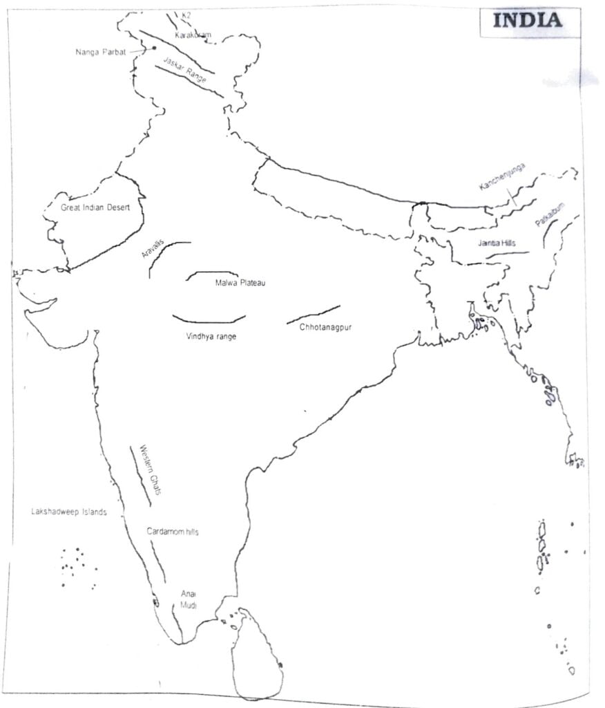
MAP SKILLS
On an outline map of India show the following:
(i) Mountain and hill ranges-the Karakoram, the Zaskar the Pathai Bum, the Jaintia, the Vindhya range, the Aravali and the Cardamom hills.
(ii) Peaks-K2, Kanchenjunga, Nanga Parbat and the Anaimudi.
(iii) Plateaus-Chotanagpur and Malwu.
(iv) The Indian Desert, Western Ghats, Lakshadweep Islands.
Ans.
PROJECT ACTIVITY
Late the peaks, passes, ranges, plateaus, hills, and duns hidden in the puzzle. Try to find where these features are located. You may start your search Jewisontally, vertically and diagonally.
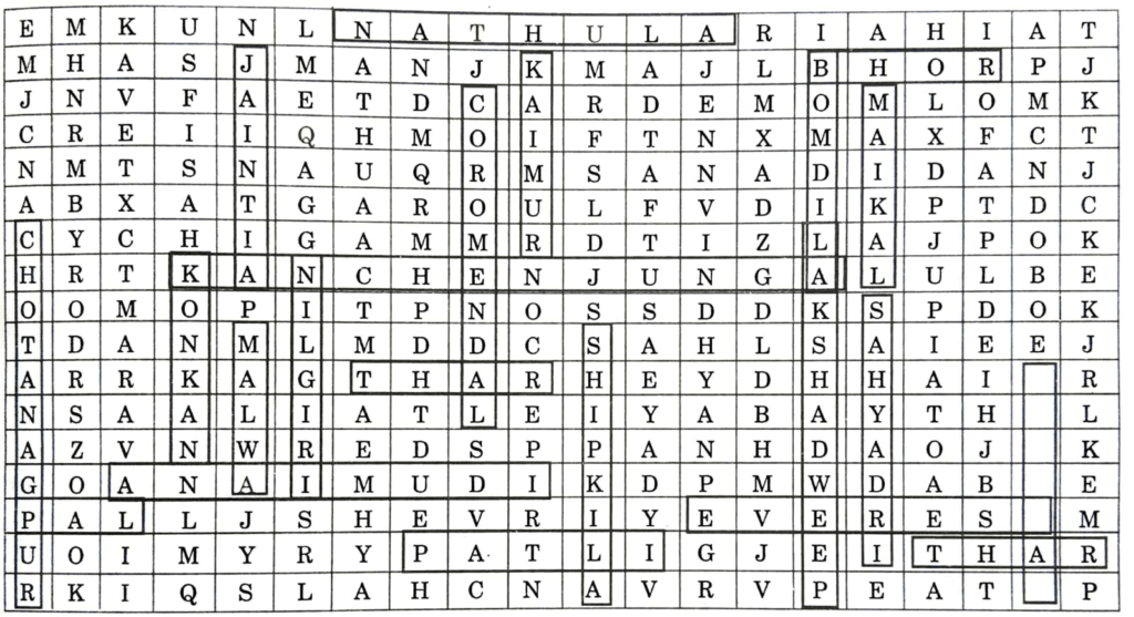
Ans. Passes: Nathula, Bomdila, Shipki La.
Ghats: Bhor Ghat, Pal Ghat.
Hills: Garo, Khani, Jaintia.
Peaks: Everest, Kanchenjunga, Anai Mudi.
Mountain Ranges: Vindhya, Maikal, Sahyadri.
Dweep: Lakshadweep.
Plateau: Chottanagpur, Malwa.
SOME OTHER IMPORTANT QUESTIONS FOR EXAMINATION
MULTIPLE CHOICE QUESTIONS
Q. 1. The northern most range of the Himalayas is known as:
(a) Himadri.
(b) lesser Himalaya.
(c) Shivalik.
(d) none of the above.
Ans. (a) Himadri.
Q. 2. The Kangra and Kullu valley are located in:
(a) Uttarakhand.
(b) Jammu and Kashmir.
(c) Himachal Pradesh.
(d) Uttar Pradesh.
Ans. (c) Himachal Pradesh.
Q. 3. Majuli is a riverine island located in the river:
(a) Ganga.
(b) Brahmaputra.
(c) Yamuna.
(d) Kaveri.
Ans. (d) Kaveri.
Q. 4. Dudhwa National Park is located in the state of:
(a) Assam.
(b) Uttar Pradesh.
(c) Madhya Pradesh.
(d) Rajasthan.
Ans. (b) Uttar Pradesh.
Q. 5. The soil containing calcareous deposits is locally known as:
(a) Bhangar.
(b) Khadar.
(c) Bhabar.
(d) Kankar.
Ans. (d) Kankar.
Q. 6. The highest peak in the Eastern Ghats is:
(a) Anai Mudi.
(b) Doda Betta.
(c) Ooty.
(d) Mahendragiri.
Ans. (d) Mahendragiri.
Q. 7. Jaisalmer is in:
(a) Himachal Pradesh.
(b) Rajasthan.
(c) Gujarat.
(d) Uttar Pradesh.
Ans. (b) Rajasthan.
Q. 8. Barchans are found in:
(a) desert regions.
(b) plains.
(c) Plateaus.
(d) hilly regions.
Ans. (a) desert region.
Q. 9. The northern part of the western coast is called the:
(a) Konkan.
(b) Kannad plain.
(c) Malabar conant.
(d) Coromandel coast.
Ans. (a) Konkan.
Q. 10. Lake Chilika lies in the state of:
(a) Jharkhand.
(b) Telangana.
(c) Odisha.
(d) Tamil Nadu.
Ans. (c) Odisha.
Q. 11. A landmass bounded by sea on three sides is referred to as:
(a) Coast.
(b) Island.
(c) Peninsula.
(d) None of the above.
Ans. (c) Peninsula.
Q. 12. Mountain ranges in the eastern part of India forming its boundary with Myanmar are collectively called as:
(a) Himachal.
(b) Uttarakhand.
(c) Purvanchal.
(d) None of the above.
Ans. (c) Purvanchal.
Q. 13. The western coastal strip, south of Goa is referred to as:
(a) Coromandel.
(b) Konkan.
(c) Kannad.
(d) Northern Circar.
Ans. (c) Kannad.
Q. 14. The highest peak in the Eastern Ghats is:
(a) Antai Mudi.
(b) Kanchenjunga.
(c) Malandragiri.
(d) Khasi.
Ans. (c) Mahendragiri.
Q. 15. A narrow gap in a mountain range providing access to the other side is:
(a) Mound.
(b) Pass.
(c) Strait.
(d) Valley.
Ans. (b) Pass.
Q. 16. Which two hills are located in the south-east of Eastern Ghats?
(a) Mizo Hills and Naga Hills.
(b) Javadi Hills and Shevaroy Hills.
(c) Patkot Hills and Manipuri Hills.
(d) Mizo Hills and Patkoi Hills.
Ana. (b) Javadi Hills and Shevaroy Hills.
Q. 17. The longitudinal valleys lying between lesser Himalayas and Shivaliks are known as:
(a) Kangra Valley.
(b) Patkai Bum.
(c) Passes.
(d) Duns.
Ans. (d) Duns.
Q.18. In which division of the Himalayas are the famous valleys of Kashmir, Kangra and Kullu located?
(a) The Himadri.
(b) The Himachal.
(c) The Shivaliks.
(d) The Duns.
Ans. (b) The Himachal.
Q. 19. What are Lesser Himalayas known as?
(a) Himadri.
(b) Himachal.
(c) Shivalika.
(d) Purvanchal.
Ans. (b) Himachal.
Q. 20. Which of the following is the highest peak in India?
(a) Mt. Everest.
(b) Kanchenjunga.
(c) Nanga Parbat.
(d) Nanda Devi.
Ans. (b) Kanchenjunga.
Q. 21. The Himalayas consist of three parallel ranges in its longitudinal extent. Which of the following is the name of the northern-most range?
(a) The Himadri.
(b) The Himachal.
(c) The Shivaliks.
(d) The Purvanchal.
Ans. (a) The Himadri.
Q. 22. Which of the following are young-fold mountains?
(a) The Aravallis.
(b) The Nilgiris.
(c) The Himalayas.
(d) The Sahyadri.
Ans. (c) The Himalayas.
Q. 23. Geologically, which of the following physiographic divisions of India is supposed to be one of the most stable land blocks?
(a) The Himalayas.
(b) The Northern Plains.
(c) The Peninsular Plateau.
(d) The Indian Desert.
Ans. (c) The Peninsular Plateau.
Q. 24. Which of the following physiographic divisions of India was formed out of accumulations in the Tethys geosynclines?
(a) The Himalayas.
(b) The Northern Plains.
(c) The Peninsular Plateau.
(d) The Indian Desert.
Ans. (a) The Himalayas.
Q. 25. Which of the following countries or continents was not a part of the ancient landmass of Gondwanaland?
(a) India.
(b) Australia.
(c) Europe.
(d) South America.
Ans. (c) Europe.
Q. 26. Which of the following divisions of India has the oldest landmass?
(a) The Himalayas.
(b) The Northern Plains.
(c) The Peninsular Plateau.
(d) The Indian Desert.
Ans. (c) The Peninsular Plateau.
Q. 27. According to the ‘Theory of Plate Tectonics,’ what have been the effects of the movement of the plates?
(a) Change in position and size of continents.
(b) Formation of ocean basins.
(c) Evolution of the present landforms and relief of India.
(d) All of the above.
Ans. (d) All of the above.
Q. 28. According to the ‘Theory of Plate Tectonics,’ when some plates move away from each other, which of the following is formed?
(a) Convergent boundary.
(b) Divergent boundary.
(c) Transform boundary.
(d) None of the above.
Ans. (b) Divergent boundary.
Q. 29. According to the ‘Theory of Plate Tectonics,’ the movement of the plates results in some geological activity. Which one of the following is not such a geological activity?
(a) Volcanic activity.
(b) Folding.
(c) Faulting.
(d) Glaciation.
Ans. (d) Glaciation.
Q. 30. Which of the following is a plausible theory presented by Earth scientists to explain the formation of continents and oceans and the various landforms?
(a) Theory of Motion.
(b) Theory of Plate Tectonics.
(c) Theory of Evolution.
(d) Theory of Relativity.
Ans. (b) Theory of Plate Tectonics.
Q. 31. Which of the following is responsible for the variation in the colour of soil in different parts of India?
(a) Difference in rock formations.
(b) Weathering.
(c) Erosion and deposition.
(d) Land use.
Ans. (a) Difference in rock formations.
Q. 32. In the question given below, there are two statements marked as Assertion (A) and Reason (R). Read the statements and chose the correct option.
Assertion (A): The folds of the Great Himalayas are symmetrical in nature.
Reason (R): It is perennially snow bound, and a number of glaciers descend from this range.
Options:
(a) (A) is correct but (R) is wrong.
(b) (A) is wrong but (R) is correct.
(c) Both (A) and (R) are true but (R) is not the correct explanation of (A).
(d) Both (A) and (R) are true and (R) is the correct explanation of (A).
Ans. (b) (A) is wrong but (R) is correct.
Q. 33. In the question given below, there are two statements marked as Assertion (A) and Reason (R). Read the statements and chose the correct option.
Assertion (A): The range lying to the south of the Himachal forms the most rugged mountain system.
Reason (R): The ranges are mainly composed of high alluvium deposits.
Options:
(a) (A) is wrong but (R) is correct.
(b) (A) is correct but (R) is wrong.
(c) Both (A) and (R) are wrong.
(d) Both (A) and (R) are true but (R) is not the correct explanation of (A).
Ans. (c) Both (A) and (R) are wrong.
Q. 34. In the question given below, there are two statements marked as Assertion (A) and Reason (R). Read the statements and chose the correct option.
Assertion (A): The Shivaliks are covered with thick gravel and alluvium.
Reason (R): The ranges are mainly composed of highly compressed and altered rocks.
Options:
(a) (A) is correct but (R) is wrong.
(b) (A) is wrong but (R) is correct.
(c) Both (A) and (R) are true and (R) is the correct explanation of (A).
(d) Both (A) and (R) are true but (R) is not the correct explanation of (A).
Ans. (d) Both (A) and (R) are true but (R) is not the correct explanation of (A).
Q. 35. In the question given below, there are two statements marked as Assertion (A) and Reason (R). Read the statements and chose the correct option.
Assertion (A): The rivers coming from northern mountains are involved in depositional work.
Reason (R): Due to gentle slope, the velocity of the river increases, which results in the formation of riverine islands.
Options:
(a) (A) is correct but (R) is wrong.
(b) (A) is wrong but (R) is correct.
(c) Both (A) and (R) are true and (R) is the correct explanation of (A).
(d) Both (A) and (R) are true but (R) is not the correct explanation of (A).
Ans. (a) (A) is correct but (R) is wrong.
Q. 36. In the question given below, there are two statements marked as Assertion (A) and Reason (R). Read the statements and chose the correct option.
Assertion (A): One of the distinct features of the Peninsular plateau is the black soil area known as Deccan Trap.
Reason (R): This is because the plateau is of volcanic origin.
Options:
(a) (A) is correct but (R) is wrong.
(b) (A) is wrong but (R) is correct.
(c) Both (A) and (R) are true and (R) is the correct explanation of (A).
(d) Both (A) and (R) are true but (R) is not the correct explanation of (A).
Ans. (c) Both (A) and (R) are true and (R) is the correct explanation of (A).
Fill in the Blanks:
(i) The ‘Mount Everest’ lies in __________.
Ans. Nepal.
(ii) Slow moving rivers of snow are known as __________.
Ans. glaciers.
(iii) The _________ are the flat low-lying lands.
Ans. alluvial plains.
(iv) __________ is separated from the sea by a the reef or by an area of rock or sand.
Ans. Lagoon.
(v) The crust of the earth is made up of sever __________.
Ans. tectonic plates.
True and False:
(i) The large fragments of the crust are called tectonic or lithospheric plates.
Ans. True.
(ii) A high area of rock with a very steep side is known as bluff.
Ans. False.
(iii) A Dun is a narrow longitudinal valley lying in between the Shiwaliks and the Lesser Himalayas.
Ans. True.
(iv) A distributary is a river or rivulet that merges itself with the main river.
Ans. False.
(v) The south-western part of the Himalayas is known as the Kashmir Himalayas.
Ans. False.
VERY SHORT ANSWER TYPE QUESTIONS
Q. 1. The Northern Plains has been formed by the interplay of three major river systems. Name them.
Ans. The Indus-Ganga-Brahmaputra.
Q. 2. Name the western and the eastern edges of the Deccan Plateau.
Ans. The Western Ghats and the Eastern Ghats.
Q. 3. Name the mountain ranges located in the eastern part of India.
Ans. Purvanchal or the eastern hill and mountain.
Q. 4. What are ‘Duns’?
Ans. The valleys lying between Lesser Himalayas and the Shiwaliks are known as the Duns.
Q. 5. According to the ‘Theory of Plate Tectonics,’ what are the effects of the movement of the plates?
Ans. Change in position and size of continents, and formation of ocean basins.
Q. 6. What are barchans?
Ans. Barchans are crescent-shaped dunes found in the Indian desert.
Q. 7. Which is the highest peak in India?
Ans. Kanchenjunga
Q. 8. Which two hills are in the Southeast of the Eastern Ghats?
Ans. Javadi Hills and Shevaroy Hills.
Q. 9. What do we mean by the term ‘Bhangar’?
Ans. Bhangar is the older alluvial soil region lying above the floodplains and presenting a terrace like feature.
Q. 10. What is the name of the part of the Himalayas lying between the Kali and the Teesta rivers?
Ans. The part of the Himalayas lying between the Kali and the Teesta rivers is called Nepal Himalayas.
Q. 11. The state of Meghalaya forms a part of which physiographic division of India?
Ans. Meghalaya is a part of the eastern Extension of the Peninsular Plateau.
Q. 12. What do you understand by the term “peninsula”?
Ans. Peninsula is a landmass that is bounded by sea on three sides.
Q. 13. Name the Indian state where Kanchenjunga is located.
Ans. Kanchenjunga is located in Sikkim.
Q. 14. What is the Peninsular Plateau composed of?
Ans. The Peninsular Plateau is composed of igneous and metamorphic rocks.
Q. 15. Which is the largest inhabited riverine island in the world?
Ans. Majuli, in the Brahmaputra river, is the largest inhabited riverine island in the world.
Q. 16. What do you mean by the word ‘Doab’?
Ans. ‘Doab’ is made up of two words- ‘do’ meaning ‘two’ and ‘ab’ meaning ‘water’.
Q. 17. What is the shape of the Deccan Plateau?
Ans. The Deccan Plateau is a triangular landmass that lies to the south of the river Narmada.
Q. 18. What is Khadar?
Ans. The newer, younger deposit of the flood plains is called Khadar.
Q. 19. Which river drains the Chotanagpur Plateau?
Ans. The Damodar river drains the Chotanagpur Plateau.
Q. 20. How long and wide are the Himalayas?
Ans. The Himalayan region extends along the north of India. The Himalayas are the longest and the highest mountain range in the world. The Himalayas are 2400 km long, 400 to 150 km wide from Kashmir to Arunachal Pradesh respectively.
Q. 21. Which range of the Himalayas has hill stations?
Ans. The lower ranges or the Lesser Himalayas have beautiful hill stations such as Srinagar, Shimla, Mussoorie, Nainital and Darjeeling. Many people visit these hill stations in summer, because these places are cooler than the plains.
Q. 22. Name the three types of plate boundaries. Which one of them lies in the Himalayan belt?
Ans. The three types of plate boundaries Convergent, Divergent and Trans form. The Himalayas have been formed by the convergent boundary.
SHORT ANSWER TYPE QUESTIONS
Q. 1. Describe the features, extension of the Western Coastal Plains.
Ans. Features and extension of the Eastern Coastal Plains:
(i) It is a narrow strip of rocky land with the Arabian Sea on the west and Western Ghats on the east.
(ii) It extends from Gujarat to Kanyakumari along the west coast.
(iii) Its average width is 40 kilometers.
(iv) Konkan plain, Kannad plain and Malabar coast are described as its three divisions at north, at the center and at the tail respectively.
(v) The estuaries, lagoon (Vembanad lake), natural deep harbors (Mumbai, Marmagao), sand bars and spits are found in these plains.
Q. 2. Describe the salient features of the Eastern Coastal Plains.
Ans. (i) It is wider strip of low land as compared to western coastal plains.
(ii) It lies between the Bay of Bengal (east) and the Eastern Ghats (west). Expansion: West Bengal→ Kanyakumari.
(iii) Its width varies between 60 to 100 kilometers.
(iv) North Circar (Andhra Pradesh) and Coromandel Coast (Tamil Nadu) are its two sub-divisions.
(v) Four fertile deltas formed here by the rivers are- Mahanadi, Godavari, Krishna and Kaveri
Q. 3. Describe the features of the Island Groups of India.
Ans. Two island groups are included in the physiography of India.
These are:
(i) Lakshadweep islands. and
(ii) Andaman and Nicobar Islands.
A. Features of Lakshadweep Islands:
(i) It is a group of 36 smaller coral islands with total area of 32 sq. kilometers.
(ii) Formerly, this islands group was known as Laccadive, Minicoy and Amindivi islands renamed as Lakshadweep in 1973.
(iii) It lies at a distance of 300 kilometers from the west of Kerala coast.
(iv) These islands are inaccessible and only eleven islands are inhabited.
(v) Headquarter of this Union Territory is located at Kavaratti, famous for numerous species of flora and fauna.
(vi) This group of islands lies between 8°N- 12°N latitudes and 71°E-74°E longitudes.
B. Features of Andaman and Nicobar Islands:
(i) This U.T. is located in Bay of Bengal.
(ii) Two hundred islands of this group are spread over an area of 350 kms. There are 19 islands in the Nicobar group.
(iii) Almost all islands of this group are inhabitable.
(iv) Here exist densely forested land and abysmal sea.
(v) These islands are like beads in a garland.
(vi) Here is equatorial climate, wildlife and ample quantity of natural resources.
(vii) An active volcano is located in its Barren island. Eruption was seen on 10 April, 1991.
(viii) Headquarter of this islands group is located at Port Blair.
(ix) These lie between 6°45’N and 14°N latitudes and 92°E and 94°E longitudes.
Q. 4. Distinguish between Delta and Estuary.
Ans.
| Delta | Estuary |
| (a) It is triangular deposition of alluvium at the mouth of river at its fall into the sea. | 1. It is funnel shaped mouth of a river. High tidal actions form an estuary. |
| (b) Excess deposition of silt and soil form a delta. | 2. Tidal waves drudge the silt out and an estuary is formed. |
| (c) It is most fertile land. | 3. Estuaries are useful for |
Q. 5. Distinguish between the Western Himalayas and Eastern Himalayas.
Ans.
| Western Himalayas | Eastern Himalayas |
| (a) These are spread over Jammu and Kashmir as also Himachal Pradesh. | (a) These are spread over West Bengal, Sikkim, Bhutan and Arunachal Pradesh. |
| (b) Width of these Himalayas is 400 kilometers. | (b) Eastern Himalayas are around 150 kilometres circle. |
| (c) These are divided in (a) The Greater Himalayas. (b)The middle Himalayas. and (c) The shiwaliks. | (iii) These have a Single range which runs from north to south. |
| (d) Nanga Parbat, Nanda Devi etc. peaks are found here. | (iv) There are the highest peaks i.e. Kanchenjunga, Mount Everest, Annapurna, Namcha Barwa etc. |
Q. 6. Explain the relief, soil, rivers, location etc. of Deccan Plateau.
Ans. Deccan Plateau lies to the south of the river Narmada flanked by the Western Ghats on the west and Eastern Ghats on the east. The Western and Eastern Ghats meet to form Nilgiri mountains along the border of Karnataka and Tamil Nadu. Its northern part is made up of volcanic lavas and black or regur soils are found here. It is of triangular shape, widest in the northward while goes on tapering as its move towards the south. This part of Peninsular plateau is drained by Mahanadi, Godavari, Krishna and Kaveri rivers. We see the Mahadev, the Kaimur hills and the Maikal range in the east of this plateau. The Western Ghats are unbroken or continuous and these can be crossed through passes made in Thal, Bhor and Pal Ghats. Western Ghats are higher then the Eastern Ghats. An average elevation of the Western Ghats is 900-1600 metres while it is 600 metres when talk about the Eastern Ghats. The Western Ghats run parallel to the western coast and the Eastern Ghats are spread from the Mahanadi valley to the Nilgiri in the south.
Q. 7. Explain how the Himalayas act as a boon for India.
Ans. Himalayas’ significance for India:
(i) Provides India with an invincible border: We see, barring only a few passes, the Himalayas are the lofty and impassable natural barriers on the northern border of India.
(ii) Presses monsoon winds to rain in India: The Himalayas check the rain bearing monsoon winds rising from the Indian Ocean. These would otherwise blow across the north. By virtue of the Himalayas, a number of plains, valleys, duns etc. receive rain ample in its south. Thus, it makes Indo-Gangetic plain, the most fertile in the world.
(iii) Absolute source of perennial rivers: Deposition of snow on its peaks of high altitudes, supplies continuously throughout the year; the waters to the Ganges, the Indus and the Brahmaputra, all perennial rivers. These rivers are tapped for irrigation and hydel power; both essential components to agriculture and industrial growth.
(iv) Abound with natural resources: The Himalayas are abound with the natural resources like wildlife, thick forests bearing medicinal plants, timber and fuel wood and several mineral deposits.
(v) Beautiful valleys and health resorts: The Himalayas provide us with beautiful valleys like that of Kashmir, Kullu and Kangra in the west and ‘duns’ in the Kumaon mountains in Uttarakhand state.
Q. 8. Distinguish between relief and characteristics of the Himalayas and Central Highlands (a portion of the peninsular plateau).
Ans.
| The Himalayas | Central Highlands |
| 1. The Himalayas are young fold mountains of comparatively recent origin. Sedimentary rocks generally form the Himalayas. | 1. These are a part of the peninsular plateau composed of the old crystalline igneous and metamorphic rocks. |
| 2. These are high mountain ranges folded in layers run in a west-east direction from the Indus to the Brahmaputra. | 2. These are composed of lower hills. Aravallis and Vindhya mountain ranges are found here. |
| 3. The perennial rivers i.e. the Indus, the Ganges and the Brahmaputra rise from the Himalayas. | 3. The Chambal, the Sind, the Betwa and Ken rivers rise from here. |
| 4. Tourist places and hill stations like Dalhousie, Dharamshala, Shimla, Mussoorie, Nainital and Darjeeling are found here. | 4. There are not so many hill stations, we see in these highlands. |
Q. 9. What is the extent of Northern Plain? Describe four division of Northern Plain from North to South respectively.
Ans. The Northern plain spreads over an area of 7 lakh sq.Km. The plain being about 2400 Km long and 240 to 320 Km. broad. The four divisions of Northern plain from North to South.
(i) The rivers run parallel to the slopes of the shiwaliks. It is known as bhabar.
(ii) Terai is the wet, swampy and marshy region created by the streams. It is situated to the south of bhabar bell.
(iii) Bhangar is a terrace like feature which lies above the flood plains the sail of this region is full of calcareous deposits.
(iv) The khadar is the newer, younger deposits of the flood plains. They are renewed almost every year and so are fertile. Therefore, it is ideal for intensive agriculture.
Q. 10. Compare the Island groups of Arabians Sea with the island groups of the Bay of Bengal.
Ans. The Island groups of Arabian sea.
(i) They are located in the Arabian sea and formed by coral polyps.
(ii) They are smaller is size, they look like a ring as a horse shoe. They are called atolls.
(iii) A great variety of flora and fauna are found is these Island. The Rilti Island is an uninhabited Island and famous for a bird sanctuary.
The Island groups of the Bay of Bengal
(i) These Islands are located is the Bay of Bengal. They are generally made of volcanic Eruptions.
(ii) There Islands are bigger is size, they are numbers and seattered.
(iii) The equatorial sort of elimate is found as they are close to the equator. The entire are is covered with a thick forest and a great variety of flora and fauna is found here.
Q. 11. What is a dun? Give examples from the Himalayan region.
Ans. A Dun is a narrow longitudinal valley lying in between the Shiwaliks and the Lesser Himalayas. These are formed by deposition of sediments. The Duns in the Kumaon Himalayas such as Dehradun, Kothridun, Patli and Kullu and Kangra in Himachal Pradesh are well known. The Kashmir valley is a classical example of Dun valley. Kathmandu valley in Nepali is another example. These beautiful valleys are star attractions for the tourists from all over world. The Kashmir valley is known as ‘Paradise on the earth’.
Q. 12. Compare the Indo-Gangetic plains with the Deccan Plateau.
Or
Compare the Indo-Gangetic plains with the Deccan Plateau on the basis of various geographic conditions.
Ans.
| Deccan Plateau | Indo-Gangetic Plains |
| (a) Location: It is a triangular plateau bounded by Vindhyas, Western Ghats and Eastern Ghats. | 1. It is an alluvial flat land stretching from Punjab to Assam valley. |
| (b) Relief: The relief of this plateau is uneven. Its average height above sea level is more than 600 metres. | 2. This is level plain land about 200 metres high above sea level. |
| (c) Climate: The climate here is hot and humid. | 3. Here the summers are hot and winters are cold. |
| (d) Crops: Jowar, Bajra, Spices and Groundnut are grown here. | 4. Rice, Wheat, Cotton and Sugarcane are mostly grown here. |
| (e) Rivers: Cauvery, Mahanadi, Godavari, Narmada and Tapti are main seasonal rivers here. | 5. Ganga, Yamuna and Brahmaputra are the main perennial rivers. |
| (f) Irrigation: Irrigation here is mainly done by tanks. | 6. Wells, tubewells and canals are the main sources of irrigation here. |
| (g) Transport: Means of transport are comparatively less. | 7. A dense network of railways and roads is laid here. |
| (h) Minerals: Gold and manganese are the main minerals. | 8. Iron, coal and mica are important minerals of these plains. |
| (i) Population: The population is very thin. | 9. Population is very dense. |
| (j) Soils are made up of lava especially black soil. | 10. Alluvial soils are found. |
Q. 13. Give three points of difference between the Western coastal plain and Eastern coastal plain.
Ans.
| Western Coastal Plain | Eastern Coastal Plain |
| (a) Western coast is a narrow alluvial plain land with a width of 50-80 kms. It is uneven and wet. | 1. The eastern coast has a wide plain land with well developed delta. It is 80 to 120 km wide. It is level and dry. |
| (b) Beautiful lagoons are found on the Malabar Coast. | 2. The eastern coast has only two or three lagoons. |
| (c) The short swift rivers do not make any deltas on the western coast. The Tapi and the Narmada make estuaries. | 3. The large rivers make wide deltas on the eastern coast. Mahanadi, Godavari, Krishna, Cauvery make well-developed deltas. |
| (d) Kandla, Mumbai, Marmagao, Mangalore and Kochii are major ports on western coast. | 4. Tuticorin, Chennai, Vishakhapatnam, Paradeep and Kolkata are major ports on the eastern coast. |
Q. 14. Distinguish between Terai and Bhabar region.
Ans.
| Tarai | Bhabar |
| 1.Tarai is a board long zone south of Bhabar plain. | 1. Bhabar is a long narrow plain along the foothills of the Himalayas. |
| 2. It is a marshy damp area covered with thick forests. | 2. It is a pebble studded zone of porous beds. |
| 3. It is 20-30 kms wide. | 3. It is 8-16 kms wide. |
| 4. Many streams re-emerge here from the Bhabar area. | 4. Streams are lost in the region due to porous rocks. |
| 5. It is suitable for agriculture. | 5. It is unsuitable for agriculture. |
Q.15. Distinguish between a tributary and a distributary.
Or
What are the differences between tributaries and distributaries? Write any three differences. Give example.
Ans.
| A Tributary | A Distributary |
| 1. It is a river or rivulet that merges itself with the main river. | 1. It is a channel formed by the river at the mouth to by-pass the heavy deposits; it has left in the main channel/course. |
| 2. A tributary is found in the upper or the middle course of the main river. | 2. It is found at the tail of the main river where it falls in the sea. |
| 3. Yamuna, Gandak, Koshi, Ghaghara, etc. are tributaries of the Ganges. | 3. We can see distributary channel at West Bengal when the Ganges fall into the sea. |
| 4. Tributaries increase the volume of water in the main river. | 4. Distributaries decrease the volume of water existed in the main river. |
LONG ANSWER TYPE QUESTIONS
Q. 1. Describe how geographical features of India has fostered unity and homogeneity in the society here.
Ans. Diversities in Landforms:
The land of India displays great physical contrasts. We observe here the Himalayas as young fold mountains while the peninsular plateau constitutes one of the ancient landmasses (i.e. Gondwanaland) on the earth’s surface. The Himalayas are composed of granite core and sediments of metamorphic rocks while the Peninsular Plateau is composed of igneous and metamorphic rocks with senile topography. The Himalayan ranges (ie. greater, middle and outer) themselves reveal diversity in altitude, relief and flora and fauna. The peninsular plateau also exhibits diversity as there are low lands (Eastern and Western Ghats) and even rugged plateaus. We also see variety of soils here. The ranges of mountains are also asymmetrical in the Himalayas and the peninsular plateau. Plateaus like Malwa, Chhota Nagpur, Bundelkhand, Baekeland and Deccan Plateau also are different in terms of relief, climate, drainage, inhabitation and natural habitat for wildlife. For instance, Anamudi (2695 meters) in Wester Ghats is higher in altitude as compared to Mahendragiri (1500 meters) in Eastern Ghats of peninsular plateau.
We see landforms like-Bhabar, Tarai, Bhangar and Khadar in northern plains, while estuaries, lagoons, sand bars and spits in the coastal plains. Similarly, we observe atoll, corals, barrier reef, fringing reef and polyps in Lakshadweep while deep sea, dense forests, active volcano in Andaman and Nicobar Islands. There are hills, hillocks, ridges and mountain ranges of different shape and size. Somewhere we see oasis i.e. fertile and productive land but at other place, we see deserts like that of Thar in Rajasthan. Some rivers fall in Bay of Bengal while some other fall into Arabian Sea and also there are rivers able to sudden disappear eg. Saraswati River (U.P.) and Luni (Rajasthan).
Diversities in Indian Society: Needless to state that India is a land of people having different beliefs, customs, rites, rituals, religions, sects and communities. Hardly any country in the world other than India would have so diverse communities as we see here. There are Hindus, Muslims, Christians, Zoroastrians, Spanish, Portuguese, Afghans, Punjabi (Sikh), Persian, French etc. in India. Uncountable castes, races, origins and sects within sects, we only see in India. They have their different culture, languages, arts, mode of living and manners.
Unity in Diversity: As we have stated above, society as well as landforms both are found diverse in India yet there flows undercurrent of unity and homogeneity since the ages in the past. Every race, religion, whosoever enters in India and soon becomes the part of this country. Once came, they never had liked to leave India but tried always to adapt with the common current of oneness, co-existence, cooperation and amity here. This is the reason, we observe reminiscences or remains of world culture in India. People of India are intertwined here with each other like picturesque archipelago of Andaman and Nicobar Islands. No doubt, internal clashes, feuds, disputes and controversies raise their head time to time here but nationalistic ideas and patriotism soon get them sewn with the thread of oneness. For instance, people of India have shown sense of unity whenever the countries outside India; tried to suppress its sovereignty. Thus, we see here assimilation of diverse culture into one.
Q. 2. Give a detailed account of the Himalayas.
Or
Write three parallel ranges of the Himalayas and also write one main feature of each.
Ans. The Himalayas are spread over the northern boundary of India like an arch, from west to the east. The length of these mountains is about 2500 kilometers and breadth is between 250 to 400 kilometers. The Mount Everest (8,848 meters) is the highest peak of the Himalayas.
The Himalayas can be divided into four parts:
(i) Northern Kashmir Himalayas.
(ii) Main Himalayas.
(iii) Off shorts of the Himalayas.
(iv) Regional Divisions.
(i) Northern Kashmir Himalayas: The north-western part of the Himalayas is known as the Kashmir Himalayas. Their breadth is about 40 to 50 kilometers. Karakoram, Ladakh, Zaskar and Kailash are the main ranges of the Kashmir Himalayas. There are many high peaks in these ranges.
(ii) Main Himalayas: The main Himalayas consist of three parallel mountain ranges. We can describe them as under:
(a) Greater Himalayas (Himadri): This range spread in a west-east direction from the Indus to the Brahmaputra. Mount Everest (8,848 meters), the highest peak of the world was in this range. Zojila, Jailpala and Lingshila are some of the important passes of this range. Many glaciers like Gangotri and Yamunotri originate from these snow-covered mountains. The Bhagirathi which further comes to be known as River Ganga originates from this (Gangotri) glacier.
(b) The Middle, Lesser or Himachal Himalayas: This range spreads in the south of the Greater Himalayas. It runs parallels to Himadri from east to the west. The average height of this range is 3500 to 4500 meters and its breadth is 60 to 80 kilometers. Hill stations of Shimla (H.P.), Mussoorie, Nainital, Ranikhet, Kausani (all in Uttarakhand State) are located on this range.
(c) Shiwaliks or the Outer Himalayas: The average height of this range is 900 to 1200 meters and breadth is 10 to 50 kilometers. Altitudinal variation exists here because this range is broader enough than average (ie. 10- 50 kms) in Himachal, Punjab and Kashmir states.
(iii) Off shorts of the Himalayas: The Himalayas turn to the south on the eastern and western flanks. They are called eastern and western Himalayas.
(a) Eastern Himalayas: These consist of the famous hills of Patkoi, Naga and Mizo. These form Purvanchal. These are very low hills and fully covered with forests and bushes. At the extreme east, there are the Jaintia, the Khasi and the Garo hills.
(b) Western Himalayas: These consist of Suleman and Kirthar ranges. Khyber, Bolan and Tochi passes are existed there.
(iv) Regional Divisions of the Himalayas: Region Wise expansion of the Himalayas is classified as-the Himachal Himalayas, the Garhwal and Kumaon Himalayas, the Nepal Himalayas and the Assam Himalayas.
Q. 3. Describe the physiographic divisions or physical features of India.
Ans. Following are the physiographic divisions of India:
(i) The Himalayan Mountains: These are geologically young and structurally fold mountains that stretch over the northern borders of India. These represent the loftiest and one of the most rugged mountain barriers of the world.
(ii) The Northern Plain: It is about 2400 km long and 240-320 km wide. It is formed by the interplay of the three major river systems-the Indus, the Ganga and the Brahmaputra. It is formed of fertile alluvial soil.
(iii) The Peninsular Plateau: It is a tableland composed of the old crystalline, igneous and metamorphic rocks. It has broad and shallow valleys and rounded hills.
(iv) The Indian Desert: It lies towards the western margins of the Aravalli hills. It has arid climate with low vegetation cover.
(v) The Coastal Plains: These plains stretch along the eastern and western edges of the peninsular plateau.
(vi) The Islands: These include two island groups – the Lakshadweep Islands and the Andaman and Nicobar Islands.
Q. 4. Explain outline of Plate Tectonic Theory.
Ans. Plate Tectonic Theory: Earth scientists have attempted to explain the formation of physical features of earth, mountains, plateaus, plains etc. with the help of theory of plate tectonics.
Outline of Theory: According to this theory, the crust of the earth has been formed out of seven major and some minor plates. The plates are continuously drifting.
Types of Plates: According to the movement and direction of these plates, th types of plates occur:
(i) Convergent Boundary: These boundaries are there where plates come towards each other. It results in the formation of mountains and depressions.
(ii) Divergent Boundary: These boundaries are there where plates move away from each other. It results in volcanoes, earthquakes and faults.
(iii) Transform Boundary: In this case, two plates coming together may collide or one may slide under the other. They may more horizontals also.
Effects of plate drifting:
(i) The movement of the plates results in the building up of stresses on the rocks.
(ii) These lead to folding, faulting and volcanic activity.
(iii) The movements of these plates have changed the position and size of the continent over millions of years.
(iv) These movements have influenced the evolution of present landforms or relief of India.
Types of plates: The crust is made up of seven major plates:
(i) Eurasian plate.
(ii) Indo-Australian plate.
(iii) North American plate.
(iv) South American plate.
(v) African plate.
(vi) Pacific plate.
(vii) Antarctica plate.
Q. 5. Name the major peaks of Himalayas (with a height of more than 8000 meters) and name the states in which the are situated.
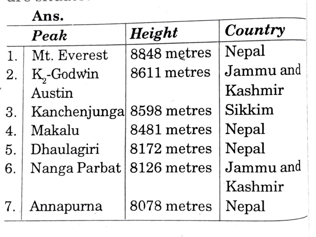
HOTS QUESTION
Q. 1. What do you know about the Shiwaliks? State its features.
Ans. The Shiwaliks are the southernmost range of the Himalayas. We also call them the Outer Himalayas.
(i) They are made of unconsolidated river deposits.
(ii) They are prone to the earthquakes and the landslides.
(iii) The problem of soil erosion is most common.
Q. 2. How are glaciers different from rivers? Write at least three differences.
Ans.
| Glaciers | Rivers |
| (i) They are the moving heap of snow and ice. | (i) Rivers are running water. |
| (ii) They are found either on snow-capped mountains or in the higher latitudes. | (ii) They originate at the mountain tops and come down the plains. |
| (iii) Pindari glacier, Siachen glacier, etc. are some of the examples of glaciers. | (iii) Finally they merge with the big rivers or oceans. |
Q. 3. Write a short note on Andaman and Nicobar Islands.
Ans. Andaman and Nicobar Islands:
(i) The elongated chain of islands located in the Bay of Bengal extending from north to south are the Andaman and Nicobar Islands.
(ii) They are bigger in size and more numerous and scattered than the Lakshadweep lands.
(iii) The entire group of islands is divided into two broad categories, the Andaman in the north and Nicobar in the south.
(iv) It is believed that these islands are an elevated portion of the submarine mountains.
(v) These islands are of great strategic importance for the country.
(vi) They have great diversity of flora and fauna.
Q. 4. How is the exploitation of water and forest resources harmful to the human beings? Explain.
Ans. Biodiversity will be affected on a large scale if there is exploitation of water and forest resources. Animals will lose their natural habitat and climatic changes will occur after a few years.
So, the natural resources of the mountains should be used with care so that the ecology may not seriously disturbed. For this, only a very limited amount of water and forest resources should be used. Trees must be planted regularly to save the forests from exploited.
PASSAGE BASED QUESTIONS
1. Read the given passage and answer the questions that follow:
Geologically, the Peninsular Plateau constitutes one of the ancient landmasses on the earth’s surface. It was supposed to be one of the most stable land blocks. The Himalayas and the Northern Plains are the most recent landforms. From the view point of geology, Himalayan mountains form an unstable zone. The whole mountain system of Himalayas represents a very youthful topography with high peaks, deep valleys and fast flowing rivers.
(i) Which physiographic division of India forms the most stable land blocks?
(a) The Himalayas.
(b) The Peninsular Plateau.
(c) The Coastal Plains.
(d) The Island group.
Ans. (b) The Peninsular Plateau.
(ii) The Gondwana Land refers to:
(a) the land between the mountains and the plains.
(b) the land near the rivers.
(c) the land close to the coastal plains.
(d) the southern part of the ancient super continent Pangea with Angara land in the northern part.
Ans. (d) the southern part of the ancient super continent Pangea with Angara land in the northern part.
(iii) The Shivaliks are also known as:
(a) doab area.
(b) foothills of the Himalayas.
(c) bhabar belt.
(d) Purvanchal.
Ans. (b) foothills of the Himalayas.
(iv) The peninsular plateau is composed of:
(a) igneous and metamorphic rocks.
(b) sedimentary and metamorphic rocks.
(c) sedimentary and igneous rocks.
(d) sedimentary rocks.
Ans. (a) igneous and metamorphic rocks.
2. Read the given passage and answer the questions that follow:
The Himalayas, geologically young and structurally fold mountains stretch over the northern borders of India. These mountain ranges run in a west-east direction from the Indus to the Brahmaputra. The Himalayas represent the loftiest and one of the most rugged mountain barriers of the world. They form an arc, which covers a distance of about 2,400 Km. Their width varies from 400 Km in Kashmir to 150 Km in Arunachal Pradesh. The altitudinal variations are greater in the eastern half than those in the western half.
(i) Which is the most continuous range of the Himalayas?
(a) The Outer Himalayas or the Shivaliks.
(b) The Middle Himalayas or the Himachal.
(c) The Great or Inner Himalayas or the Himadri.
(d) The Purvanchal or the Eastern hills.
Ans. (c) The Great or Inner Himalayas or the Himadri
(ii) What is the core of Himachal composed of?
(a) Granite.
(b) Highly compressed and altered rocks.
(c) Unconsolidated sediments.
(d) Alluvial soil.
Ans. (b) Highly compressed and altered rocks.
(iii) What is its average width of the outermost range of the Himalayas?
(a) The average width of this part of Himalayas is between 2000 to 3000 meters.
(b) The average width of this part of Himalayas is between 1500 to 2000 meters.
(c) The average width of this part of Himalayas is between 900 to 1100 meters.
(d) The average width of this part of Himalayas is between 150 to 500 meters.
Ans. (c) The average width of this part of Himalayas is between 900 to 1100 meters.
(iv) The part of the Himalayas lying between Satluj and Kali rivers is know as ___________.
(a) Punjab Himalayas.
(b) Nepal Himalayas.
(c) Assam Himalayas.
(d) Kumaon Himalayas.
Ans. (d) Kumaon Himalayas.
3. Read the given passage and answer the questions that follow:
The Northern plain has been formed by interplay of the three major river systems, namely-the Indus, the Ganga and the Brahmaputra along with their tributaries. This plain is formed of alluvial soil. The deposition of alluvium in a vast basin lying at the foothills of the Himalaya over millions of years, formed this fertile plain. It spreads over an area of 7 lakh sq. km. The plain being about 2400 km long and 240 to 320 km broad, is a densely populated physiographic division. With a rich soil cover combined with adequate water supply and favorable climate it is agriculturally a productive part of India.
(i) Which of the following is the world”s largest inhabited riverine island in the Brahmaputra river?
(a) Doab.
(b) Sunderban.
(c) Majuli.
(d) Khadar.
Ans. (c) Majuli.
(ii) The Northern Plains are divided into which of the following regions?
(a) Bundelkhand and Baghelkhand.
(b) Bhabar, Terai, Bhangar and Khadar.
(c) Western Ghats and Eastern Ghats.
(d) Doab and Punjab.
Ans. (b) Bhabar, Terai, Bhangar and Khadar
(iii) Distributaries are:
(a) branches of river merging into the sea.
(b) branches of rivers that evolve from the mountains.
(c) branches of the rivers that drain the coastal plains.
(d) the river in their lower course split into numerous channels due to the deposition of silt.
Ans. (d) the river in their lower course split numerous channels due to the deposit of silt.
(iv) Which of the following are the examples of doab in the Northern Plains?
(a) Bhabar, Terai, Bhangar and Khadar.
(b) Pangea and Angara.
(c) Ganga-Yamuna, Malwa and Raichur.
(d) Bundelkhand and Baghelkhand.
Ans. (c) Ganga-Yamuna, Malwa and Raichur.
OBJECTIVE TYPE QUESTIONS
Q. 1. Write False or True against the statements given below:
(a) An elongated and shallow sea is called Tethys.
Ans. True.
(b) Slow moving of stream is called river.
Ans. False.
(c) An I-shaped valley having vertical walls on either side of the river is called Gorge.
Ans. True.
(d) Any gap in mountain range providing a natural route across is called pass.
Ans. True.
(e) Flat low lying lands made of the alluvium is called alluvial plain.
Ans. True.
Q. 2. Fill in the blanks:
(a) _________ is the highest peak of the Malaysia in India.
Ans. Kanchenjunga.
(b) Major part of the Ganga-Brahmaputra Delta lies in ___________.
Ans. Bangladesh.
(c) The southern part of the coast is known as _________.
Ans. Coromandal.
(d) The Eastern Himalayas are not so __________.
Ans. Wide as the Western Himalayas.
Q. 3. Match the items in the two columns:
| A | B |
| Ganga | River the southern peninsula |
| Tapti | Hill station |
| Indus | River associated with Hindu religion |
| Everest | Most part of it in Pakistan |
| Shimla | Highest peak in the world |
Ans.
| A | B |
| Ganga | River associated with Hindu religion |
| Tapti | River of southern peninsula |
| Indus | Most part of it in Pakistan |
| Everest | Highest peak in the world |
| Shimla | Hill station |
Q. 4. Match the name of the river Brahmaputra exactly with the state concerned:
| States/Countries | Names of the River Brahmaputra |
| (i) Central Bangladesh | (a) Tsangpo |
| (ii) Assam | (b) Meghna |
| (iii) Tibet | (c) Brahmaputra |
| (iv) Southern Bangladesh | (d) Dihang |
| (v) Arunachal Pradesh | (e) Jamuna |
| (vi) Northern Bangladesh | (f) Padma |
Ans.
| States/Countries | Names of the River Brahmaputra |
| (i) Central Bangladesh | (f) Padma |
| (ii) Assam | (c) Brahmaputra |
| (iii) Tibet | (a) Tsangpo |
| (iv) Southern Bangladesh | (b) Meghna |
| (v) Arunachal Pradesh | (d) Dihang |
| (vi) Northern Bangladesh | (e) Jamuna |
Q. 5. Match the mountain peaks in Column ‘A’ with their exact altitudes in. Column ‘B’:
| Column ‘A’ | Column ‘B’ |
| (i) Kanchenjunga | (a) 8481 mts. |
| (ii) Nanga Parbat | (b) 8848 mts. |
| (iii) Maikalu | (c) 1722 mts. |
| (iv) Mount Everest | (d) 8126 mts. |
| (v) Annapurna | (e) 8611 mts. |
| (vi) Dhaulagiri | (f) 7817 mts. |
| (vii) Kailash | (g) 6174 mts. |
| (viii) Nanda Devi | (h) 8598 mts. |
| (ix) K-2 | (i) 8078 mts. |
| (x) Guru Shikhar | (j) 8172 mts. |
Ans.
| Column ‘A’ | Column ‘B’ |
| (i) Kanchenjunga | (h) 8598 mts. |
| (ii) Nanga Parbat | (d) 8126 mts. |
| (iii) Maikalu | (a) 8481 mts. |
| (iv) Mount Everest | (b) 8848 mts. |
| (v) Annapurna | (i) 8078 mts. |
| (vi) Dhaulagiri | (j) 8172 mts. |
| (vii) Kailash | (g) 6174 mts. |
| (viii) Nanda Devi | (f) 7817 mts. |
| (ix) K-2 | (e) 8611 mts. |
| (x) Guru Shikhar | (c) 1722 mts. |

Hi! my Name is Parimal Roy. I have completed my Bachelor’s degree in Philosophy (B.A.) from Silapathar General College. Currently, I am working as an HR Manager at Dev Library. It is a website that provides study materials for students from Class 3 to 12, including SCERT and NCERT notes. It also offers resources for BA, B.Com, B.Sc, and Computer Science, along with postgraduate notes. Besides study materials, the website has novels, eBooks, health and finance articles, biographies, quotes, and more.