NCERT Class 9 Social Science Chapter 7 India: Size And Location Solutions to each chapter is provided in the list so that you can easily browse through different chapters NCERT Class 9 Social Science Chapter 7 India: Size And Location and select need one. NCERT Class 9 Social Science Chapter 7 India: Size And Location Question Answers Download PDF. NCERT SST Class 9 Solutions.
NCERT Class 9 Social Science Chapter 7 India: Size And Location


Also, you can read the NCERT book online in these sections Solutions by Expert Teachers as per Central Board of Secondary Education (CBSE) Book guidelines. CBSE Class 9 Social Science Solutions are part of All Subject Solutions. Here we have given NCERT Class 9 Social Science Chapter 7 India: Size And Location and After, NCERT Class 9 Social Science Textbook of India and The Contemporary World – I: History, Contemporary India -I: Geography, Democratic Politics – I: Political Science, Economics and Disaster Management. for All Chapters, You can practice these here.
India: Size And Location
Chapter: 7
CONTEMPORARY INDIA – I (GEOGRAPHY)
NCERT TEXTBOOK QUESTIONS WITH ANSWERS
Q. 1. Choose the right answer from the four alternatives given below:
(i) The Tropic of Cancer does not pass through:
(a) Rajasthan.
(b) Orissa.
(c) Chhattisgarh.
(d) Tripura.
Ans. (b) Orissa.
(ii) The easternmost longitude of India is:
(a) 97°25′ E.
(b) 68°7′ E.
(e) 77° 6′ E.
(d) 82° 32′ E.
Ans. (a) 97°25 E.
(iii) Uttaranchal, Uttar Pradesh, Bihar, West Bengal and Sikkim have common frontiers with:
(a) China.
(b) Bhutan.
(c ) Nepal.
(d) Myanmar.
Ans. (a) China.
(iv) If you intend to visit Kavaratti during your summer vacations, which one of the following Union Territories of India you will be going to:
(a) Pondicherry.
(b) Lakshadweep.
(c) Andaman and Nicobar.
(d) Diu and Daman.
Ans. (b) Lakshadweep.
(v) My friend hails from a country which does not share land boundary with India. Identify the country.
(a) Bhutan.
(b) Tajikistan.
(c) Bangladesh.
(d) Nepal.
Ans. (b) Tajikistan.
Q. 2. Answer the following question briefly:
(i) Name the group of islands lying in the Arabian sea.
Ans. Lakshadweep islands.
(ii) Name the countries which are larger then India.
Ans. (a) Russia.
(b) Canada.
(c) China.
(d) U.S.A.
(e) Brazil.
(f) Australia.
(iii) Which islands group of India lies to its south-east?
Ans. Andaman and Nicobar.
(iv) Which island countries are our southern neighbors?
Ans. Sri Lanka and Maldives.
Q. 3. The sun rises two hours earlier in eastern parts of Arunachal Pradesh as compared to Gujarat in the west but the watches show the same time. How does this happen?
Ans. The earth takes 24 hours to complete one rotation (360°) about its axis. It means the earth rotates at the pace of 15° per hour (360°/ 24). As the longitudinal extent of India is about 30° longitude, the time lag between Easternmost (Arunachal Pradesh) and Westernmost (Gujarat) points of India is of two hours. It happens owing to longitudinal and latitudinal location’s influence.
Q. 4. The central location of India at the head of the Indian Ocean is considered of great significance. Why?
Ans. Significance of location of India at the head of the Indian Ocean:
(i) It provides India with abundant extended sea routes to apply her trade and commerce devices/strategies with developed countries (Western European) at her left hand and developing countries (Orient Asian) at the right.
(ii) It helps India, flowing her stream of wisdom in physical, mental, emotional and psychological fields every where-Africa, Asia and Europe continents. It includes spiritual, technical, physiological, anatomical and material (bilateral trade on goods, metals etc.) knowledge also. India is Jagadguru and Rigveda is the foremost prehistoric scripture in the world-these couple facts prevail.
(iii) India holds title authority on Indian Ocean. In fact, India only has the longest coastline (west and east) in the above said ocean in the world.
MAP SKILLS
Identify the following with the help of map reading:
(i) The Island groups of India lying in the Arabian Sea and the Bay of Bengal.
Ans. Lakshadweep Islands and Andaman Nicobar Islands.
(ii) The countries constituting Indian Subcontinent.
Ans. Pakistan, Afghanistan, China (Tibet), Nepal, Bhutan, Myanmar and Bangladesh.
(iii) The states through which the Tropic of Cancer passes.
Ans. Gujarat, Madhya Pradesh, Chhattisgarh, Jharkhand, West Bengal, Tripura and Mizoram.
(iv) The northernmost latitude in degrees.
Ans. 37° 6′
(v) The southernmost latitude of the Indian mainland in degrees.
Ans. 8° 4′
(vi) The eastern and the westernmost Longitude in degrees.
Ans. 68° 7′ and 97° 25′
(vii) The place situated on the three seas.
Ans. Kanyakumari.
(viii) The strait separating Sri Lanka from India.
Ans. Palk Strait.
(ix) The Union Territories of India.
Ans. Chandigarh, Delhi, Daman and Diu, Lakshadweep, Andaman and Nicobar Islands, Pondicherry and Dadra and Nagar Haveli.
PROJECT ACTIVITY
1. Find out the longitudinal and latitudinal extent of your state.
Ans. Students should do themselves. Degrees are written generally outside every map and North-South and also West-East lines can be drawn to get exact degree of the longitudinal and latitudinal location of concerned state to which they belong.
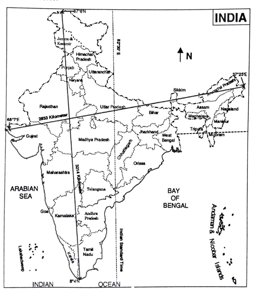
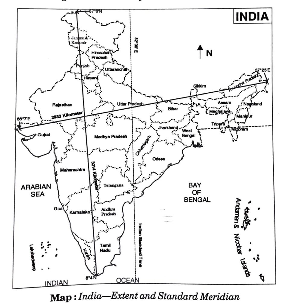
IST is worked out by accepting 82° 30′ E Meridian as the Standard Meridian of India. It passes through Allahabad. By contrasting northward or southward location of the concerned state, we can know-its exact time. IST is five and a half hours ahead of Greenwich Mean Time (GMT).
Eg. If GMT is 8.30 AM. the IST will 2.00 P.M. There is difference of about two hours in the local time of the easternmost part and the westernmost part of India. Eg. One can observe morning in Arunachal Pradesh but it will still night in Gujarat.
2. Collect information about the ‘Silk Route’. Also find out the new developments, which are improving communication routes in the regions of high altitude.
Ans. Students should collect information themselves with proper guidance from teachers concerned.
SOME OTHER IMPORTANT QUESTIONS FOR EXAMINATION
MULTIPLE CHOICE QUESTIONS
Q. 1. The Tropic of Cancer does not pass through:
(a) Rajasthan.
(b) Odisha.
(c) Chhattisgarh.
(d) Tripura.
Ans. (b) Odisha.
Q. 2. The eastern most longitude of India is:
(a) 97°25′ E.
(b) 68°72′ E.
(c) 77°6′ E.
(d) 82°32′ E.
Ans. (a) 97°25′ E.
3. Uttarakhand, Uttar Pradesh, Bihar, West Bengal and Sikkim have common frontiers with:
(a) China.
(b) Bhutan.
(c) Nepal.
(d) Myanmar.
Ans. (c) Nepal.
Q. 4. If you intend to visit Kavaratti during your summer vacations, which one of the following Union Territories of India you will be going to?
(a) Puducherry.
(b) Lakshadweep.
(c) Andaman and Nicobar.
(d) Diu and Daman.
Ans. (b) Lakshadweep.
Q. 5. My friend hails from a country which does not share land boundary with India. Identify the country.
(a) Bhutan.
(b) Tajikistan.
(c) Bangladesh.
(d) Nepal.
Ans. (b) Tajikistan.
Q. 6. How many states and Union Territories does India have?
(a) India has 26 States and 7 Union Territories.
(b) India has 25 States and 7 Union Territories.
(c) India has 28 States and 7 Union Territories.
(d) India has 28 States and 6 Union Territories.
Ans. (c) India has 28 States and 7 Union Territories.
Q. 7. Which meridian is fixed as a Standard Meridian of India?
(a) 821/2° E.
(b) 841/2° E.
(c) 86° E.
(d) 81° E.
Ans. (a) 821/2° E.
Q. 8. The latitudinal extent of India lies between:
(a) 7° 52 N and 26° 52 N.
(b) 8° 42 N and 37° 62 N.
(c) 12° 52 N and 27° 52 N.
(d) 12° 52 N and 37° 62 N.
Ans. (b) 8° 42 N and 37° 62 N.
Q. 9. Tropic of Cancer passes through which of these states?
(a) Odisha.
(b) Tripura.
(c) Bihar.
(d) Punjab.
Ans. (b) Tripura.
Q. 10. Which of the following longitudes is selected as the Standard Meridian for India?
(a) 68°72 E.
(b) 82°302 E.
(c) 97°252 E.
(d) 23°302 N.
Ans. (b) 82°302 E.
Q. 11. Which of the following is the oldest route of contact between India and other countries of the world?
(a) Ocean routes.
(b) Maritime contact.
(c) Land routes.
(d) Air routes.
Ans. (c) Land routes.
Q. 12. India achieved multi-faceted socio-economic progress during which of the following periods?
(a) Since ancient times.
(b) During medieval period.
(c) In the 21st century.
(d) During the last five decades.
Ans. (d) During the last five decades.
Q. 13. Which of the following is the longitudinal extent of India?
(a) 8°42 N and 37°62 N.
(b) 68°72 N and 97°252 E.
(c) 68°72 E and 97°252 W.
(d) 8°42 E and 37°62 E.
Ans. (b) 68°72 N and 97°252 E.
Q. 14. The easternmost longitude of India is:
(a) 97°252 E.
(b) 68°72 E.
(c) 77°62 E.
(d) 82°322 E.
Ans. (a) 97°252 E.
Q. 15. Which latitude passes through the southernmost point of India’s mainland?
(a) 8°42 N.
(b) 37°62 N.
(c) 8°42 S.
(d) 82°302 E.
Ans. (a) 8°42 N.
Q. 16. Which of the following groups of islands belonging to the Indian territory lies in the Arabian Sea?
(a) Andaman and Nicobar Islands.
(b) Sri Lanka.
(c) Lakshadweep.
(d) Maldives.
Ans. (c) Lakshadweep.
Q. 17. Which geographical feature bounds India’s mainland south of 22°N latitude?
(a) Young Fold Mountains.
(b) Sandy Desert.
(c) Lava Plateaus.
(d) Seas and Ocean.
Ans. (d) Seas and Ocean.
Q. 18. Both the latitudinal and longitudinal extent of India’s mainland is about 30°. But on looking at the map of India which of the following alternatives do you observe about India’s size?
(a) East-west extent appears to be smaller than north-south extent.
(b) East-west extent appears to be larger than north-south extent.
(c) East-west and north-south extent appears equal.
(d) North-south extent appears to be smaller than east-west extent.
Ans. (a) East-west extent appears to be smaller than north-south extent.
Q. 19. If the local time at Dwarka (69°012 E) in Gujarat to the west of India is 6 am, what will be the local time at Dibrugarh (94°582 E approximately 95°), in Assam, in the east?
(a) 4.16 am.
(b) 6 am.
(c) 7.44 am.
(d) 7.44 pm.
Ans. (c) 7.44 am.
Q. 20. The Standard Meridian of India, 82°302 E passes through which of the following places?
(a) Kanyakumari in Tamil Nadu.
(b) Walong in Arunachal Pradesh.
(c) Kachchh in Gujarat.
(d) Mirzapur in Uttar Pradesh.
Ans. (d) Mirzapur in Uttar Pradesh.
Q. 21. Which of the following has reduced India’s distance from Europe by 7000 km?
(a) Suez Canal.
(b) Panama Canal.
(c) Indira Gandhi Canal.
(d) Buckingham Canal.
Ans. (a) Suez Canal.
Q. 22. In the question given below, there are two statements marked as Assertion (A) and Reason (R). Read the statements and chose the correct option.
Assertion (A): The trans Indian Ocean routes provide a strategic central location to India.
Reason (R): This route connects the countries of Europe in the West and the countries of East Asia.
Options:
(a) (A) is correct but (R) is wrong.
(b) (A) is wrong but (R) is correct.
(c) Both (A) and (R) are true but (R) is not the correct explanation of (A).
(d) Both (A) and (R) are true and (R) is the correct explanation of (A).
Ans. (d) Both (A) and (R) are true and (R) is the correct explanation of (A).
Q. 23. In the question given below, there are two statements marked as Assertion (A) and Reason (R). Read the statements and chose the correct option.
Assertion (A): India has achieved multifaceted socioeconomic progress during the last five decades.
Reason (R): India has contributed significantly to the making of world history.
Options:
(a) (A) is wrong but (R) is correct.
(b) (A) is correct but (R) is wrong.
(c) Both (A) and (R) are true but (R) is not the correct explanation of (A).
(d) Both (A) and (R) are true and (R) is the correct explanation of (A).
Ans. (c) Both (A) and (R) are true but (R) is not the correct explanation of (A).
Q. 24. In the question given below, there are two statements marked as Assertion (A) and Reason (R). Read the statements and chose the correct option.
Assertion (A): India’s contacts with the World have continued through ages but her relationships through the land routes are much older than her maritime contacts.
Reason (R): India does not occupy an important strategic position in South Asia.
Options:
(a) (A) is correct but (R) is wrong.
(b) (A) is wrong but (R) is correct.
(c) Both (A) and (R) are true and (R) is the correct explanation of (A).
(d) Both (A) and (R) are true but (R) is not the correct explanation of (A).
Ans. (a) (A) is correct but (R) is wrong.
Q. 25. In the question given below, there are two statements marked as Assertion (A) and Reason (R). Read the statements and chose the correct option.
Assertion (A): The sunrises two hours earlier in Gujarat as compared to Arunachal Pradesh in the west but the watches show the same time.
Reason (R): The time along the Standard Meridian of India (82° 30′ E) passing through Mirzapur in Uttar Pradesh is taken as the standard time for the whole country.
Options:
(a) (A) is correct but (R) is wrong.
(b) (A) is wrong but (R) is correct.
(c) Both (A) and (R) are true and (R) is the correct explanation of (A).
(d) Both (A) and (R) are true but (R) is not the correct explanation of (A).
Ans. (b) (A) is wrong but (R) is correct.
Fill in the Blanks:
(i) The Lakshadweep Islands are situated in the __________.
Ans. Arabian Sea.
(ii) A large area of sea partly surrounded by land is called ____________.
Ans. Gulf.
(iii) The __________ is the southernmost tip of the Indian Union.
Ans. ‘Indira Point’.
(iv) __________ is the capital of Sikkim.
Ans. Gangtok.
(v) The sun always shines __________ on the equator.
Ans. vertically.
True and False:
(i) Large landmass on the earth are known as Islands.
Ans. False.
(ii) The earth takes 24 hours to complete one rotation (360°) about its axis.
Ans. True.
(iii) In India, there are 29 states and 7 union territories.
Ans. True.
(iv) In terms of landmass India is the 8th largest country in the world.
Ans. False.
(v) The Suez Canal was opened in 1875 in Egypt.
Ans. False.
VERY SHORT ANSWER TYPE QUESTIONS
Q. 1. What is the longitudinal and latitudinal extension of India?
Ans. The longitudinal extension is 68°72 E to 97°252 E and the latitudinal extension is 8°42 N to 37°62 N.
Q. 2. Name the island group of India lying in the Arabian Sea.
Ans. The Lakshadweep Island.
Q. 3. What is the southernmost latitude of India?
Ans. Southernmost latitude of India is 8°42N.
Q. 4. What is a narrow channel of sea which separates two land masses known as?
Ans. Strait.
Q. 5. What is the total length of the coastline of the mainland of India including its islands?
Ans. Around 7,516.6 kilometers.
Q. 6. Which places in India experience sunrise first and last respectively?
Ans. Arunachal Pradesh experiences sunrise first, and Saurashtra in Gujarat last.
Q. 7. Which longitude represents the Standard Meridian of India?
Ans. Longitude of 82 302 E.
Q. 8. Why has India selected a Standard Meridian of India with an odd value of 82° 302 E?
Ans. India has selected a Standard Meridian of India with an odd value of 82° 302 E because it is divisible by 7°302, a standard adopted by almost all the countries of the world. It lies almost in the middle of India, and as such, it suits us the most.
Q. 9. Name the place said to be the situated on three seas. Name the seas also.
Ans. Kanyakumari. The seas are the Arabian Sea, the Indian Ocean and the Bay of Bengal.
Q. 10. Name the Indian states/union territory which share borders with Pakistan.
Ans. Jammu and Kashmir, Punjab, Rajasthan and Gujarat.
Q. 11. Name India’s neighboring countries in the north-west.
Ans. Pakistan and Afghanistan.
Q. 12. Which neighboring country is situated in the south-west of India?
Ans. Maldives.
Q. 13. Name India’s neighbors on the northern borders.
Ans. China (Tibet), Nepal and Bhutan.
Q. 14. Which two island countries are India’s southern neighbors?
Ans. Sri Lanka and Maldives.
Q. 15. Palk Strait and Gulf of Mannar separate which two countries?
Ans. Sri Lanka and India.
Q. 16. In which year did Indira Point submerge under water due to Tsunami?
Ans. The southernmost point called Indira Point (earlier called Pygmalion Point) got submerged in Tsunami in 2004.
Q. 17. In which island is active volcano found in Andaman and Nicobar islands?
Ans. Barren island.
Q. 18. Andaman and Nicobar Islands lie in which direction with respect to the mainland of India?
Ans. Southeast to the mainland.
Q. 19. Why is the north-south extent of India larger than east-west extent even though the latitudinal and longitudinal extent in degrees is of the same value?
Ans. This is because the distance between two latitudes is always 111 km i.e., always same whereas between two longitudes, it is the maximum at the equator and decreases towards the poles.
Q. 20. Name any two neighboring countries of India which are lying in the east.
Ans. Myanmar and Bangladesh.
Q. 21. Name the two routes by which India is connected with Europe, North America and South America.
Ans. The Cape of Good Hope and the Suez Canal.
Q. 22. Which countries make the Indian subcontinent?
Ans. India, Pakistan, Bangladesh, Bhutan, Nepal, Sri Lanka and the Maldives.
Q. 23. Name a country that shares a common boundary with India.
Ans. Afghanistan.
Q. 24. Name any two states of India that shares its land boundary with Bangladesh.
Ans. West Bengal and Assam.
Q. 25. Name any two Indian states that share its boundary with Nepal.
Ans. Uttar Pradesh and Assam.
Q. 26. Name the neighboring countries that share their boundaries with India.
Ans. Pakistan, Afghanistan, Myanmar, Bangladesh, China (Tibet), Nepal and Bhutan.
SHORT ANSWER TYPE QUESTIONS
Q. 1. What is a subcontinent? Which countries make the Indian subcontinent?
Ans. A subcontinent is a vast independent geographical unit. This landmass is distinctly separated from the main continent. India is a vast country. It is often described as “Indian sub-continent”.
The great mountain wall of Himalayas isolates these countries from the mainland of Asia. India forms the core of the sub-continent; Pakistan is in the north-west, Nepal is in the north, Bhutan is in the north-east, Bangladesh is in the east and Sri Lanka in the south.
Q. 2. ‘India has strategic position in South Asia.’ Explain.
Ans. The relief map of Asia shows that the Indian sub-continent has a distinct identity. The Himalayan mountain system acts as a physical barrier separating it from mainland. It is the most natural geographical unit formed by natural frontiers.
India is situated in the realm of South Asia and has more or less triangular shape. It is centrally located in relation to Asia, Europe, Australia and Africa.
Q. 3. What is the total length of the coast line of India? Explain any two points of its importance to us.
Ans. The total length of the coast line of India is about 7,517 km.
Significance/Advantages:
(a) It has facilitated in establishing many important ports. These are like gateways of India’s foreign trade.
(b) It has helped in developing fisheries. The fishing industry gives employment to thousands of people.
(c) India has been a great naval power in the past. India can again develop her naval force.
(d) India can make use of her sea wealth eg. petroleum, sea salt, etc.
Q. 4. “India is neither a pigmy nor a giant among the nations of the world.” Explain this statement by giving three specific examples.
Ans. (i) It is not pigmy because of her 3.2 million sq. kilometer area equal to the entire continent of Europe. It is not giant because of her area less than a single country of Asian continent i.e. Russia.
(ii) When we compare India in terms of area with only of the other countries in the world, she ranks seventh among the largest countries. Hence, he is neither pigmy nor giant.
(iii) We can assume giant countries the Russia, the USA or the Canada and Sri Lanka, Maldives, Jordan, Israel etc. island countries as pigmy. India stands in the middle of giant and pigmy countries of the world.
Q. 5. Mention the names of India’s relatively distant and close neighbors.
Ans. (a) The distant neighbors are:
(i) Russia.
(ii) Iran.
(iii) Indonesia.
(iv)Thailand.
(v) Malaysia. and
(vi) Sri Lanka.
(b) The close neighbors are:
(i) Pakistan.
(ii) China.
(iii) Nepal.
(iv) Bangladesh.
(v) Myanmar.
(vi) Afghanistan.
Q. 6. Why do we need a Standard Meridian for India?
Ans. The latitudinal and longitudinal extent of India is almost the same in degrees (i.e. 30 degree) but in kilometers, the north-south distance is 3200 kilometers while that of east-west distance i.e. 3000 km. In order to bring uniformity in local time, the Standard Meridian of 82°30’E has been accepted. It passes through Mirzapur (U.P.). Hence, we can state that we need Standard Meridian for India to maintain a standard time.
Q. 7. In what way central location of India in the Indian Ocean has been to it advantage?
Ans. Advantages of Central Location of India in the Indian Ocean:
(i) India has favorably located on international highway of trade and commerce both at the east and the west.
(ii) The sea routes to the east and south east Asia and Australia pass through the Indian Ocean.
(iii) India is connected with Europe, North America through Suez Canal and Cape of Good Hope.
Q. 8. Distinguish between the following: Continent and Subcontinent.
Ans. Difference between continent and subcontinent:
| Continent | Sub-continent |
| 1. A continent is a vast landmass that stands as a separate physical unit such as Asia. | 1. A subcontinent is a part of continent, an independent geo-graphical unit, distinctly separated from the main continent such as India. |
| 2. Asia is a continent. | 2. India is a subcontinent. |
Q. 9. ‘India has contributed significantly to the making of world history.’ Give two facts.
Ans. (i) India is one of the ancient civilisations of the world. Indus Valley Civilisation is one of the ancient civilisations.
(ii) The Aryans settled in India. The traders, invaders, scholars entered India and returned after gaining a lot of knowledge.
Q. 10. What has been the effect of opening of Suez Canal as regards India?
Ans. The Suez Canal was opened in 1869 in Egypt. It reduced the distance between India and Europe by 7000 kms. Now most of Indian trade is carried out through Suez Canal route. Before this, India-European trade was carried through Cape of Good Hope.
Q. 11. In which hemisphere does India lie with reference to Prime Meridian? Mention the value of Prime Meridian of India.
Ans. India lies in the Eastern Hemisphere with reference to Prime Meridian. It is between 68°7′ to 97°25′. 82°30′ longitude has been accepted as the Standard Time throughout India. It has avoided a lot of confusion which would have been created in case, different local times were followed. It has brought harmony in time throughout the country.
Q. 12. Discuss the effects of latitudinal and longitudinal extents of India.
Ans. (i) India has a vast latitudinal extent (8° 4’N to 37° 6’N) due to which its northern parts have extreme climate, i.e., cold winters and hot summers.
(ii) The Tropic of Cancer (23° 30’N) passes through the country. The places situated on this Tropic like Kolkata and Ahmedabad can see the sun overhead twice a year.
(iii) Due to vast longitudinal difference, 68° 7’E and 97° 25’E, the places on the eastern side can see the sun earlier than the places on the western side. There is a time difference of about 2 hours between the easternmost and westernmost places.
Q. 13. India occupies an important strategic position in South Asia. Explain.
Ans. (a) India has the central location between the East Asia and the West Asia, that helps to establish close connection with the South Asian countries.
(b) India shares its land boundaries with
(i) Pakistan and Afghanistan in the north-west.
(ii) China (Tibet), Nepal and Bhutan in the north.
(iii) Myanmar and Bangladesh in the east.
(c) Its southern neighbours are the two island countries, namely Sri Lanka and Maldives.
Q. 14. Why 82° 30′ E has been selected as the Standard Meridian of India?
Ans. There is a time lag of two hours from Gujarat to Arunachal Pradesh. Hence, time along the Standard Meridian of India (82° 30′ E) passing through Mirzapur (almost in the middle of India) is taken as the Standard Time for the whole country.
Q. 15. Why was the Indian Ocean named after India? Give any five reasons.
Ans. (i) The trans Indian Ocean routes which connect the countries of Europe in the west and the countries of East Asia provide a central location to India.
(ii) The Deccan Peninsula protrudes into the Indian ocean.
(iii) It helps India to keep close contact with West Asia, Africa and Europe from the western coast and with Southeast and East Asia from the eastern coast.
(iv) No other country has a long coastline on the Indian ocean as India comprises.
LONG ANSWER TYPE QUESTIONS
Q. 1. Explain that the exchange of ideas and goods from India date back to ancient times.
Or
‘India had strong geographical and historical links with her neighbours.’ Explain giving examples.
Or
India’s strategic location on the head of the Indian Ocean has helped her in establishing land and maritime contacts with the outside world in the ancient and medieval times. Explain.
Ans. India has been linked with S.E. Asia, West Asia, Africa, Central Asia. Indian culture spread to many distant countries such as Indonesia, Bali Island, Cambodia and Egypt. These cultures also has an impact on Indian culture.
(i) The Indian culture spread to distant lands through ocean routes of the Indian Ocean. The muslin, spices were sent to other countries.
(ii) The mountain passes in the north provided many openings and transport facilities for the outsiders.
(a) The pastoral nomads entered India through the mountain passess of Khyber and Bolan.
(b) The Buddhist Bhikshus crossed into Tibet, China and Japan to carry their message of peace.
(c) Alexander invaded India through these mountain passes and brought Greek sculpture of domes, minarets to India.
(d) Indian merchants had trade links with Central Asia, Afghanistan and Iran through these routes.
(iii) The Mongols, Turks, Arabs and Iranians came as conquerors and settled down in India. They took back the Indian numerals, the decimal system and the ideas of the Upanishads to their respective countries.
This give and take, this exchange of ideas, goods and art have enriched the Indian culture.
Q. 2. Describe the importance of geographical location of India.
Ans. (i) Central Location: India is centrally located in the Eastern Hemisphere.
(ii) Trade Routes: India is favourably located for international trade. Many trade routes pass through Indian Ocean.
(iii) Nearness to Tropic of Cancer: The Tropic of Cancer passes through the centre of India. So India is a tropical country. The long growing season makes India an agricultural country.
(iv) Long coastline: India has long coast-line which provides many deep, protected and natural harbours.
(v) Defence: The natural boundaries are favourably located from defence point of view.
(vi) Effect of Indian Ocean: The Indian Ocean leads to the origin of rain giving monsoons.
(vii) Effect of Himalayas: The unbroken chain of Himalayas acts as a climatic barrier. It forces monsoons to give rainfall and protects northern India from cold polar winds.
Q. 3. India, is often referred to as a subcontinent.’ Discuss.
Ans. (i) (a) Arunachal Pradesh lies in the extreme east of India and Gujarat lies in the west.
(b) The time difference between the eastern and western parts of India is about two hours.
(c) This is why, while the sun has risen in Arunachal Pradesh, it is still dark in Gujarat.
(ii) Ahmedabad sees the sun overhead twice in a year because it lies on the Tropic of Cancer.
(iii) The word ‘Meghalaya’ means the ‘abode of the cloud’. It is a mountainous region situated at a height of 1496 m above the sea level. One can see mist and clouds in this region.
(iv) The Indian landmass is a southward extension of the continent of Asia. However, it is cut off from the rest of Asia by the lofty Himalayas. India, therefore, has a separate entity and is called a ‘subcontinent’.
Q. 4. Describe the two important percussions of longitudinal and latitudinal extent of India.
Ans. When we subtract the dimension of two points at longitude and latitude both (viz 37°.6’N- 8°.4’N-30° approx. in latitude and 97° 25′ E- 68°7E = approx. 30° in longitude), we get the difference of 30°. This difference is called latitudinal and longitudinal extent of India.
Important percussions:
(i) Longitudinal extent of 30° makes the land of India proxy to Myanmar, Thailand, Malaysia, Singapore, Vietnam etc. countries of Eastern Asia. Again, on its west, it brings India nearer to Pakistan, Afghanistan, Iran, Iraq including some of Arabian countries in West Asia. This location facilitates bilateral relations in commerce, trade, technical know-how, culture and religion propagation, intellectual services etc. with all these countries.
(ii) Second percussion of vast longitudinal extent is that it has stood India nearer to some other western countries (not of Western Asia) and country at east i.e. Japan (of Asia), and Australia (one of the smallest continents). It also has given birth to bilateral relation in the fields described at column (i) above.
Q. 5. “Unity in diversity” of India is also apparent from her geographical features.” Explain this statement with examples.
Ans. We may quote here Vishnupurana defining India as “the country which lies to the north of the ocean and south of the snow covered mountains is called Bharatvarsa”. India stands apart from the rest of Asia marked off as it is, by mountains and the sea, giving it a distinct geographical entity. For example Pakistan, Nepal, Bhutan, Bangladesh and India form the most natural geographical unit-referred to as the Indian sub-continent. At north, northeast and northwest there are young fold mountains, plateau in south, three seas (Indian Ocean, Arabian sea, Bay of Bengal sea), deserts and plains, islands etc. all existed. Weather and climate here also are diverse. There are grown several types of natural vegetation and species of wildlife, flourish here. It appears aloof but more prosperous with natural resources than any other country of the world.
In context to diversity of India particularly in term of distinct physical features, one can show its parallelism to human beings who live here. Needless to state that numerous castes, creeds, races, religions, customs, rituals etc. live here in peaceful co-existence. Internal clashes, feuds take place here time to time but all these unite into one for her defence from infiltrators, militants, terrorists, invaders of outside India. For example India-China War of 1962, India- Pakistan War of 1965, 1971, 1999 (Kargil), are evident to that unity and integrity among Indian people. People of different beliefs are sewn here with the single thread of patriotism and spirit of extreme nationality.
Thus, we can state that diverse physiographic divisions constitute India the same way as people of diverse beliefs live and defend it with a spirit of oneness and integrity.
Q. 6. Describe the longitudinal extent of India and its advantages to her.
Ans. Longitudinal extent of India is 97°25′ E (at extreme end of Arunachal Pradesh) and 68°7′ E (at extreme end of Gujarat) = about 30°.
Advantages: (i) This east-west extent is quite close to East Asian countries (i.e. Myanmar, Thailand, Malaysia, Singapore, Vietnam) on the eastern sides and to West Asian countries (i.e. Pakistan, Afghanistan, Iran, Iraq, Arab countries) on the western side. India has therefore maintained bilateral trade and commerce relations with these countries since ancient and medieval periods.
(ii) Owing to this longitudinal position, India is quite near to Japan, Australia and other countries of the East and Africa, Europe etc. of the west. Even America lies equidistance to India from both eastern and western sides.
Q. 7. Where do you think the sun’s rays would be direct on the Great Nicobar Islands than on the Jammu and Kashmir state?
Ans. The sun always shines vertically on the equator as such nearer a place is to the equator, the hotter it would be. Because the Great Nicobar Islands are nearer to the equator as compared to Jammu and Kashmir so the sun’s rays would be more direct on the Nicobar Islands than on Jammu and Kashmir. On the other hand, the sun’s rays would be more oblique or slanting on the northern frontiers of India and thus they would bring lesser amount of heat to these areas.
Thus, it may be noted that the Great Nicobar Islands lie quite nearer to the equator where the sun’s rays are always vertically overhead while Jammu and Kashmir state is situated much beyond the Tropic of Cancer i.e. 37.6° N where the sun’s rays are never vertically overhead.
HOTS QUESTION
Q. 1. “India’s contacts with the world have continued through the ages due to its geographic position in Asia”. Explain your view.
Ans. The ideas of the Upanishads and the Ramayana, the stories of Panchatantra, the Indian numerals and the decimal system reached many parts of the world through the ages.
Obviously, the Indian system of values is somewhat different from the values of the Western countries.
We have remained true to our immortal values and influenced the world since the ancient period.
However, we have changed ourselves during the last few years. But in certain cases our ideas are dominating the world.
Q. 2. What is a subcontinent? List countries which constitute the Indian subcontinent.
Ans. A subcontinent is a part of a continent, separated from the rest of the continent by natural features such as mountains and rivers. It has its own specific climatic characteristics and distinct cultural identity.
Countries constituting the subcontinent are listed below:
(i) India.
(ii) Pakistan.
(iii) Bangladesh.
(iv) Afghanistan.
(v) Nepal.
(vi) Bhutan.
(vii) Myanmar.
(viii) Sri Lanka.
(ix) Maldives.
PASSAGE BASED QUESTIONS
1. Read the given passage and answer the questions that follow:
India is one of the ancient civilisations in the world. It has achieved multifaceted socio-economic progress during the last five decades.
It has moved forward displaying remarkable progress in the field of agriculture, industry, technology and overall economic development. India has also contributed significantly to the making of world history.
(i) 68°7’E and 97°25’E is the __________ of India.
(a) Latitudinal extent.
(b) Longitudinal extent.
(c) Coastal extent.
(d) Land extent.
Ans. (b) Longitudinal extent.
(ii) Which imaginary line divides the country into almost two equal parts?
(a) Tropic of Capricorn.
(b) Equator.
(c) Tropic of Cancer.
(d) Standard Meridian.
Ans. (c) Tropic of Cancer.
(iii) India is a country that lies completely in the:
(a) Southern Hemisphere.
(b) Eastern Hemisphere.
(c) Western Hemisphere.
(d) Northern Hemisphere.
Ans. (d) Northern Hemisphere.
(iv) India is bounded by the:
(a) land on all four sides.
(b) sea on all four sides.
(c) young fold mountains in the northwest, north and northeast.
(d) mountains on all four sides.
Ans. (c) young fold mountains in the northwest, north and northeast.
2. Read the given passage and answer the questions that follow:
India is a vast country. Lying entirely in the Northern hemisphere, the mainland extends between latitudes 8°4’N and 37°6’N and Longitudes 68°7’E and 97°25’E. The Tropic of Cancer (23° 30’N) divides the country into almost two equal parts. To the Southeast and Southwest of the mainland, lie the Andaman and Nicobar islands and the Lakshadweep islands in Bay of Bengal and Arabian Sea respectively.
(i) Arrange the countries given below in the chronological order of their area. USA, Australia, Russia, China, Canada, Brazil
(a) Brazil, Australia, Russia, China, Canada, USA.
(b) Russia, Canada, USA, China, Brazil, Australia.
(c) USA, Canada, Russia, China, Australia, Brazil.
(d) USA, Australia, Russia, China, Canada, Brazil.
Ans. (b) Russia, Canada, USA, China, Brazil, Australia.
(ii) The east-west extent appears to be __________ than the north-south extent.
(a) bigger.
(b) higher.
(c) lower.
(d) smaller.
Ans. (d) smaller.
(iii) From _________, there is a time lag of two hours.
(a) Jammu and Kashmir to Tamil Nadu.
(b) Gujarat to Arunachal Pradesh.
(c) Rajasthan to Assam.
(d) Gujarat to Manipur.
Ans. (b) Gujarat to Arunachal Pradesh.
3. Read the given passage and answer the questions that follow:
India is bounded by the young fold mountains in the northwest, north and north east. South of about 22° north latitude, it begins to taper, and extends towards the Indian Ocean, dividing it into two seas, the Arabian Sea on the west and the Bay of Bengal on its East. Despite this fact, the east-west extent appears to be smaller than the north-south extend.
(i) The Standard Meridian of India passing though _________ is taken as the standard time for whole country.
(a) Allahabad.
(b) Kanpur.
(c) Mirzapur.
(d) Varanasi.
Ans. (c) Mirzapur.
(ii) Sri Lanka is separated from India by a narrow channel of sea formed by the __________ and __________.
(a) Suez Canal and Palk Strait.
(b) Palk Strait, Gulf of Mannar.
(c) Suez Canal and Gulf of Mannar.
(d) Indian Ocean and Palk Strait.
Ans. (b) Palk Strait, Gulf of Mannar.
(iii) The Indian landmass has a central location between:
(a) North and South America.
(b) Asia and Europe.
(c) Europe and North America.
(d) East and the West Asia.
Ans. (d) East and the West Asia.
(iv) The trans _________ routes connects the countries of Europe in the West and the countries of East Asia.
(a) Suez Canal.
(b) Atlantic Ocean.
(c) Indian Ocean.
(d) Mediterranean Sea.
Ans. (c) Indian Ocean.
OBJECTIVE TYPE QUESTIONS
Q. 1. Match the following states/stations/ places with their gegree of location.
| I | Il |
| 1. 8°4′ N | (a) Arunachal Pradesh |
| 2. 68°7′ E | (b) Jammu and Kashmir |
| 3. 97°25′ E | (c) Gujarat |
| 4. 37°6′ N | (d) Allahabad |
| 5. 82°30′ E | (e) Indira Point |
| 6. 6°45′ N | (f) Kanyakumari |
Ans.
| I | II |
| 1. 8°4′ N | (f) Kanyakumari |
| 2. 68°7′ E | (c) Gujarat |
| 3. 97°25′ E | (a) Arunachal Pradesh |
| 4. 37°6′ N | (b) Jammu and Kashmir |
| 5. 82°30′ E | (d) Allahabad |
| 6. 6°45′ N | (e) Indira Point |
Q. 2. Match the following states of India having common frontiers with neighbouring countries i.e. China, Nepal and Myanmar:
Himachal Pradesh, West Bengal, Nagaland, Uttarakhand, Uttar Pradesh, Mizoram.
Ans.
| Countries | States |
| China | Himachal Pradesh Uttarakhand, |
| Nepal | Uttar Pradesh, West Bengal |
| Myanmar | Nagaland, Mizoram |
Q. 3. Match the following states with their capitals:
| States | Capital |
| (a) Gujarat | (i) Ranchi |
| (b) Uttarakhand | (ii) Raipur |
| (c) Chhattisgarh | (iii) Shillong |
| (d) Meghalaya | (iv) Shimla |
| (e) Jharkhand | (v) Gandhinagar |
| (f) Himachal Pradesh | (vi) Dehradun |
Ans.
| States | Capital |
| (a) Gujarat | (v) Gandhinagar |
| (b) Uttarakhand | (vi) Dehradun |
| (c) Chhattisgarh | (ii) Raipur |
| (d) Meghalaya | (iii) Shillong |
| (e) Jharkhand | (i) Ranchi |
| (f) Himachal Pradesh | (iv) Shimla |

Hi! my Name is Parimal Roy. I have completed my Bachelor’s degree in Philosophy (B.A.) from Silapathar General College. Currently, I am working as an HR Manager at Dev Library. It is a website that provides study materials for students from Class 3 to 12, including SCERT and NCERT notes. It also offers resources for BA, B.Com, B.Sc, and Computer Science, along with postgraduate notes. Besides study materials, the website has novels, eBooks, health and finance articles, biographies, quotes, and more.