
NCERT Class 11 Geography Chapter 19 Drainage System Solutions to each chapter is provided in the list so that you can easily browse through different chapters NCERT Class 11 Geography Chapter 19 Drainage System and select need one. NCERT Class 11 Geography Chapter 19 Drainage System Question Answers Download PDF. NCERT Geography Class 11 Solutions.
NCERT Class 11 Geography Chapter 19 Drainage System


Also, you can read the NCERT book online in these sections Solutions by Expert Teachers as per Central Board of Secondary Education (CBSE) Book guidelines. CBSE Class 11 Geography Solutions are part of All Subject Solutions. Here we have given NCERT Class 11 Geography Part I: Fundamentals of Physical Geography, Part II: Indian: Physical Environment, Part III: Practical Work in Geography. NCERT Class 11 Geography Chapter 19 Drainage System Notes, NCERT Class 11 Geography Textbook Solutions for All Chapters, You can practice these here.
Drainage System
Chapter: 19
GEOGRAPY [ PART – II ]
SHORT ANSWER TYPE QUESTIONS
Q.1. What is water divide?
Ans. This term has broader implication. It includes the huge land forms where high hills and distribution of water towards the low land takes place. Eg. Himalayas are a water divide.
Q.2. Write the names of the basins formed by the Peninsular rivers.
Ans. These are:
(i) Betul (M.P.).
(ii) Nasik (Maharashtra).
(iii) Chhattisgarh.
(iv) Mahabaleshwar and Brahmagiri range of Western Ghats.
Q.3. In how many categories the Indian rivers are classified?
Ans. (a) The Himalayan rivers.
(b) The Peninsular rivers.
(c) Rivers of Inland drainage.
Q.4. Where in the east the Ganges is bifurcated?
Ans. The Ganga bifurcates or branches off at the northernmost point of the Ganga delta at Farakka in West Bengal. Here the Ganga Splits into two distributaries named Bhagirathi – Hugli and Padma.
Q.5. Where from rise the rivers Ghaghra, Gandak and the Kosi?
Ans. These rivers rise in Nepal Himalayas.
Q.6. Which are the tributaries of the Ganga in Peninsular Plateau?
Ans. The Chambal, the Son and the Damodar. The Son joins the Ganga at Rewelganj near Patna, the Chambal meets at Madhya Pradesh and Damodar meets at West Bengal.
Q.7. What do you mean by Inland drainage?
Ans. When the river water falls into inland sea or lake, it is called inland drainage. Luni river in Rajasthan fall under inland drainage system.
Q.8. How is water the saviour of life?
Ans. (i) Ours all metabolic/digestion systems requires water.
(ii) Our body contains 80% water.
(iii) Water bodies maintain the cycle of climate and temperature.
(iv) All food grains and eatables grow in the presence of water.
Q.9. What is an estuary?
Ans. The tidal mouth of a river where sweet and salty waters forcely mix together is an estuary. It is generally formed when the river falls in the sea.
Q.10. What is dendritic pattern?
Ans. When the tributaries of a stream resemble like the branches of a tree, such pattern is called the dendritic pattern. The main river appears like the trunk of a tree and the tributary streams appear like branches of a tree.
Q.11. What is the trellis pattern?
Ans. In this pattern, the tributaries join the main river at right angles and make it look like a rectangular arrangement.
Q.12. Where is a rectangular drainage pattern developed?
Ans. It develops on a strongly joined rock terrain. Several rectangular spots of large land, this pattern escapes between the tributaries of the main river.
Q.13. What is centrifugal drainage pattern?
Ans. This pattern forms where the streams converge from all sides towards a central depression. It is also called an inland drainage system.
Q.14. What is the radial pattern of drainage?
Ans. When the streams flow down from a dome like structure or a central peak in different directions, it is called the radial pattern of drainage.
Q.15. Mention the course of the Ganges, the Brahmaputra and the Indus rivers.
Ans. The length of the Ganges course is 2490 km, that of Brahmaputra is 2900 km and the course of the Indus river is also 2900 km.
Q.16. Write the length of the peninsular rivers.
Ans. The Narmada (1300 km), the Tapi (792 km), the Mahanadi (885 km), the Godavari (1500 km), the Krishna (1400 km) and the Kaveri (765 km).
Q.17. How much water of the Indus can be used by India as per the treaty with Pakistan?
Ans. Only 20% of the total water.
Q.18. What is the rank of India in the world potential of water resources?
Ans. It is fifth.
Q.19. Write the names of three hydel power projects of Karnataka state.
Ans. (i) Sivasamudram.
(ii) Sharavathy. and
(iii) Kalindi Hydel projects.
Q.20. Why are groundwater resources abundantly found in northern and coastal plains?
Ans. (i) Due to the presence of rocks and more seepage of surface water that recharges the groundwater table.
(ii) These places/regions receive heavy rainfall.
Q.21. Define a drainage system.
Ans. The flow of water through well defined channels is called drainage.
Q.22. What is a drainage pattern?
Ans. The arrangement of rivers and their tributaries is defined as a natural drainage pattern. The drainage pattern of an area is the product of the natural drainage pattern.
Q.23. Give an Indian example of dendritic drainage pattern.
Ans. The drainage pattern of Great Plain is the example of dendritic pattern.
Q.24. What is a drainage basin?
Ans. The watersheds of large rivers are called drainage basin.
Q.25. Name two rivers of central India.
Ans. Chambal and Sind.
Q.26. Name three rivers that flow into the Arabian Sea.
Ans. Narmada, Tapi and Indus.
Q.27. Name the states through which the Subarnarekha and the Brahmani rivers flow.
Ans. Subarnarekha and Brahmani rivers flow through West Bengal and Orissa.
Q.28. What kind of drainage exists in the Thar desert?
Ans. Centripetal drainage exists in the Thar desert.
Q.29. Give two examples of antecedent rivers.
Ans. Brahmaputra and Kosi rivers.
Q.30. Give two examples of consequent rivers.
Ans. Godavari, Krishna and Kaveri.
Q.31. Name two rivers that flow through rift valleys.
Ans. Narmada and Tapi.
Q.32. What is water regime?
Ans. A pattern of seasonal flow of water in a river is called its water regime.
Q.33. When do peninsular rivers have maximum flow?
Ans. In rainy season.
Q.34. Write three characteristics of the peninsular river.
Ans. 1. These rivers are rainfed.
2. These rivers are of medium length.
3. These rivers are matured and their valleys are shallow.
Q.35. Name the main watershed of peninsular rivers.
Ans. Western Ghats.
Q.36. Name the sources of Indus.
Ans. Mansarovar lake.
Q.37. Name the tributary of the Ganga which flows from south to north.
Ans. Son river.
Q.38. Name the two headstreams of the Ganga which unite near Devprayag.
Ans. The two headstreams of Ganga are:
(i) The Alaknanda.
(ii) The Bhagirathi.
These two head streams unite at Devprayag and the Ganga acquires its name here.
Q.39. Name two west flowing rivers of peninsular India.
Ans. The two west flowing rivers of Peninsular India are:
(i) Narmada. and
(ii) Tapi.
Q.40. Give an account of the straight line of Narmada river for a stretch.
Ans. The Narmada flows in trough faults created by subsidence of northern flank of the Peninsular block at the time of the upheaval of the Himalayas. That is why Narmada river follows the straight line course for a stretch. The Narmada could not carve its own valley.
Q. 41. Name the three main Himalayan river systems.
Ans. The three Himalayan river systems consists of:
(i) The Indus system.
(ii) The Ganga system
(iii) The Brahmaputra system.
Q.42. Which river is called Dakshin Ganga?
Ans. The river Godavari.
Q.43. Where is the Jog Falls located?
Ans. At Shabarmati river.
Q.44. Name a river which falls into the Gulf of Khambat.
Ans. Mahi.
Q.45. Name trans-Himalayan rivers .
Ans. Trans-Himalayan rivers are:
(i) Indus.
(ii) Brahmaputra.
(iii) Satluj.
Q.46. What is the source of river Jhelum?
Ans. Wulur lake in Jammu and Kashmir.
Q.47. Describe the salient features of the Kaveri basin.
Ans. Kaveri rises in Brahamgiri (1341m) of Coorg district in Karnataka. Its length is 800 km. and drains an area of 67900 km². The river carries water throughout the year with comparatively less fluctuation than other peninsular rivers.
Q.48. What is a gorge? Give examples.
Ans. A gorge is a narrow deep valley with steep sides. Its bank is rising while its bed is deepend due to down cutting of the river. Many deep gorges are found in the Himalayas such as Indus Gorge, Satluj, Dihang Gorge.
Q.49. Which peninsular river lacks a developed tributary system?
Ans. Narmada river flows through a rift valley. It is a peninsular river. It has no long tributary. None of the tributaries is more than 200 km long.
Q.50. Where does the river Indus rise? Name its five important tributaries.
Ans. The river Indus rises in Tibet at an altitude of 5180 meters near Mansarover lake. It is a trans-Himalayan river. It flows west and north-westwards and reaches the Arabian sea. Its five important tributaries are the Jhelum, the Chenab, the Ravi, the Beas and the Sutlej.
SHORT ANSWER TYPE QUESTIONS
Q.1. Distinguish between a glaciers and a river.
Ans.
| The Glaciers | Rivers |
| 1. Glaciers are in solid form and these look like mountains of ice. | 1. Rivers are in liquid form of water and these flow in streams. |
| 2. Glaciers move very slowly and it appears that they are stable. | 2. Rivers move with a greater speed and their movement is easily discernible. |
Q.2. Write the salient characteristics of the Ganga-Brahmaputra Delta.
Ans. (i) It is the largest delta of the world on the mouth of the Bay of Bengal.
(ii) This has formed owing to split of Ganges and the Brahmaputra in several rivulets i.e. distributaries.
(iii) Its lower portion is marshy owing to mess of the sea and the fresh water together.
(iv) It is the most densely populated and is up fertile delta.
Q.3. Why are the peninsular rivers not navigable?
Ans. It’s reasons are as under:
(i) These all are seasonal rivers and generally remain dried up in the summer.
(ii) River beds are uneven, rocky and have a steep gradients.
(iii) Construction of several dams also has made navigation through these rivers impossible.
Q.4. Describe some specific characteristics of the Brahmaputra river system.
Ans. (i) It originates from Tibet and is as long as the Indus.
(ii) It carries huge amount of silt.
(iii) It flows parallel to the Himalayan mountains in Tibet.
(iv) It takes U-turn at Namcha Barwa (height 7757 m) and enters into Arunachal Pradesh.
(v) It flows into the Bay of Bengal and the just before falling into it, it forms braided streams of the distributaries due to excess deposits of sediments and silts.
Q.5. What is common between river Damodar and the river Kosi?
Ans. One thing common between both Damodar and Kosi is that they have been called rivers of sorrow. Widespread floods occur in both the rivers leading to the loss of life and property. Damodar has been tamed now but only partial success has been achieved in controlling the migration tendencies of Kosi which is still perceived as “The Sorrow of Bihar’.
Q.6. Write three characteristics of the Peninsular rivers.
Ans. These rivers originate in peninsular plateau and central highland. These are seasonal rivers as these are dependent on monsoons rainfall. They reflect super imposed type of drainage pattern and rejuvenated resulting in trellies radial and rectangular patterns. These rivers smaller having fixed course with well adjusted valleys. Their catchment area in the relatively smaller basin. These rivers are old rivers with graded profile and have almost reached their base levels.
Q.7. Distinguish between a tributary and a distributary.
Ans. Tributary: A tributary is a small stream of river. It is formed of springs, nallahs, fountains etc. It meets to the main river at a certain place. E.g. Confluence of the Ganges, Yamuna and Saraswati at Prayag.
Distributary: The water of the main river when finds no channels to flow forward, particularly when the silt, sediments and alluvium deposited at its mouth so enough as its forward flow is restricted; the force of river then cuts several small channels. These channels thus, distribute the integral force of the main river in several streams. E.g. Braided bed of Ganga- Brahmaputra delta in Assam and Bengal regions.
Hence, functionally, a tributary and a distributary are opposite to each-other. The former adds to while the later reduces to the force of the main river.
Q.8. How are Indian rivers useful for the country?
Ans. The great river system comprises large water wealth of the country. The volume of annual precipitation in the country is estimated at about 3700400 million cubic meters. Large rivers have great water power potential. Large rivers and lakes possess some important and useful waterways of the country. The country has navigable waterways of about 10600 km. The rivers also supply water to cities, villages and industrial sectors.
Q.9. Write a note on the Ganga basin.
Ans. The Ganga is the most sacred river of India. The story of Ganga from the source of the sea from old time to the new is the story of India’s civilisation and culture. The Ganga has it source near Gomukh glacier near Gangotri. The Ganga is formed by the two headstreams namely-Alaknanda and Bhagirathi. It enters the plains near Haridwar. The Yamuna meets it at Sangam in Allahabad. South of Farakka; the river divides into a number of channels to form Sunderban Delta. The Ram Ganga, Ghaghra, Gandak, Bhagmati etc. join the Ganga from its left. The Yamuna and Son etc. join it from the right. It is 2525 km long.
Q.10. Distinguish between Consequent and antecedent rivers:
Ans.
| Consequent rivers | Antecedent rivers |
| 1. These rivers maintain their original shape, deposit, the rise of the land due to folding. Rivers keep on flowing in the original direction. | 1. It is an uplift area, the rivers flow in the direction resulting as a consequence of the slope. |
| 2. These rivers are older than the fold mountains over which these rivers flow. | 2. These rivers are formed after the uplift of the area. |
| 3. These rivers cut deep gorges due to down cutting. | 3. These rivers do not form gorges. |
| 4. The trans Hima-layan rivers such as Indus, Satluj, Kosi, represent consequent rivers. | 4. The rivers in the peninsular India flowing eastward according to slope are antecedent rivers. |
Q.11. Why is Godavari river often referred to as Dakhin Ganga or Virdha Ganga?
Ans. The Godavari is the largest river of the peninsular river system. Hence it is known as Dakhin Ganga or Virdha Ganga. It is almost equal to Ganga in its size and extent. It has also a large number of tributaries such as Indira, Jati, Sabri and Wain Ganga. It has got the same cultural significance as the Ganga in the north.
Q.12. Describe the characteristics of the Brahmaputra basin. Also mention why flood is a frequent feature in this basin.
Ans. (i) Brahmaputra is one of the largest rivers of the world. It is a trans-Himalayan river. It has its origin in Kailash range near Mansarover lake. It flows eastward longitudinally from a distance of 1200 km. It forms a gorge in Namcha Barwa mountains. It enters India forming the gorge. It receives Dibang and Lohit rivers as its tributaries. The Brahmaputra is known for its floods. This is due to the fact that both the Purvanchal Himalayas and the Shillong Plateaus receive heavy rainfall.
Q.13. What is Delta? Give four examples from India.
Ans. A delta is a triangular piece of low land formed at the mouth of the river. It is formed due to deposition by the river at its lower course.
Four examples of deltas in India are:
1. Ganga-Brahmaputra delta.
2. Mahanadi delta.
3. Krishna delta.
4. Kaveri delta.
Q.14. Distinguish between.
(i) River basin and Watershed.
Ans. Watershed: Watershed is an area which is drained by a river. It is demarcated by a line that separates the watershed of one river from the adjoining ones. These are small areas less than 1000 hectares.
River basin: The watersheds of large rivers are called river basin.
(ii) Delta and Estuary.
Ans. Delta: A delta is a triangular piece of alluvial low land formed at the mouth of the river. It is formed due to deposition by the river at its lower course.
Estuary: Those rivers which do not form deltas, form estuaries. These rivers do not deposit sediments on their mouth, and carry the materials into the sea or ocean. This mouth is called estuary. Example: Narmada and Tapi make estuaries.
(iii) Radial and Centripetal drainage.
Ans. Radial drainage: When the rivers radiats from a hill, the pattern is called radial.
Centripetal drainage: The rivers flowing into a depression or a lake, is called a centripetal drainage. The desert is characterised by the centripetal drainage pattern.
(iv) Gorge and rift valley.
Ans. Gorge: The rivers in the mountainous region cut deep valleys and flow through these valleys. These are called gorges. The gorges are steep-sloped and deep.
Rift valley: Rift valleys are formed due to faulting. Due to the internal disturbances of the earth, some regions sink and form a valley. This valley is called a rift valley.
(v) Cusecs and Cumecs
Ans. Cusecs: The discharge of the volume of water flowing in the river is measured over time. When the water is measured in cubic feet per second, it is called cusecs.
Cumecs: When the water flowing in the river is measured in cubic metre per second, it is called cumecs.
(iv) East flowing rivers and rivers West flowing peninsular rivers.
Ans.
| East flowing peninsular rivers | West flowing peninsular rivers |
| 1. The rivers flowing eastward on the peninsular plateau are generally large. | 1. The rivers flowing westward on the peninsular plateau are generally small but rivers Narmada and Tapi are exception to this. |
| 2. These rivers form huge deltas near their mouth. | 2. These rivers do not form deltas. |
| 3. These rivers do not flow through trough. | 3. West flowing rivers like Narmada and Tapi flow through troughs which have been formed due to faulting. |
| 4. These rivers fall into Bay of Bengal. | 4. These rivers fall into Arabian sea. |
| 5. The Mahanadi, Godavari, Krishna and Kaveri are east flowing rivers. | 5. The Narmada and Tapi are west flowing rivers. |
(vii) The Himalaya Rivers and the Peninsular Rivers.
Ans.
| The Himalayan Rivers | The Peninsular Rivers |
| 1. Catchment area: The catchment area of the Himalayan river system is very large and extensive. It is spread over hundreds of thousand square metres. | 1. The catchment area of the peninsular river system is comparatively small and spreading over a limited area. |
| 2. Terrain: The Himalayan rivers flow into the deep gorges in the mountainous region and form meanders in the plains. These rivers have the intensive erosional capacity as they carry the huge loads of silt and sands annually. | 2. The rivers of the peninsular river system flow in large graded and shallow valleys. These rivers have lesser erosional capacity as they have mostly acquired maturity. The peninsular rivers flow over hard rock bed, hence they show very little meandering. |
| 3. Flow pattern: The Himalayan rivers are perennial as they derive their water from rainfall as well as the snow melt. The Himalayan rivers consist of three systems. The rivers of Indus system flow towards south-west and drain into Arabian sea. The rivers of Ganga system and Brahmaputra system flow eastward and drain into Bay of Bengal. They form deltas near their mouths. | 3. The peninsular rivers are seasonal as they are rainfed. Most of the peninsular rivers flow eastward on the plateau and drain into Bay of Bengal. They form deltas near their mouths. Narmada and Tapi rivers are the important west flowing streams which flow into rift valleys. |
Q.5. State the different between the following:
(a) River basin and Watershed.
Ans.
| River Basin | Watershed |
| 1. The watersheds of large rivers are called river basins. | 1. Small rivulets and rills are called watershed. It is also known as catchment area. |
| 2. The basins cover a large area. | 2. It covers less than 10 sq. Km area. |
(b) Dendritic and Trellis drainage pattern.
Ans.
| Dendritic Drainage Pattern | Trellis drainage pattern |
| 1. It develops similar to branches of a tree and called dendritic pattern. | 1. In trellis pattern primary tributaries flow more or less parallel to one another. The secondary tributaries join from the sides more or less at right angle. |
| 2. The drainage pattern of Northern Plain is the example of such pattern. | 2. This pattern is found in Himalayan mountain. |
(c) Radial and Centripetal drainage pattern.
Ans.
| Radial Pattern of Drainage | Centripetal Pattern of Drainage |
| 1. The river radiating from a hill is called radial. | 1. In this pattern the rivers flows into a lake of depression. |
| 2. The Son river in Amarkantak Plateau is good example of radial drainage pattern. | 2. Sambhar lake of Rajasthan is the good example of the pattern. |
(d) Delta and Estuary.
Ans.
| Delta | Estuary |
| 1. A delta is a triangular shaped land formed at the mouth of a river. | 1. An estuary is a funnel-shaped channel formed at the mouth of a river. |
| 2. It is formed by deposition. | 2. It is formed when deposition does not take place due to strong tides and currents. |
| 3. Ganga and Brahmaputra form a large delta catted Sunderbans. | 3. Narmada and Tapi make estuaries. |
LONG ANSWER TYPE QUESTIONS
Q.1. What are the socio-economic advantages of interlinking of rivers in India?
Ans. The socio-economic advantages of interlinking of rivers in India are as under:
1. The surplus water can be transferred to the deficit areas.
2. When there is a flood in one part of the country the water can be used in other drought like areas for irrigation.
3. Hydro electricity can be generated in the areas by interlinking of rivers.
Q.2. Suppose you are travelling from Haridwar to Siliguri along the foothills of the Himalayas. Name the important rivers you will come across. Describe the characteristics of any one of them.
Ans. Travelling from Haridwar to Siliguri, we have to cross the following rivers:
Ramganga, Gomati, Ghaghra, Rapti, Gandak, Kosi and Mahanadi.
Characteristics of Ghaghara:
1. It originates in glacier of Mount Chachungo.
2. It collects the water of Tila Seti and Beri.
3. It cuts a deep gorge of 600 m at Shishapani.
4. The river Sarda or Kali Ganga joins it in the plains.
5. It meets Ganga at Chhapra.
6. Its length is 1080 km.
Q.3. Why do rivers have no deltas on the western coast even though they transport a lot of sediments with them?
Ans. The Narmada and Tapi are the main rivers flowing westward on the western coast. These rivers carry a large amount of sediments with them but these rivers do not form any delta near their mouth. These rivers form estuaries.
The west coast are not marked with favourable condition required for the formation of a delta. The lower courses of these have steep slopes. The rivers had swift current. The rivers are unable to deposit their sediments at their mouths. These rivers do not have any large tributaries to add to their sediments. These rivers flow through rift valleys. Most of sediments are deposited in these troughs. Due to the subsidence deep estuaries are formed near their mouths. Thus these rivers have no deltas on the west coast due to lack of favour at physical conditions.
Q.4. Describe the water resources of India. Explain the concept of watershed management.
Ans. Water is vital for realising the potential of the agriculture sector and the country’s development. It is the primary need of people. Water is used for irrigation, generation of water power and industrial purposes. Thus rivers are a useful natural resource. The average run off the river system of the country has been assessed as 1869 km³ of which the utilisable part is about 690 km³. Optimum development and efficient utilisation of our water resources, therefore assumes great significance.
Watershed: Most of the water runs off on the land in the direction of slope in area which separates the two drainage systems is called watershed, for example Satluj, Yamuna divide their water near Ambala. Main watersheds of India are:
(i) Himalayan range.
(ii) Vindhya-Satpura range.
(iii) Western Ghats.
Concept of Watershed Management: The main aim of watershed management is the sustainable development of land, water, vegetation and other resources of the area. It aims at the sustainable use of resources for future generation. Many projects are run as reclaim wasteland, drought-affected areas, soil conservation, welfare scheme for tribal areas and agriculture development as the parts of watershed development.
Objectives of Watershed Management:
1. To check soil erosion.
2. To form reservoirs and regulate water surplus.
3. Better cropping pattern to be adopted to suit the water resources of the area.
4. The local people participation.
5. To use new methods of irrigation as sprinkle method, drip irrigaiton etc.
6. To maintain the level of underground water.
7. Watershed is a basic unit of development for large areas.
8. Soil erosion is prevented by check dams and ploughing gullies.
9. Cattle grazing is properly done on pastures.
10. Remote sensing methods are used for the large areas.
Q.5. What are the important characteristic features of the North Indian rivers? How are these different from Peninsular rivers?
Ans. Characteristics of North Indian rivers:
1. The North Indian rivers have evolved through a long geological history.
2. It includes Ganga, Brahmaputra and Indus river basins.
3. These are fed by melting of snow and precipitation.
4. These are perennial rivers.
5. These rivers form deep gorges and V-shaped valleys in mountainous areas and when they enter plains they form flat valleys, flood plains etc.
The northern rivers differ from the peninsular rivers in the following ways:
1. The catchment area of northern rivers is very large while the catchment area of peninsular rivers is small.
2. The northern rivers flow in deep gorges in the mountains and they form meanders in plains; while peninsular rivers do not have formations.
3. Northern rivers are perennial as they derive their water from snow melt and rainfall while peninsular rivers depend on only monsoons.
Q.6. Explain briefly the theory of the “Indo-Brahma” river as believed by some geologists. Also mention the three principal grounds on which the theory has been discarded.
Ans. It is believed by some of the geologists that there was a mighty river named Siwalik or the Indo-Brahma. It flowed north-west from Assam to Punjab in the longitudinal valley along the foot of the Himalayas. From there, it took a southerly turn to join a gulf which occupied parts of the Sindh and the lower Punjab during the Miocene period.
It is also believed that this mighty river carried the combined flow of the Himalaya rivers and the main streams of the Brahmaputra, Ganga and the Indus.
The sediments brought by this mighty river formed the Siwalik range. Due to the uplift of the western Himalayas, the mighty stream dismembered into the following river systems and subsystems:
(i) The Indus system.
(ii) The five tributaries of the Indus in Punjab.
(iii) The Ganga and its Himalayan tributaries.
This dismemberence changed direction of present Ganga and Yamuna. According to this theory, the Yamuna was the tributary of Indus before this event took place and had south-westerly course. This interchange of tributaries between the Indus and the Ganga systems in the region lying between the headstreams of the Sutlej and Yamuna has been a common phenomenon in the geologic recent past.
Arguments Against the Theory: The theory of Indo-Brahma has not been accepted universally. It has been challenged on the following grounds:
Firstly, the concept of such a mighty river Indo-Brahma flowing all along the longitudinal extent of the Himalayas is not possible. The occurrence of Siwalik alluvial deposits might have been formed by successive deposition of alluvial fans by the rivers flowing down the Himalayan slopes.
Secondly, the evidence furnished by the depositional history in the Ganga delta and in the Assam does not prove this concept as the deposits in the gap lying between the two projections of the peninsular block-Rajmahal hills and Shillong plateau, have been composed of thick alluvium older than that suggested by the Indo-Brahma theory.
Thirdly, the evidences of Tipan sandstorm of Assam has not been accepted by this theory.
Q.7. How is the regime of the Himalayan rivers different from the Peninsular rivers?
Ans. The flow pattern of Himalayan rivers and peninsular rivers is controlled by the climatic conditions.
The Ganga: As its hydrograph shows that the flow pattern of the Ganga attains the sizeable flow in the early summer because of snow-melting. Its maximum flow is either in August or September and minimum in the period of December and January.
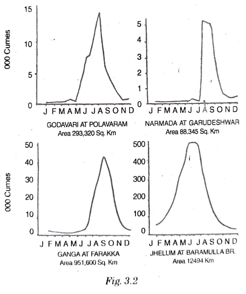
The Godavari: As its hydrograph shows that the flow pattern of Godavari river has also seasonal effects. Its flow is low until May. It has two maximas-one in May-June and other in July- August. After August, its flow pattern falls sharply but it has higher flow in October and November also.
The Narmada: The hydrograph shows that the flow pattern of Narmada is also seasonal. It is high in the months of June to September and October during the rainy season. During winter it is low.
The Jhelum: The flow pattern of Jhelum is high throughout the year, because it is due to snow melting and rainfall in the region.
Q.8. Write an essay on the drainage system of India.
Ans. This blue planet which we call our earth is actually because it is gifted with immense water bodies. There is water two-third of the total area of the world. Apart from the seven oceans and a number of seas, India in particular has a number of surface water bodies viz. rivers, lakes, reservoirs, inland drainage systems etc.
The term drainage is technically used for the river system of an area. India’s drainage system is grouped in
(i) The Himalayan rivers. and
(ii) The Peninsular rivers. Apart from this, there are inland drainage systems also.
The Himalayan rivers are the Indus, the Ganges and the Brahmaputra. The Indus water drains only 17,844 sq. km area in India because it flows outside the border of India since its rise from the Kailash range of Greater Himalayas. Its tributaries are the Zaskar, Shyok, Jhelum, Chenab, Ravi, Beas and Satluj. Indus is one of the largest river basins in the world, but its course in India is only 709 km.
The Ganges rises from Gangotri glacier and at the beginning, it is called Bhagirathi. Alaknanda meets it at Devprayag in Garhwal region and then it is named as Ganga. The Ganga with its tributaries viz. Yamuna, Ghaghra, Gandak, Kosi, Son, Chambal and Betwa drains 9,51,600 sq. km area and falls into the Bay of Bengal.
Brahmaputra rises from the Kailash range of Greater Himalayas near Mansarover. It flows eastwards parallel to the Himalayas to its south. It enters into India west of Sadiya town in Arunachal Pradesh. Its tributaries are Raja Tsangpo, Lhotse, Subansiri, Tista, Torsa and Dihang. It is long as the Indus and drains 5,80,000 sq. km area in India.
All these three major rivers fall into the Bay of Bengal.
Among Peninsular rivers, there are the Narmada, the Tapi, the Mahanadi, the Godavari, the Krishna and the Kaveri known as major rivers. The length of the Narmada and the Tapi are 1300 and 792 km respectively. The area drained by them is 93,080 and 792 sq. km respectively. These fall into the Arabian sea. Mahanadi rises in Chhattisgarh with its length 885 km and area drained is 1,92,000 sq. km Godavari rises in Nasik (Maharashtra). Its length is 1400 km and area drained by it is 2,60,000 sq. km. Kaveri rises from Brahmagiri hills. It drains 72,000 sq. km area and its length is 765 km. All these fall into the Bay of Bengal.
According to the slope of land, underlying rock structure and climatic conditions of the area, the rivers form dendritic (tree-like shapes), trellis, rectangular, radial and centifugal patterns. Ghaghar river of Haryana forms the centrifugal pattern of inland drainage.
The Himalayan rivers are perennial but the peninsular rivers are seasonal at the most. Owing to different rock structures, these form estuaries, gorges, water divide, rift valleys, basins, delta, doab etc. land-forms. Ganga- Brahmaputra delta or the Sunderban delta is the largest delta in the world.
Lakes are grouped into two i.e.
(i) Natural lakes.
(ii) Man-made lakes (or dams).
Some natural lakes are Wulur, Dal, Nainital, Bhimtal, Loktak, Barapani, Chilka, Sambhar, Vembanad, Pulicat. Man-made lakes are: Govind Sagar (Bhakra), Ranapratap Sagar, Nizamsagar, Nagarjunsagar, Gandhi Sagar and Hirakud. Some lakes are formed owing to the action of glaciers and ice sheets while some other are formed by wind, river action and human activities.

Hi! my Name is Parimal Roy. I have completed my Bachelor’s degree in Philosophy (B.A.) from Silapathar General College. Currently, I am working as an HR Manager at Dev Library. It is a website that provides study materials for students from Class 3 to 12, including SCERT and NCERT notes. It also offers resources for BA, B.Com, B.Sc, and Computer Science, along with postgraduate notes. Besides study materials, the website has novels, eBooks, health and finance articles, biographies, quotes, and more.
 Buy Now