
Class 9 Geography Elective Chapter 1 Weather and Climate The answer to each chapter is provided in the list so that you can easily browse throughout different chapters SEBA Class 9 Geography Elective Chapter 1 Weather and Climate, Elective Geography Class 9 SEBA Notes and Question Answer In English Medium and select need one.
Class 9 Geography Elective Chapter 1 Weather and Climate


Also, you can read the SCERT book online in these sections Solutions by Expert Teachers as per SCERT (CBSE) Book guidelines. These solutions are part of SCERT All Subject Solutions. Here we have given Assam Board Class 9 Geography Elective Chapter 1 Weather and Climate Solutions for All Subjects, You can practice these here.
Weather and Climate
Chapter – 1
TEXTUAL QUESTION AND ANSWERS
Q.1. What do you mean weather and climate? Distinguish between weather and climate.
Ans: Even though both weather and climate include some similar atmospheric elements, there are some prominent differences between these two.
Here are some The difference between climate and weather is:
| Climate | Weather |
| Forecast | Aggregate meteorological statistics for 30 years. |
| Determining factors | Aggregation of meteorological statistics for 30 years (“normal value”) |
| About | Climate is defined as statistical weather information that describes climate change at specific intervals at specific locations |
| Time period | It is measured for a long period of time |
| Study | The study of climate is known as climatology |
Q.2. Mention the elements of weather and climate?
Ans: The six main elements are weather and climate are:
1. Temperature.
2. Atmospheric pressure.
3. Wind.
4. Humidity.
5. Precipitation. and
6. Cloudiness.
Q.3. State the main element of weather and climate.
Ans: The elements of weather and climate are those quantities or properties that are measured regularly.
The six main elements are weather and climate are:
1. Temperature.
2. Atmospheric pressure.
3. Wind.
4. Humidity.
5. Precipitation. and
6. Cloudiness.
Humidity is the concentration of water vapor present in the air. Humidity depends on the temperature and pressure of the system of interest.
Q. 4. Explain he relationship among temperature, pressure and humidity?
Ans: The relationship between pressure and temperature is described by the Ideal Gas Law, which states that PV = nRT, where P is pressure, V is volume, n is number of moles, R is the universal gas constant, and T is temperature. This means that at a constant volume, the pressure of a gas will increase as the temperature increases.The relationship between humidity and pressure is that air can hold more water vapor at higher pressures. When air is cooled, it can’t hold as much water vapor, so the excess water vapor condenses into liquid or solid form. This is why we see dew forming on surfaces on cool nights, or clouds forming when air rises and cools.The relationship between temperature and humidity is that warm air can hold more water vapor than cool air. This is why we often see higher humidity in tropical regions, where temperatures are consistently high.
Q. 5. How are the variation in atmosphere pressure caused?
Ans: Atmospheric pressure varies as follows:
(i) Temperature of the air.
(ii) Amount of water vapor in the air.
(iii) Height of the earth’s surface.
(iv) Rotation of the earth.
(v) Height of the air layer.
(i) Warming of air: Variation of air pressure is caused by warming of air. When air is heated, the volume of air increases and the density of air decreases. As a result, the air becomes lighter. Light air pressure also decreases. Therefore, when the temperature in the air is high, the air pressure is low. Similarly, when the temperature of the air decreases, the density of the air increases, so the air pressure also increases. Air pressure is completely dependent on temperature. Air pressure varies inversely with temperature, that is, when temperature decreases, air pressure increases and when temperature increases, air pressure decreases.
(ii) Variation of water vapor in air: Variation of water vapor in air causes variation in air pressure. Water vapor is lighter than pure air. Therefore, the air that contains more water vapor is lighter than dry air and its pressure is relatively low. Due to this, the air pressure is low as there is more water vapor in the air during monsoons. Dry air is heavy and has high pressure.
(iii) Elevation of the Earth’s surface: Air pressure varies with the height of the earth’s surface. As one rises above the sea level, the depth and density of the atmosphere decreases. That is, with the increase in height, the density of the air layer decreases. As air density decreases, the weight of air naturally decreases, and as weight decreases, air pressure also decreases. Generally, air pressure decreases by 1 inch for every 900 feet of altitude, or 34 millibars for every 274 meters. However, at this rate the air pressure in the upper air layer does not decrease at all times. Because the upper air layer is getting thinner.
(iv) Rotation of the Earth: Due to the rotational speed of the Earth, the air pressure also varies. As a result of the rotation of the earth, the air currents tend to be thrown outwards. Due to this, there is a difference in air pressure.
(v) Air level height: Air pressure varies with air level height. The part of the lowest layer of gaseous matter that is adjacent to the earth’s surface under the influence of gravitational attraction is generally known as the atmosphere. Although the upper limit of the atmosphere is considered to be about 10,000 km, 99% of the mass of the atmosphere is located within 32 km of the earth’s surface. It is in this part of the atmosphere that the solar heat is stored and it is in this part that we feel the pressure.
Q. 6. Why does wind blow?
Ans: Gases move from high-pressure areas to low-pressure areas. And the bigger the difference between the pressures, the faster the air will move from the high to the low pressure. That rush of air is the wind we experience.
Wind is a part of weather we experience all the time, but why does it actually happen? The air will be still one day, and the next, powerful gusts of wind can knock down trees.
Q.7. What is precipitation? Name the different types of precipitation.
Ans: It is a chemical reaction in which you mix two solutions of two ionic substances and a solid ionic substance (a precipitate) forms.
The different types of precipitation are:
- Rain. Rain is a form of precipitation that is in the form of water drops of a size that is larger than 0.5mm.
- Snow.
- Drizzle.
- Glaze or Freezing Rain.
- Sleet.
- Hail.
- Sun shower.
- Grains of Snow.
Q. 8. Mention the factors affecting weather and climate?
Ans: There are many factors that influence weather and climate.
They are given below:
(a) Latitude or the Distance from the Equator:
- The vertical rays heat up the earth more than the inclined rays.
- Thus the place near the equator where the sun’s rays fall vertically are warmer than the places which are far away from the equator.
(b) Altitude:
- Altitude refers to the height above sea level. Temperature decreases at the rate of 1 °C as we cross every 165 meters in height. This is called Normal Lapse Rate.
- So places at a higher altitude have a lower temperature
(c) Nearness to the sea:
- The climate of a place varies according to its nearness to the sea.
- Places near the coast experience equable climates due to the influence of the winds from the sea.
- Places located in the land, far from the sea, do not experience the moderating influence of the sea, such places experience a continental type of climate.
(d) Nature of the prevailing winds:
- The winds change the climate of a place based on, where they blow.
- When the wind blows from a warm region, it makes the place warm and cold, when blows from a colder region.
- The on-shore winds cause rainfall making the place and where as the off-shore winds bring dry weather.
(e) Mountain barriers:
- The location of the mountains influences the climate of a place.
- The mountain chains act as a natural barrier to the wind.
- Sometimes they prevent the entry of cold winds into the country or the escape of monsoon winds.
(f) Cloud cover:
- Clouds reflect a large amount of radiation from the sun.
- This prevents the entry of heat to the earth’s surface.
- In areas generally of cloudless sky like the deserts, the temperature is very high.
- On the other hand under a cloudy sky, the temperature is low.
(g) Ocean Currents:
- The warm ocean currents raise the temperature of the nearby coastal areas, while the cold current lowers the temperature of the place.
(h) Natural vegetation:
- The trees release water vapor into the air and make it cool.
- Thus forest areas have a lower range of temperature throughout the year in contrast to non-forested areas.
Q. 9. Explain with examples the factory of weather and climate.
Ans: The main factory that influence weather and climate are:
(i) Latitude or the Distance from the Equator:
- The vertical rays heat up the earth more than the inclined rays.
- Thus the place near the equator where the sun’s rays fall vertically are warmer than the places which are far away from the equator.
(ii) Elevation: Temperature varies with variation in height. Temperature decrease at the rate of 6.5 degree per kilometre increase in elevation. As a result, places situation on the same latitude may have different climatic conditions.
(iii) Nearness to the sea:
- The climate of a place varies according to its nearness to the sea.
- Places near the coast experience equable climates due to the influence of the winds from the sea.
- Places located in the land, far from the sea, do not experience the moderating influence of the sea, such places experience a continental type of climate.
(iv) ocean currents: warm ocean currents flowing by the side of place along the sea coast increase temperature of the place while cold ocean currents flowing nearby reduce the temperature considerably.
e. g. the warm gulf Stream has made the North – West European coast less cold.
(v) Location of hills and mountain: A high mountain Situated in a country may prevent very hot Or cold wind from entertaining the country.
(vi) Wind: The direction of wind as a great influence in bringing rain to a region. Wind also affects the temperature of region. The hot wind warms the land while cold wind cools the land.
(vii) Characteristics of the land: An alluvial land with dense vegetation does not become too hot during summer or during the day. Such a land also does not become too cold during winter or at night. But Sandy soils devoid of vegetation get heated or cooled very quickly. The presence of dense vegetation also brings about good amount of rainfall.
(viii) Slope of the land: The sloping lands facing the sun receive vertical sunrays which lead to high temperature while the lands slapping against the sun receive less solar temperature.
Q.10. What are the types of climate?
Ans: A climate classification may correlate closely with a biome classification, as climate is a major influence on life in a region.
The various types of climate are:
- Alpine climate
- Desert climate or arid climate
- Humid continental climate
- Humid subtropical climate
- Ice cap climate
- Oceanic climate
- Subarctic climate
- Semi-arid climate
- Mediterranean climate
- Tropical monsoon climate
- Tropical rainforest climate
- Tropical savanna climate
- Tundra climate
- Polar climate
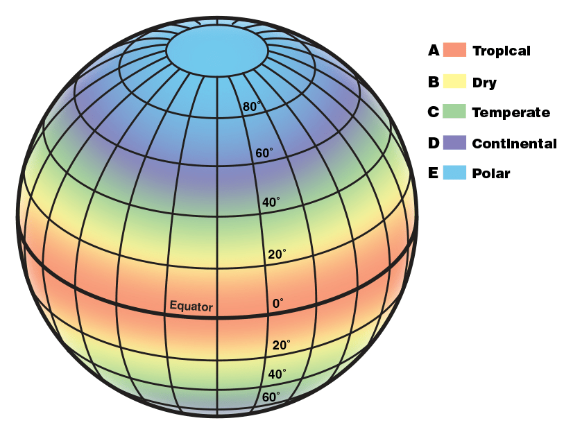
Q.11. State the various types of climate with suitable diagrams.
Ans:
Q.12. Write short notes on the following:
(a) Relative humidity.
(b) Atmosphere pressure.
(c) Pressure belts.
(d) Types of rainfall.
(e) Effect of latitudes on climate.
(f) Effect of vegetation on climate.
(g) Monsoon climate.
(h) Taiga type of climate.
(i) Meditation climate.
(J) Savanna climate.
(k) Tundra climate.
(I) Mountain climate
Ans: (a) Relative humidity: Air contains water vapour. It plays a significant role in the weather phenomena. The moisture present in the atmosphere is derived from water bodies through evaporation and plants through transpiration.
Therefore, there is a constant exchange of water between the atmosphere, the continents and the oceans through transpiration, evaporation, precipitation and condensation.
(b) Atmospheric pressure: also called barometric pressure, force per unit area exerted by an atmospheric column (that is, the entire body of air above the specified area). Atmospheric pressure can be measured with a mercury barometer (hence the commonly used synonym barometric pressure), which indicates the height of a column of mercury that exactly balances the weight of the column of atmosphere over the barometer.
(c) Pressure belts: A region on the earth that is dominated by either high pressure cells or low pressure cells is called a pressure belt. The horizontal distribution of air pressure across the latitudes is characterised by high or low-pressure belts. This is, however, a theoretical model because pressure belts are not always found as such on the earth.
These pressure belts are:
- The Equatorial Low Pressure Belt
- The Subtropic High Pressure Belts
- The Sub-polar Low Pressure Betts
- The Polar High Pressure Belts
(d) Types of rainfall: Rain is liquid water in the form of droplets that have condensed from atmospheric water vapour. Rain is an important factor in the water cycle. It handles most of the freshwater deposited on earth. Rain provides conditions for many ecosystems to co-exist in a habitat. It powers our hydroelectric plants. It is also used in crop irrigation.
There are three rainfall types:
- Convectional rainfall
- Orographic or relief rainfall
- Cyclonic or frontal rainfall
(e) Effect of latitude on climate: Here is a relationship between latitude and temperature around the world, as temperatures are typically warmer approaching the Equator and cooler approaching the Poles. There are variations, though, as other factors such as elevation, ocean currents, and precipitation affect climate patterns.
(f) Effect of vegetation on climate: One of the major controls of India’s climate is its latitude since the Tropic of Cancer passes through the middle of the country. That means, from the Rann of Kuchchh in the west to Mizoram in the east. However, almost half of the country, lying south of the Tropic of Cancer, belongs to the tropical area. All the remaining area, north of the Tropic, lies in the sub-tropics. Therefore, India’s climate has characteristics of tropical as well as subtropical climates.
(g) Monsoon climate: A monsoon is a seasonal change in the direction of the prevailing, or strongest, winds of a region. Monsoons cause wet and dry seasons throughout much of the tropics. Monsoons are most often associated with the Indian Ocean. Monsoons always blow from cold to warm regions. The average annual rainfall is between 100 and 200 cm. The region that receive annual rainfall between 100 and 200 cm have deciduous types of forest while region that get more than 200 cm of rainfall have evergreen forest.
(h) Taiga types of climate: The Taiga Type of Climate is characterized by a harsh, cold environment with little precipitation (snow and rain) and a short growing season. Winters can be long and severe, lasting up to six months, with average temperatures well below freezing. Summers are brief, with only 50 to 100 days without frost.
(i) Mediterranean climate: Mediterranean climate, major climate type of the Köppen classification characterized by hot, dry summers and cool, wet winters and located between about 30° and 45° latitude north and south of the Equator and on the western sides of the continents.
(j) Tundra climate: The tundra climate region geographically located between 60° and 75° of latitude, mostly along the Arctic coast of North America and Eurasia and on the coastal margins of Greenland. In such areas, winters are long and cold especially in the region north of the Arctic Circle.
Winter precipitation generally consists of dry snow. During summer cyclonic storms develop which yields rainfall.
Typical annual totals of rainfall are less than 35 cm, with a possible range of 25 to 100 cm. In contrast, summers are generally mild, with daily temperature maximum from 15 to 18 °C. Days are long but are often cloudy.
(k) Mountain climate: Mountain climates are distinguished by the departure of their characteristics from those of surrounding lowlands, and the one common basis for this distinction is that of atmospheric rarefaction. Aside from this, great variety is introduced by differences in latitude, elevation, and exposure to the sun. Thus, there exists no single, clearly defined, mountain climate. The most common climatic results of high elevation are those of decreased pressure, reduced oxygen availability, decreased temperature, and increased insolation; the last two combine to produce a typical “hot sun and cold shade” condition. Precipitation is heavier on the windward side of a mountain barrier than on the leeward (orographic precipitation), and on the windward side it increases upward to the zone of maximum precipitation, then decreases again.
Q.13. Answer the following question:
(a) How far does the atmosphere extend above from the earth surface?
Ans: 10,000 kilometers
(b) What is lapse rate?
Ans: The lapse rate is the rate at which the temperature of the atmosphere decreases with height. It is usually measured in degrees Celsius per kilometer. The average lapse rate in the atmosphere is about 6.5 degrees Celsius per kilometer. However, this can vary depending on factors such as humidity and atmospheric pressure.
(c) What is the average atmosphere pressure on the sea level?
Ans: Near-average, atmospheric pressure at sea level on the Earth is 1013.25 millibars, or about 14.7 pounds per square inch.
(d) What is humidity of air?
Ans: Humidity is the total amount of water vapor present in the air. Humidity depends on the amount of water vapor in the air. As the amount of water vapor in the air decreases, so does the humidity. If the humidity is high, the amount of water vapor in the air increases and this water vapor cools and causes precipitation.
(e) What is mean by term ‘saturated air’?
Ans: Saturated air holds as much water vapor as possible. Water vapor in saturated air has a partial pressure equal to the saturation pressure for the temperature of the air sample. When air is saturated, it is considered to have 100% relative humidity. Any attempt to add water vapor to the air will fail at that temperature – the excess water will condense.
(f) What is the latitudinal extension of the equatorial climate?
Ans: Equatorial type of climate, also known as tropical rainforest wet climate or simply Af climate, is located up to 5° to 10° latitudes on either side of the equator (fig. 39.1) but at some places it extends up to 15°-25° latitudes mainly along the eastern margins of the continents.
(g) In which climate is the compos grassland found?
Ans: Brazilian subtropical grasslands (known as Campos) are ecosystems under the constant influence of disturbance, mostly fire and grazing. Besides the humid climate in southern Brazil, with low variation in precipitation between months, grasslands are still present in these areas.
(h) Mentioned the latitudinal extension of the temperature desert climate region?
Ans: The major hot deserts of the world are located on the western coasts of continents between latitudes 30° and 40° N and S of the equator.
(i) What is the other name of Chinese climate?
Ans: Humid temperature climate.
(j) Give the example of irregular wind?
Ans: The earth has various types of winds, like the easterlies, westerlies, trade winds, monsoon winds, doldrums. It is the polar easterlies which are known to be the example of irregular winds moving from east and west.
(k) Why does the warm airmass have the capacity to hold more water vapour?
Ans: Warm air can hold more water vapor (humidity) than cold air, so with the same amount of absolute/specific humidity, the air will have more relative humidity. Having 50% relative humidity means that the air holds 50% of the water needed to saturate the air that day (at a given temperature).
(I) Why there is more atmosphere pressure at the lower level of the atmosphere?
Ans: At higher elevations, there are fewer air molecules above a given surface than a similar surface at lower levels. Since most of the atmosphere’s molecules are held close to the earth’s surface by the force of gravity, air pressure decreases rapidly at first, then more slowly at higher levels.

Hi, I’m Dev Kirtonia, Founder & CEO of Dev Library. A website that provides all SCERT, NCERT 3 to 12, and BA, B.com, B.Sc, and Computer Science with Post Graduate Notes & Suggestions, Novel, eBooks, Biography, Quotes, Study Materials, and more.

Please can u give me a some MCQs question from this chapter
Please can you give me a some mcq from this chapter